


<< Our Photo Pages >> Castro de Baroña - Castro or Chafurdão in Spain in Galicia
Submitted by ernar on Wednesday, 01 September 2004 Page Views: 6439
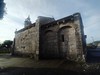
Iron Age and Later PrehistorySite Name: Castro de BaroñaCountry: Spain Region: Galicia Type: Castro or Chafurdão
Nearest Town: Santiago Compostela Nearest Village: Baroña
Latitude: 42.694614N Longitude: 9.031749W
Condition:
| 5 | Perfect |
| 4 | Almost Perfect |
| 3 | Reasonable but with some damage |
| 2 | Ruined but still recognisable as an ancient site |
| 1 | Pretty much destroyed, possibly visible as crop marks |
| 0 | No data. |
| -1 | Completely destroyed |
| 5 | Superb |
| 4 | Good |
| 3 | Ordinary |
| 2 | Not Good |
| 1 | Awful |
| 0 | No data. |
| 5 | Can be driven to, probably with disabled access |
| 4 | Short walk on a footpath |
| 3 | Requiring a bit more of a walk |
| 2 | A long walk |
| 1 | In the middle of nowhere, a nightmare to find |
| 0 | No data. |
| 5 | co-ordinates taken by GPS or official recorded co-ordinates |
| 4 | co-ordinates scaled from a detailed map |
| 3 | co-ordinates scaled from a bad map |
| 2 | co-ordinates of the nearest village |
| 1 | co-ordinates of the nearest town |
| 0 | no data |
Internal Links:
External Links:
I have visited· I would like to visit
kalcoatl would like to visit
HChavez visited - their rating: Cond: 3 Amb: 4 Access: 4
")
The "Cultura Castreña" ("Castreña Culture") brought by the Celt tribes meant the arrival of the Iron age to the NW area of the Iberian peninsula and is widely accepted to have started as soon as S. VII BC and lasted until after Roman conquest in S.II-IV AD. Castros (s. Castro) are a kind of settlement relatively common in northwestern Spain, composed of a fortified area (quite similar to the Irish or Scottish Stone Forts, but sligthly bigger in area) with a multitude of stone round huts inside it. In some later castros the Roman influence may be seen in rectangular/square buildings within the settlement.
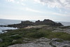
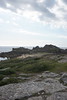
The Castro is built in an striking rocky peninsula linked to the mainland by a small sandy isthmus. The settlement primary defensive structure is composed of two 60 mt long strong ramparts while the secondary defense line is made of a triple staircased rampart which allows access to the dwelling area through a single entrance.
The settlement is divided in two by yet another rampart set orthogonally to the defensive grid.
If you are in Galicia, do not miss it. This one and the "Castro de Viladonga" in Lugo are two of the finest examples you will find.
PS: Latitude and Longitude are approximate data obtained through multimap. Do not expect you GPS to guide you to the middle of the Castro with it. You will find it signposted in the C-550 road.
Note: Our first Castro! Can you help us create the first worldwide megalithic database. Click here for more details.
You may be viewing yesterday's version of this page. To see the most up to date information please register for a free account.
")
")
Do not use the above information on other web sites or publications without permission of the contributor.
Nearby Images from Flickr

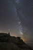
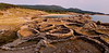
The above images may not be of the site on this page, but were taken nearby. They are loaded from Flickr so please click on them for image credits.
Click here to see more info for this site
Nearby sites
Click here to view sites on an interactive map of the areaKey: Red: member's photo, Blue: 3rd party photo, Yellow: other image, Green: no photo - please go there and take one, Grey: site destroyed
Download sites to:
KML (Google Earth)
GPX (GPS waypoints)
CSV (Garmin/Navman)
CSV (Excel)
To unlock full downloads you need to sign up as a Contributory Member. Otherwise downloads are limited to 50 sites.
Turn off the page maps and other distractions
Nearby sites listing. In the following links * = Image available
1.7km ENE 63° Monte da Gurita Petroglifo* Rock Art
2.9km SSW 194° Castro de Porto Nadelas Castro or Chafurdão
3.3km SSE 159° Castro da Lagoa (Porto do Son) Castro or Chafurdão
3.8km SSW 194° Castro da Illa do Mar Castro or Chafurdão
3.9km ENE 74° Castro de Enxa Castro or Chafurdão
7.3km E 98° Arca do Barbanza 2 Round Barrow(s)
7.3km E 98° Arca do Barbanza 1* Burial Chamber or Dolmen
7.3km E 94° Petroglifo do Rio Barbanza Rock Art
7.4km E 90° Túmulo Porto Traveso 1 Round Barrow(s)
7.5km E 90° Túmulo Porto Traveso 2 Round Barrow(s)
7.6km E 90° Túmulo Porto Traveso 3 Round Barrow(s)
7.7km E 95° Túmulo de Outeiriño Redondo* Round Barrow(s)
7.7km NW 325° Petroglifos das Pedras Louras Rock Art
7.7km ESE 115° Casarota do Fusiño Dolmen* Burial Chamber or Dolmen
7.8km E 89° Túmulo de Cavada 3 Round Barrow(s)
7.8km NNW 341° Petroglifos de O Cruceiro Rock Art
7.9km E 88° Dolmen de Cavada 2* Burial Chamber or Dolmen
7.9km E 88° Túmulo de Cavada 4 Round Barrow(s)
8.0km E 89° Dolmen de Cavada 1* Burial Chamber or Dolmen
8.0km E 86° Túmulo de Pedra da Xesta 1 Round Barrow(s)
8.0km E 86° Túmulo de Pedra da Xesta 3 Round Barrow(s)
8.0km E 86° Túmulo de Pedra da Xesta 2 Round Barrow(s)
8.0km E 85° Túmulo de Pedra da Xesta 5 Round Barrow(s)
8.1km E 83° Túmulo de Armadoiro 1* Round Barrow(s)
8.1km E 84° Túmulo de Poza da Lagoa Round Barrow(s)
View more nearby sites and additional images


 We would like to know more about this location. Please feel free to add a brief description and any relevant information in your own language.
 Wir möchten mehr über diese Stätte erfahren. Bitte zögern Sie nicht, eine kurze Beschreibung und relevante Informationen in Deutsch hinzuzufügen.
 Nous aimerions en savoir encore un peu sur les lieux. S'il vous plaît n'hesitez pas à ajouter une courte description et tous les renseignements pertinents dans votre propre langue.
 Quisieramos informarnos un poco más de las lugares. No dude en añadir una breve descripción y otros datos relevantes en su propio idioma.