

<< Text Pages >> Arca do Rabós - Burial Chamber or Dolmen in Spain in Galicia
Submitted by holger_rix on Monday, 14 December 2015 Page Views: 798
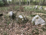
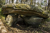
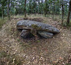
Neolithic and Bronze AgeSite Name: Arca do RabósCountry: Spain Region: Galicia Type: Burial Chamber or Dolmen
Latitude: 43.037568N Longitude: 9.02029W
Condition:
| 5 | Perfect |
| 4 | Almost Perfect |
| 3 | Reasonable but with some damage |
| 2 | Ruined but still recognisable as an ancient site |
| 1 | Pretty much destroyed, possibly visible as crop marks |
| 0 | No data. |
| -1 | Completely destroyed |
| 5 | Superb |
| 4 | Good |
| 3 | Ordinary |
| 2 | Not Good |
| 1 | Awful |
| 0 | No data. |
| 5 | Can be driven to, probably with disabled access |
| 4 | Short walk on a footpath |
| 3 | Requiring a bit more of a walk |
| 2 | A long walk |
| 1 | In the middle of nowhere, a nightmare to find |
| 0 | No data. |
| 5 | co-ordinates taken by GPS or official recorded co-ordinates |
| 4 | co-ordinates scaled from a detailed map |
| 3 | co-ordinates scaled from a bad map |
| 2 | co-ordinates of the nearest village |
| 1 | co-ordinates of the nearest town |
| 0 | no data |
Be the first person to rate this site - see the 'Contribute!' box in the right hand menu.
Internal Links:
External Links:
Burial Chamber (Dolmen) in Galicia
You may be viewing yesterday's version of this page. To see the most up to date information please register for a free account.
Do not use the above information on other web sites or publications without permission of the contributor.
Nearby Images from Flickr

The above images may not be of the site on this page, but were taken nearby. They are loaded from Flickr so please click on them for image credits.
Click here to see more info for this site
Nearby sites
Click here to view sites on an interactive map of the areaKey: Red: member's photo, Blue: 3rd party photo, Yellow: other image, Green: no photo - please go there and take one, Grey: site destroyed
Download sites to:
KML (Google Earth)
GPX (GPS waypoints)
CSV (Garmin/Navman)
CSV (Excel)
To unlock full downloads you need to sign up as a Contributory Member. Otherwise downloads are limited to 50 sites.
Turn off the page maps and other distractions
Nearby sites listing. In the following links * = Image available
88m WNW 285° Mámoa da Necrópole do Rabós 1 Round Barrow(s)
2.2km SSE 167° Castro de A Croa (A Bouza) Castro or Chafurdão
2.2km NW 307° Castro do Altiño de Padreiro Castro or Chafurdão
3.1km S 171° Pedra da Arca (Rogo Elle)* Burial Chamber or Dolmen
3.1km SSE 158° Anta do Alteiro Burial Chamber or Dolmen
3.3km SSE 149° Anta na Gándara de Baíñas Burial Chamber or Dolmen
3.3km ENE 75° Arca da Piosa* Burial Chamber or Dolmen
3.5km NNE 16° Bico dos Xentís Castro or Chafurdão
3.6km S 188° Castro de Regoelle Castro or Chafurdão
4.1km NW 310° Castro do Sino Castro or Chafurdão
4.4km NE 40° Pedra de Lebre* Burial Chamber or Dolmen
5.2km E 96° Arca da Piosa Dolmen (As Laxas) Burial Chamber or Dolmen
5.3km NW 316° Dolmen de Vilaseco Burial Chamber or Dolmen
5.5km NNW 331° Arca de Ogas Burial Chamber or Dolmen
5.5km WNW 282° Casota Dos Mouros Dolmen* Burial Chamber or Dolmen
5.9km NE 35° Pedra Moura de Carneo* Burial Chamber or Dolmen
6.0km WNW 286° Petróglifos do Pedrouso Rock Art
6.0km NW 312° Mámoa da Arquiña de Vilaseco Round Barrow(s)
6.1km ESE 123° Mámoa Os Currais Round Barrow(s)
6.5km NNE 27° Pedra Coberta Dolmen* Burial Chamber or Dolmen
6.7km W 265° Castro de Berdeogas Castro or Chafurdão
7.0km NNW 345° Castro das Barreiras Castro or Chafurdão
7.2km WNW 298° Petróglifo de Boallo* Rock Art
7.4km N 356° Castro de Trasouteiro Castro or Chafurdão
8.0km NNE 12° Castro de O Castro (Vimianzo) Castro or Chafurdão
View more nearby sites and additional images


 We would like to know more about this location. Please feel free to add a brief description and any relevant information in your own language.
 Wir möchten mehr über diese Stätte erfahren. Bitte zögern Sie nicht, eine kurze Beschreibung und relevante Informationen in Deutsch hinzuzufügen.
 Nous aimerions en savoir encore un peu sur les lieux. S'il vous plaît n'hesitez pas à ajouter une courte description et tous les renseignements pertinents dans votre propre langue.
 Quisieramos informarnos un poco más de las lugares. No dude en añadir una breve descripción y otros datos relevantes en su propio idioma.