


<< Our Photo Pages >> Tabasqueno - Ancient Village or Settlement in Mexico in Campeche
Submitted by davidmorgan on Thursday, 12 April 2007 Page Views: 4538
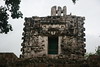
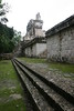
Multi-periodSite Name: Tabasqueno Alternative Name: TabasqueñoCountry: Mexico
NOTE: This site is 11.748 km away from the location you searched for.
Region: Campeche Type: Ancient Village or Settlement
Nearest Town: Dzibalchen
Latitude: 19.500220N Longitude: 89.78356W
Condition:
| 5 | Perfect |
| 4 | Almost Perfect |
| 3 | Reasonable but with some damage |
| 2 | Ruined but still recognisable as an ancient site |
| 1 | Pretty much destroyed, possibly visible as crop marks |
| 0 | No data. |
| -1 | Completely destroyed |
| 5 | Superb |
| 4 | Good |
| 3 | Ordinary |
| 2 | Not Good |
| 1 | Awful |
| 0 | No data. |
| 5 | Can be driven to, probably with disabled access |
| 4 | Short walk on a footpath |
| 3 | Requiring a bit more of a walk |
| 2 | A long walk |
| 1 | In the middle of nowhere, a nightmare to find |
| 0 | No data. |
| 5 | co-ordinates taken by GPS or official recorded co-ordinates |
| 4 | co-ordinates scaled from a detailed map |
| 3 | co-ordinates scaled from a bad map |
| 2 | co-ordinates of the nearest village |
| 1 | co-ordinates of the nearest town |
| 0 | no data |
Internal Links:
External Links:
I have visited· I would like to visit
davidmorgan has visited here
")
You may be viewing yesterday's version of this page. To see the most up to date information please register for a free account.
")
")
")
Do not use the above information on other web sites or publications without permission of the contributor.
Nearby Images from Flickr
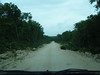
The above images may not be of the site on this page, but were taken nearby. They are loaded from Flickr so please click on them for image credits.
Click here to see more info for this site
Nearby sites
Click here to view sites on an interactive map of the areaKey: Red: member's photo, Blue: 3rd party photo, Yellow: other image, Green: no photo - please go there and take one, Grey: site destroyed
Download sites to:
KML (Google Earth)
GPX (GPS waypoints)
CSV (Garmin/Navman)
CSV (Excel)
To unlock full downloads you need to sign up as a Contributory Member. Otherwise downloads are limited to 50 sites.
Turn off the page maps and other distractions
Nearby sites listing. In the following links * = Image available
10.2km S 173° Hochob* Ancient Village or Settlement
21.6km ENE 66° Dzibilnocac* Ancient Village or Settlement
36.1km NNE 33° Santa Rosa Xtampak* Ancient Village or Settlement
48.1km WNW 283° Edzna* Ancient Village or Settlement
56.2km N 4° Miramar Ancient Village or Settlement
70.0km NNE 20° Kiuic* Ancient Village or Settlement
75.5km NNE 16° Paso del Macho* Ancient Village or Settlement
76.6km N 10° Sayil* Ancient Village or Settlement
77.2km NNE 14° Xlapak* Ancient Village or Settlement
77.7km NNE 16° Labna* Ancient Village or Settlement
84.4km N 10° Kabah* Ancient Village or Settlement
87.7km NNE 32° Chacmultun* Ancient Village or Settlement
87.9km WNW 296° Museo de la Arquitectura Maya* Museum
89.8km WNW 294° Museo Regional de Campeche* Museum
90.5km NNE 22° Grutas de Loltún* Cave or Rock Shelter
95.9km N 1° Uxmal* Ancient Village or Settlement
106.3km S 189° Balamkú* Ancient Village or Settlement
108.2km SSE 159° Chactún.* Ancient Village or Settlement
114.5km SSE 163° Becan* Ancient Village or Settlement
114.8km SSE 164° Chicanná* Ancient Village or Settlement
117.0km SSE 160° Xpuhil* Ancient Village or Settlement
119.3km N 351° Oxkintok* Ancient Village or Settlement
125.6km SSE 166° Hormiguero* Ancient Village or Settlement
130.0km NNE 15° Mayapan* Ancient Village or Settlement
141.8km SE 131° Kinichná* Ancient Village or Settlement
View more nearby sites and additional images


 We would like to know more about this location. Please feel free to add a brief description and any relevant information in your own language.
 Wir möchten mehr über diese Stätte erfahren. Bitte zögern Sie nicht, eine kurze Beschreibung und relevante Informationen in Deutsch hinzuzufügen.
 Nous aimerions en savoir encore un peu sur les lieux. S'il vous plaît n'hesitez pas à ajouter une courte description et tous les renseignements pertinents dans votre propre langue.
 Quisieramos informarnos un poco más de las lugares. No dude en añadir una breve descripción y otros datos relevantes en su propio idioma.