
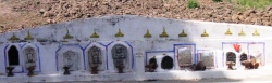

<< Our Photo Pages >> Nim Li Punit - Ancient Village or Settlement in Belize
Submitted by C_Michael_Hogan on Wednesday, 26 December 2007 Page Views: 13053
Multi-periodSite Name: Nim Li PunitCountry: Belize
NOTE: This site is 2.58 km away from the location you searched for.
Type: Ancient Village or Settlement
Nearest Town: Punta Gorda Nearest Village: Silver Creek
Latitude: 16.321470N Longitude: 88.82375W
Condition:
| 5 | Perfect |
| 4 | Almost Perfect |
| 3 | Reasonable but with some damage |
| 2 | Ruined but still recognisable as an ancient site |
| 1 | Pretty much destroyed, possibly visible as crop marks |
| 0 | No data. |
| -1 | Completely destroyed |
| 5 | Superb |
| 4 | Good |
| 3 | Ordinary |
| 2 | Not Good |
| 1 | Awful |
| 0 | No data. |
| 5 | Can be driven to, probably with disabled access |
| 4 | Short walk on a footpath |
| 3 | Requiring a bit more of a walk |
| 2 | A long walk |
| 1 | In the middle of nowhere, a nightmare to find |
| 0 | No data. |
| 5 | co-ordinates taken by GPS or official recorded co-ordinates |
| 4 | co-ordinates scaled from a detailed map |
| 3 | co-ordinates scaled from a bad map |
| 2 | co-ordinates of the nearest village |
| 1 | co-ordinates of the nearest town |
| 0 | no data |
Internal Links:
External Links:
I have visited· I would like to visit
C_Michael_Hogan has visited here
")
The analysis herein is based upon my site study of December, 2006 and a literature compilation.
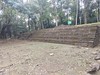
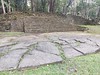
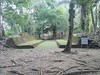
MONUMENTS. The architectural layout of Nim Li Punit features buildings developed proximate to three plazas, with a number of stepped-pyramids, the highest rising 12.2 meters. The design depends on considerable amounts of earth and rubble fill material to construct the sizable terraces and plazas; (Garber, 2004) The king's residence is centered within the city, with tombs and shrines at the north. A well preserved ballcourt is situated between the ruler's home and the burial area. The E Group was an astronomy center situated inside the Plaza of the Stelae; a number of the South Group monuments aligned with solstices and equinoxes stand in front of Structure One.
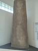
Numerous intricately carved stelae are found on the site. Measuring 9.5 meters, (Grube, 1999) Stela 15 is the tallest in Belize and second highest in the entire Mayan world; this stone is 81 centimeters in width. One of the stelae depicts a warrior king with an immense headdress, which led to the site naming of "Nim Li Punit" meaning ‘'big hat".
SETTLEMENT AND CULTURE. Of the five major sites in the southern Belize lowlands, Pusilha and Uxbenka to the west were settled early by Peten peoples; the founding of these two Mayan cities occurred about 450 AD, although it is not clear whether the settlement was by invasion or by acquisition of the Peten Maya culture by indigenous tribes. (Danien, 1992) Nim Li Punit and Xnaheb were occupied later (cycle nine of the Mayan calendar), while Lubaantun was settled at around the same time, although the latter has a debatable earlier founding. (Hogan, 2007). Danien suggests that Xnaheb was likely an offshoot of a ruling family of Nim Li Punit, based on similarities of iconography, culture and ceramics as well as stelae dating. Xnaheb lies 4.5 kilometers west of Nim Li Punit; although impressive in appearance, Xnaheb is the least substantive site, since its major works are facades built against hills.
These five major cities were also supported by some smaller, later settled Mayan towns within the total region of about 4000 square kilometers. The Silver Creek Mayan site is smaller and less developed; moreover, it is probably a later site not fully expanded when regional collapse occured. The Silver Creek, consisting of two architectural complexes with virtually no outlying residental settlement, was likely a satellite of Nim Li Punit.
Nim Li Punit achieved a zenith population approximating 5000 to 7000 people in the Late Classic period. (Department, 1999) The Mayan inhabitants here likely spoke a dialect of the Cholan language, the same found in the Mayan heartland. Based upon extant stelae dates, the civilization flourished here until 790, and the society collapsed in the ninth century. Interactions with Copan appear friendly, as the attendance of a ruler of Nim Li Punit at Copan was commemorated in the year 771. (Rice, 2004) Also the turbans characteristic of Nim Li Punit were similar to those of Copan.and Quirigua. (Looper, 2003) The carved bloodletting scenes at Nim Li Punit are generally conducted by females and are associated with passage events such as throne accession, birth and death; these iconographs are strikingly alike to those at Bonampak, Naranjo and Piedras Negras. (Gossen, 1999)
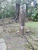
ENVIRONMENT. This site, situated in modern day Toledo District, was clearly selected by its ancient inhabitants for timber-laden forests, low turbidity stream access and agriculturally receptive soils. Nim Li Punit is a naturally defended site with the Maya Mountains forming an impenetrable thicket- like jungle on two sides (hosting the feared venomous "Bothrops asper" snake), while difficultly traversed coastal marsh lies at the east and south, the latter area positioned between the Temash and Sarstoon Rivers. The expansive view over the coastal plain provides an excellent lookout for guarding the complex. In the local streambed I found more sandstone, one of the main building materials for the site.
Our local Mayan guide pointed out numerous herbs that the ancients would have used for culinary and medicinal purposes, all of which continue to be used by local tribes today. I saw howler monkeys and paca at the site and considerable biodiversity in the encroaching secondary forest; however, greater species complexity existed in the original primary forest, which still exists at higher elevations. It is easy to imagine that milpa farming of the nutrient poor tropical soils could exhaust the agricultural capability over a few hundred years, leading to a sudden collapse of the Nim Li Punit people in the ninth century. Some theorists propound that many of the Mayan collapses included elements of social discontent and revolt from the rigid Mayan order, as food supplies dwindled. These ancient events are eerily similar to our own times where mass starvation is debated as to whether the cause is overreach of carrying capacity or poor governance. Isn't it obvious that both factors are at work when populations push against carrying capacity limits?
REFERENCES
* 'The ancient Maya of the Belize Valley: half a century of archaeological research'', ed. J.F.Garber, Gainesville University Press, Florida
* Nikolai Grube, Barbara MacLeod and Phil Wanyera (1999) ‘'The discovery, oxploration and Monuments of Nim Li Punit'‘, Washington Center for Maya Research, 39 pp.
* Elin C. Danien and Robert J. Sharer (1992) ‘'New Theories on the Ancient Maya'‘, University of Pennsylvania Museum of Archaeology ISBN 0924171138
* C. Michael Hogan (2007) ‘'Lubaantun'‘, the Megalithic Portal, ed. Andy Burnham
* Department of Archaeology, Belmopan, Belize (1999) '‘Nim Li Punit'‘, Project ACP-RPR 544, Cubola Productions, March, 1999
* Prudence M. Rice (2004) ‘'Maya Political Science: Time, Astronomy, and the Cosmos'‘, University of Texas Press, 376 pages ISBN 029270569
* Matthew George Looper (2003) ‘'Lightning Warrior: Maya Art and Kingship at Quirigua'‘, University of Texas Press, 265 pages ISBN 0292705565
* Gary H. Gossen (1999) ‘'Telling Maya Tales: Tzotzil Identities in Modern Mexico'‘, Routledge,
256 pages ISBN 0415914663
The above is original work of C. Michael Hogan prepared for the Megalithic Portal.
You may be viewing yesterday's version of this page. To see the most up to date information please register for a free account.
")
Do not use the above information on other web sites or publications without permission of the contributor.
Nearby Images from Flickr
The above images may not be of the site on this page, but were taken nearby. They are loaded from Flickr so please click on them for image credits.
Click here to see more info for this site
Nearby sites
Click here to view sites on an interactive map of the areaKey: Red: member's photo, Blue: 3rd party photo, Yellow: other image, Green: no photo - please go there and take one, Grey: site destroyed
Download sites to:
KML (Google Earth)
GPX (GPS waypoints)
CSV (Garmin/Navman)
CSV (Excel)
To unlock full downloads you need to sign up as a Contributory Member. Otherwise downloads are limited to 50 sites.
Turn off the page maps and other distractions
Nearby sites listing. In the following links * = Image available
15.1km WSW 253° Lubaantun* Ancient Village or Settlement
24.3km N 2° Quebrada de Oro Ancient Village or Settlement
24.6km ESE 104° Ka'k' Naab' saltworks Ancient Mine, Quarry or other Industry
58.3km NNW 328° Caracol Ancient Village or Settlement
91.7km NNW 343° Chaa Creek* Ancient Village or Settlement
91.9km NNW 338° Xunantunich* Ancient Village or Settlement
95.5km NNW 344° Cahal Pech Ancient Village or Settlement
95.7km NW 305° Chilonche Ancient Village or Settlement
96.8km NW 319° Holtun* Ancient Village or Settlement
101.7km NNW 333° Naranjo* Ancient Village or Settlement
103.5km NW 324° Yaxha* Ancient Village or Settlement
109.3km NNW 342° El Pilar* Ancient Village or Settlement
110.8km N 3° Saturday Creek Ancient Village or Settlement
113.4km NNW 327° Nakum* Ancient Village or Settlement
117.0km NW 308° Ixlú Ancient Village or Settlement
119.0km S 191° Quirigua* Ancient Village or Settlement
120.1km NNW 337° Holmul Ancient Village or Settlement
121.9km N 358° Cara Blanca Natural Stone / Erratic / Other Natural Feature
124.1km NNW 339° Cival Ancient Village or Settlement
132.0km NW 320° Tikal* Ancient Village or Settlement
132.4km WNW 301° Nojpetén* Ancient Village or Settlement
133.7km W 279° Ceibal* Ancient Village or Settlement
134.4km WSW 255° Cancuen* Ancient Village or Settlement
134.8km S 179° El Puente Ancient Village or Settlement
137.2km WNW 301° Nixtun-Ch'ich' Ancient Village or Settlement
View more nearby sites and additional images


 We would like to know more about this location. Please feel free to add a brief description and any relevant information in your own language.
 Wir möchten mehr über diese Stätte erfahren. Bitte zögern Sie nicht, eine kurze Beschreibung und relevante Informationen in Deutsch hinzuzufügen.
 Nous aimerions en savoir encore un peu sur les lieux. S'il vous plaît n'hesitez pas à ajouter une courte description et tous les renseignements pertinents dans votre propre langue.
 Quisieramos informarnos un poco más de las lugares. No dude en añadir una breve descripción y otros datos relevantes en su propio idioma.