


<< Our Photo Pages >> Balankanche Cave - Cave or Rock Shelter in Mexico in Yucatan
Submitted by davidmorgan on Friday, 20 February 2009 Page Views: 10953
Natural PlacesSite Name: Balankanche CaveCountry: Mexico
NOTE: This site is 9.154 km away from the location you searched for.
Region: Yucatan Type: Cave or Rock Shelter
Nearest Town: Piste
Latitude: 20.657937N Longitude: 88.534407W
Condition:
| 5 | Perfect |
| 4 | Almost Perfect |
| 3 | Reasonable but with some damage |
| 2 | Ruined but still recognisable as an ancient site |
| 1 | Pretty much destroyed, possibly visible as crop marks |
| 0 | No data. |
| -1 | Completely destroyed |
| 5 | Superb |
| 4 | Good |
| 3 | Ordinary |
| 2 | Not Good |
| 1 | Awful |
| 0 | No data. |
| 5 | Can be driven to, probably with disabled access |
| 4 | Short walk on a footpath |
| 3 | Requiring a bit more of a walk |
| 2 | A long walk |
| 1 | In the middle of nowhere, a nightmare to find |
| 0 | No data. |
| 5 | co-ordinates taken by GPS or official recorded co-ordinates |
| 4 | co-ordinates scaled from a detailed map |
| 3 | co-ordinates scaled from a bad map |
| 2 | co-ordinates of the nearest village |
| 1 | co-ordinates of the nearest town |
| 0 | no data |
Internal Links:
External Links:
I have visited· I would like to visit
Rileyy visited on 1st Jan 2006 - their rating: Cond: 4 Amb: 4 Access: 4 Steamy inside. Modern or recreated Maya offerings at end of cave. Underground stream in cave. Good small botanic garden outside the cave.
davidmorgan have visited here
")
A stalagmite and a stalactite have merged to form what appears to be a representation of the world tree, around which many offerings to the Toltec rain god, Tlaloc, have been placed.
You may be viewing yesterday's version of this page. To see the most up to date information please register for a free account.
")
")
")
Do not use the above information on other web sites or publications without permission of the contributor.
Nearby Images from Flickr
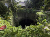
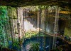


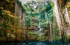
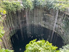
The above images may not be of the site on this page, but were taken nearby. They are loaded from Flickr so please click on them for image credits.
Click here to see more info for this site
Nearby sites
Click here to view sites on an interactive map of the areaKey: Red: member's photo, Blue: 3rd party photo, Yellow: other image, Green: no photo - please go there and take one, Grey: site destroyed
Download sites to:
KML (Google Earth)
GPX (GPS waypoints)
CSV (Garmin/Navman)
CSV (Excel)
To unlock full downloads you need to sign up as a Contributory Member. Otherwise downloads are limited to 50 sites.
Turn off the page maps and other distractions
Nearby sites listing. In the following links * = Image available
4.6km NW 307° Chichen Itza* Ancient Village or Settlement
18.6km SW 226° Yaxuna* Ancient Village or Settlement
28.3km W 276° Xtojil Cenote* Ancient Village or Settlement
48.8km ENE 58° Ek Balam* Ancient Village or Settlement
59.0km WNW 302° Izamal* Ancient Village or Settlement
85.9km WNW 292° Aké (Yucatan)* Ancient Village or Settlement
86.7km ESE 102° Coba'* Ancient Village or Settlement
87.8km NE 54° Kulubá* Ancient Village or Settlement
96.4km W 268° Mayapan* Ancient Village or Settlement
97.0km W 280° Acanceh* Ancient Village or Settlement
100.2km WSW 238° Chacmultun* Ancient Village or Settlement
102.8km ENE 60° San Manuel Cenote Cave or Rock Shelter
104.6km WNW 286° Xiol (Mérida) Ancient Village or Settlement
106.0km WSW 245° Grutas de Loltún* Cave or Rock Shelter
112.0km NW 311° Xcambo* Ancient Village or Settlement
115.7km ESE 124° Muyil* Ancient Village or Settlement
118.3km WNW 288° Mérida Anthropological Museum* Museum
119.1km WNW 287° Casa Frederick Catherwood* Museum
120.2km WNW 294° Dzibilchaltun* Ancient Village or Settlement
120.6km ESE 112° Hoyo Negro Cenote* Cave or Rock Shelter
121.5km WSW 244° Labna* Ancient Village or Settlement
122.8km WSW 243° Paso del Macho* Ancient Village or Settlement
123.3km WSW 239° Kiuic* Ancient Village or Settlement
124.0km WSW 244° Xlapak* Ancient Village or Settlement
124.6km WSW 249° Kabah* Ancient Village or Settlement
View more nearby sites and additional images


 We would like to know more about this location. Please feel free to add a brief description and any relevant information in your own language.
 Wir möchten mehr über diese Stätte erfahren. Bitte zögern Sie nicht, eine kurze Beschreibung und relevante Informationen in Deutsch hinzuzufügen.
 Nous aimerions en savoir encore un peu sur les lieux. S'il vous plaît n'hesitez pas à ajouter une courte description et tous les renseignements pertinents dans votre propre langue.
 Quisieramos informarnos un poco más de las lugares. No dude en añadir una breve descripción y otros datos relevantes en su propio idioma.