 with our Megalithic Portal iPhone app")


<< Other Photo Pages >> Old Cahawba Archaeological Park - Misc. Earthwork in United States in The South
Submitted by stonetracker on Tuesday, 14 February 2023 Page Views: 1102
Multi-periodSite Name: Old Cahawba Archaeological ParkCountry: United States
NOTE: This site is 53.83 km away from the location you searched for.
Region: The South Type: Misc. Earthwork
Nearest Town: Orrville AL
Latitude: 32.317403N Longitude: 87.096635W
Condition:
| 5 | Perfect |
| 4 | Almost Perfect |
| 3 | Reasonable but with some damage |
| 2 | Ruined but still recognisable as an ancient site |
| 1 | Pretty much destroyed, possibly visible as crop marks |
| 0 | No data. |
| -1 | Completely destroyed |
| 5 | Superb |
| 4 | Good |
| 3 | Ordinary |
| 2 | Not Good |
| 1 | Awful |
| 0 | No data. |
| 5 | Can be driven to, probably with disabled access |
| 4 | Short walk on a footpath |
| 3 | Requiring a bit more of a walk |
| 2 | A long walk |
| 1 | In the middle of nowhere, a nightmare to find |
| 0 | No data. |
| 5 | co-ordinates taken by GPS or official recorded co-ordinates |
| 4 | co-ordinates scaled from a detailed map |
| 3 | co-ordinates scaled from a bad map |
| 2 | co-ordinates of the nearest village |
| 1 | co-ordinates of the nearest town |
| 0 | no data |
Internal Links:
External Links:
I have visited· I would like to visit
stonetracker would like to visit
")
This village was the northern political center of a coastal Mississippian culture that controlled much of the region. Archaeologists have uncovered artifacts at this site that show how the inhabitants of this village were culturally connected to indigenous groups both at Moundville to the north and to those affiliated with the Pensacola phase along the Gulf Coast to the south.
Today, visitors can still see a portion of the moat, but the large mound inside the moat is no longer present. Historical records indicate that the mound was removed and used as fill in the construction of a nearby railroad embankment in the 1850s.
Location coordinates are for an interpretive sign at the intersection of Vine and Capitol Sts. The exact location of the remains of the moat is unclear.
For more info, see https://alabamamoundtrail.org/mound-site/old-cahawba/
You may be viewing yesterday's version of this page. To see the most up to date information please register for a free account.
")
")
Do not use the above information on other web sites or publications without permission of the contributor.
Nearby Images from Flickr

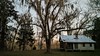
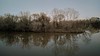

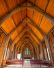
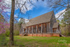
The above images may not be of the site on this page, but were taken nearby. They are loaded from Flickr so please click on them for image credits.
Click here to see more info for this site
Nearby sites
Click here to view sites on an interactive map of the areaKey: Red: member's photo, Blue: 3rd party photo, Yellow: other image, Green: no photo - please go there and take one, Grey: site destroyed
Download sites to:
KML (Google Earth)
GPX (GPS waypoints)
CSV (Garmin/Navman)
CSV (Excel)
To unlock full downloads you need to sign up as a Contributory Member. Otherwise downloads are limited to 50 sites.
Turn off the page maps and other distractions
Nearby sites listing. In the following links * = Image available
81.3km ENE 75° Mound at Fort Toulouse - Fort Jackson Park* Artificial Mound
92.0km NNW 327° Moundville Archeological Park* Ancient Village or Settlement
112.0km SSW 210° Mauvilla Ancient Village or Settlement
121.3km N 6° Bessemer Mounds* Artificial Mound
128.5km NE 41° Talladega Natl Forest Stone 1Ta719* Standing Stone (Menhir)
139.6km NE 42° Horn Mountain Stone Standing Stone (Menhir)
165.9km SSW 209° Bottle Creek* Ancient Village or Settlement
183.3km NE 42° Talladega National Forest Stone 1Ta756 Standing Stone (Menhir)
185.9km WNW 292° Nanih Waiya Mound* Artificial Mound
186.3km NE 53° Rother L. Harris Reservoir Stone Standing Stone (Menhir)
187.8km NE 40° Choccolocco Creek Mounds* Artificial Mound
188.0km WSW 250° Graveline Mound Site* Artificial Mound
188.2km NE 40° Oxford Stone Mound* Artificial Mound
191.2km SSW 204° Blakeley Indian Mounds* Artificial Mound
196.3km SSW 203° Fuller Shell Mound Site* Artificial Mound
197.1km NE 39° Choccolocco Stone Standing Stone (Menhir)
209.4km NE 37° Shelton Stone Mound Complex* Cairn
214.7km NNW 338° Hamilton Mounds* Artificial Mound
217.7km SSE 168° Fort Walton Mound* Artificial Mound
225.3km SSW 192° Bamahenge* Modern Stone Circle etc
225.5km ESE 114° Kolomoki Mounds Historic Park* Artificial Mound
225.9km NW 325° Nabers Mound Cemetery Site* Artificial Mound
234.6km SSW 193° Gulf State Park Shell and Sand Mounds* Artificial Mound
236.4km N 358° Oakville Mounds* Artificial Mound
243.8km NNW 328° Mound Cemetary* Artificial Mound
View more nearby sites and additional images


 We would like to know more about this location. Please feel free to add a brief description and any relevant information in your own language.
 Wir möchten mehr über diese Stätte erfahren. Bitte zögern Sie nicht, eine kurze Beschreibung und relevante Informationen in Deutsch hinzuzufügen.
 Nous aimerions en savoir encore un peu sur les lieux. S'il vous plaît n'hesitez pas à ajouter une courte description et tous les renseignements pertinents dans votre propre langue.
 Quisieramos informarnos un poco más de las lugares. No dude en añadir una breve descripción y otros datos relevantes en su propio idioma.