


<< Image Pages >> Ometepe Indigenous Cemetery - Ancient Village or Settlement in Nicaragua
Submitted by DrewParsons on Monday, 21 June 2010 Page Views: 4377
Multi-periodSite Name: Ometepe Indigenous CemeteryCountry: Nicaragua
NOTE: This site is 8.717 km away from the location you searched for.
Type: Ancient Village or Settlement
Nearest Town: Rivas
Latitude: 11.490000N Longitude: 85.55W
Condition:
| 5 | Perfect |
| 4 | Almost Perfect |
| 3 | Reasonable but with some damage |
| 2 | Ruined but still recognisable as an ancient site |
| 1 | Pretty much destroyed, possibly visible as crop marks |
| 0 | No data. |
| -1 | Completely destroyed |
| 5 | Superb |
| 4 | Good |
| 3 | Ordinary |
| 2 | Not Good |
| 1 | Awful |
| 0 | No data. |
| 5 | Can be driven to, probably with disabled access |
| 4 | Short walk on a footpath |
| 3 | Requiring a bit more of a walk |
| 2 | A long walk |
| 1 | In the middle of nowhere, a nightmare to find |
| 0 | No data. |
| 5 | co-ordinates taken by GPS or official recorded co-ordinates |
| 4 | co-ordinates scaled from a detailed map |
| 3 | co-ordinates scaled from a bad map |
| 2 | co-ordinates of the nearest village |
| 1 | co-ordinates of the nearest town |
| 0 | no data |
Be the first person to rate this site - see the 'Contribute!' box in the right hand menu.
Internal Links:
External Links:
")
Archaeologists have discovered the remains of an indigenous cemetery on the island of Ometepe in southern Nicaragua. Heavy rains in 2010 uncovered five human skeletons, bone fragments and pieces of pottery which date from 2500 BC to 2200 BC. Pre-Colombian artefacts as well as various petroglyphs have previously been found on Ometepe Island which was originally settled by the Choroteca and Nahuatel people who moved into the region from northern Mexico.
Between 1995 and 1999 The Ometepe Petroglyph Project served the Maderas half of Ometepe and mapped 73 archaeological sites within a 15 square kilometre area, including almost 1700 petroglyph panels on 1400 boulders - see separate page: "Ometepe" for details of the petroglyph project at: http://www.megalithic.co.uk/article.php?sid=23158
The spectacularly shaped twin volcano island is located in Lake Cocibolca and is a Unesco's World Network of Biosphere Reserve.
More at:
http://www.iol.co.za/index.php?set_id=1&click_id=31&art_id=nw20100608085648618C265352
http://en.wikipedia.org/wiki/Ometepe
You may be viewing yesterday's version of this page. To see the most up to date information please register for a free account.
Do not use the above information on other web sites or publications without permission of the contributor.
Nearby Images from Flickr

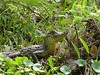
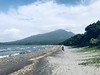
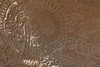
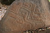
The above images may not be of the site on this page, but were taken nearby. They are loaded from Flickr so please click on them for image credits.
Click here to see more info for this site
Nearby sites
Click here to view sites on an interactive map of the areaKey: Red: member's photo, Blue: 3rd party photo, Yellow: other image, Green: no photo - please go there and take one, Grey: site destroyed
Download sites to:
KML (Google Earth)
GPX (GPS waypoints)
CSV (Garmin/Navman)
CSV (Excel)
To unlock full downloads you need to sign up as a Contributory Member. Otherwise downloads are limited to 50 sites.
Turn off the page maps and other distractions
Nearby sites listing. In the following links * = Image available
1.2km ESE 110° Ometepe* Rock Art
41.5km NW 311° Zapatero Island* Sculptured Stone
47.0km NW 313° Isla El Muerto* Rock Art
51.8km NW 320° Jinotepe* Rock Art
63.0km WNW 289° Riachuelo Cave* Rock Art
65.8km NW 318° San Francisco Museum (Granada) Museum
69.8km NNE 14° Aguas Buenas* Misc. Earthwork
71.6km NNE 16° Museo Arqueológico Gregorio Aguilar Barea* Museum
73.9km NW 305° Pensacola* Sculptured Stone
80.1km NW 311° Masaya Rock Art* Rock Art
104.9km NW 313° Footprints of Acahualinca Museum* Museum
104.9km NW 313° Managua Rock Art* Rock Art
138.8km NW 314° Momotombito Island* Sculptured Stone
165.4km NNW 340° Chaguitillo* Rock Art
179.4km NW 306° Subtiaba* Ancient Village or Settlement
182.3km SE 140° Williamsberg Mounds* Artificial Mound
188.0km SE 133° Anita Grande* Artificial Mound
226.4km SE 139° Santa Ana, San José Carving
235.8km SE 137° Parque de la Merced Carving
236.7km SE 137° San José Legislative Assembly Carving
236.8km SE 137° Museo Nacional de Costa Rica Museum
237.0km SE 137° Plaza de la Justicia Carving
237.1km SE 137° San José Supreme Court Carving
238.9km SE 142° Orosi* Artificial Mound
239.2km SE 126° Liceo Barrow Cemetery
View more nearby sites and additional images


 We would like to know more about this location. Please feel free to add a brief description and any relevant information in your own language.
 Wir möchten mehr über diese Stätte erfahren. Bitte zögern Sie nicht, eine kurze Beschreibung und relevante Informationen in Deutsch hinzuzufügen.
 Nous aimerions en savoir encore un peu sur les lieux. S'il vous plaît n'hesitez pas à ajouter une courte description et tous les renseignements pertinents dans votre propre langue.
 Quisieramos informarnos un poco más de las lugares. No dude en añadir una breve descripción y otros datos relevantes en su propio idioma.