


<< Other Photo Pages >> Candies Creek Village Archaeological Preserve - Ancient Village or Settlement in United States in The South
Submitted by bat400 on Wednesday, 14 May 2008 Page Views: 11604
Multi-periodSite Name: Candies Creek Village Archaeological PreserveCountry: United States Region: The South Type: Ancient Village or Settlement
Nearest Town: Cleveland, TN
Latitude: 35.219600N Longitude: 84.8923W
Condition:
| 5 | Perfect |
| 4 | Almost Perfect |
| 3 | Reasonable but with some damage |
| 2 | Ruined but still recognisable as an ancient site |
| 1 | Pretty much destroyed, possibly visible as crop marks |
| 0 | No data. |
| -1 | Completely destroyed |
| 5 | Superb |
| 4 | Good |
| 3 | Ordinary |
| 2 | Not Good |
| 1 | Awful |
| 0 | No data. |
| 5 | Can be driven to, probably with disabled access |
| 4 | Short walk on a footpath |
| 3 | Requiring a bit more of a walk |
| 2 | A long walk |
| 1 | In the middle of nowhere, a nightmare to find |
| 0 | No data. |
| 5 | co-ordinates taken by GPS or official recorded co-ordinates |
| 4 | co-ordinates scaled from a detailed map |
| 3 | co-ordinates scaled from a bad map |
| 2 | co-ordinates of the nearest village |
| 1 | co-ordinates of the nearest town |
| 0 | no data |
Internal Links:
External Links:
")
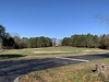
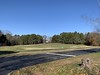
Modern Tennessee subdivision is home to ancient village. Upon entering Princeton Hills subdivision off Freewill Road, visitors see a wide expanse of green space bordered by a circular drive. Large, expensive homes surround the green, grassy mound in an arrangement akin to a prehistoric village. In a sense, that is exactly what the mound represents. It is the five-acre site of the Candies Creek Village Archaeological Preserve owned by the Archaeological Conservancy. It contains the remains of houses, human burials and pit features.
Developer Jim Sharp sold the site to the Conservancy in 2001 to ensure its protection. The land was valued at $300,000. Sharp sold it for $174,000. It is the only one of its kind preserved in eastern Tennessee.
According to Alan Gruber, Southeastern Regional director, The Archaeological Conservancy, "People throughout the South are surprised to learn that important archaeological sites are found not only in placs like Egypt and Centeral America, but are also right in their own backyards."
Beyond the homes is Candies Creek. The rich soil was ideal for farming by Woodland and Mississippian Native Americans and much later by the Cherokee. After the removal of the native people in 1838, the land was farmed by white settlers until it was sold for development.
It is difficult to know what vegetation there must have been prior to European colonization and westward expansion of the United States of America. The only clues can be found along Candies Creek and slopes of Candies Creek Ridge.
The site was known to have intact deposits, but how much and what kind was unknown until the site was excavated in 1991 by Lee (University) College.
The most plentiful material found was stone debris left from manufacturing tools used as scrapers, drills and projectile points ranging in age from the Woodland III Period, 350 to 900 A.D., and the Mississippian Period dates from 1300 to 1800 A.D.
The second most prevalent material was pottery shards.
Corn cultivation occurred in the Woodland III era though deer hunting and hickory nuts remained as the main food staples. In the Mississippian stage, there was an intensive use of maize, squash, pumpkins, gourds and sunflowers. Deer, squirrel, raccoon, pigeon and turkey were primary staples.
The mound marks a transition between limestone tempering of the Woodland III phase and shell tempering of the Mississippians. The Mississippian II Period was from 1,000 to 1,300 A.D. It is characterized by permanent stockaded villages of large civil structures erected on mounds at opposite ends of an open plaza.
Available dietary data shows corn as the primary food staple along with squash and beans. Hunting, fishing and gathering continued as important foods.
According to Gruber, the Mississippian period began about 900-1550.
"The period represents what is arguably the height of American Indian cultures in the United States. The culture began at the Mississippi River between St. Louis and Vicksburg (Miss.) and spread along river systems until it covered most of the Southeast."
There was no unified political or cultural body, but a regional distribution of villages and towns within feudal-like provinces sharing similar social, cultural and economic practices.
"The Mississippian represented a marked advance from past Southeastern cultures. Increased agricultural productivity during this time resulted in increased population, which led to greater social, political and religious complexity than had existed previously north of Mexico."
Their towns were large with 20 - 200 structures and populations between 50 and 50,000 people. They built massive religious monuments and as their population increased, newer and more sophisticated political and economic structures were formed. While the unpredictable method of hunting and gathering was still employed, intensive agriculture and use of hardy seed varieties provided a much more dependable food supply.
Because the Mississippians were dependent on cultivation of the land, they were less mobile than earlier civilizations. All of the people in a village worked to provide for their community's basic needs. Women did most of the farming, cook and childcare while the men hunted, built and repaired structures and went to war with disagreeable neighbors.
Because of agriculture, the Mississippians had plenty of time to develop cultural practices to enrich their lives such as playing games, crafts and religious rituals.
"The Mississippian culture died out after the mid-1500s, when Hernando de Soto's expeditions passed through North America, bringing European diseases to the New World. People in the Americas had no natural immunity to Old world pathogens like smallpox, influenza and measles. Massive pandemics killed off between 85 percent and close to 100 percent of the Mississippian population," according to Gruber. "There is still much to learn about the Mississippian culture. The Candies Creek site will help archaeologists, anthropologists and historians add to our knowledge of this fascinating period in our nation's prehistory."
More, with a photo in the the Cleveland Daily Banner.
You may be viewing yesterday's version of this page. To see the most up to date information please register for a free account.
Do not use the above information on other web sites or publications without permission of the contributor.
Nearby Images from Flickr


The above images may not be of the site on this page, but were taken nearby. They are loaded from Flickr so please click on them for image credits.
Click here to see more info for this site
Nearby sites
Click here to view sites on an interactive map of the areaKey: Red: member's photo, Blue: 3rd party photo, Yellow: other image, Green: no photo - please go there and take one, Grey: site destroyed
Download sites to:
KML (Google Earth)
GPX (GPS waypoints)
CSV (Garmin/Navman)
CSV (Excel)
To unlock full downloads you need to sign up as a Contributory Member. Otherwise downloads are limited to 50 sites.
Turn off the page maps and other distractions
Nearby sites listing. In the following links * = Image available
24.2km NNW 339° Hiwassee Island Mounds* Artificial Mound
36.6km WSW 247° Roxbury Indian Mound* Artificial Mound
53.9km SSE 161° Fort Mountain Stone Enclosure* Cairn
87.8km WSW 252° Russell Cave* Cave or Rock Shelter
87.8km WSW 252° Russell Cave Mound* Artificial Mound
99.4km E 83° Sculptured Stone near Robbinsville* Sculptured Stone
99.6km ESE 112° Track Rock* Rock Art
100.4km ESE 112° Track Rock Gap Archaeological Area* Stone Row / Alignment
104.6km SSE 163° Funk Heritage Center* Museum
108.2km NNW 342° Monterey Standing Stone* Standing Stone (Menhir)
114.0km WNW 285° Old Stone Fort* Hillfort
117.0km ESE 119° Hickorynut Track Rock* Rock Art
118.1km NE 47° University of Tennessee Agriculture Farm Mound* Barrow Cemetery
119.4km NE 47° McClung Museum of Natural History and Culture* Museum
119.7km S 177° Arborrigg* Modern Stone Circle etc
121.6km S 176° Etowah Mounds Museum* Museum
121.7km S 176° Etowah Mounds - Ditch and Palisade* Misc. Earthwork
122.0km S 176° Etowah Mounds - Mound A* Artificial Mound
122.0km S 176° Etowah Mounds - Mound C* Artificial Mound
122.1km S 176° Etowah Mounds - Mound B* Artificial Mound
123.2km ESE 119° Nacoochee* Barrow Cemetery
125.5km SSW 211° Coker Ford Site* Ancient Village or Settlement
125.5km ESE 118° Kenimer* Artificial Mound
125.7km ESE 118° Sautee-Nacoochee earthwork Ancient Village or Settlement
133.9km E 87° Cowee Mound Artificial Mound
View more nearby sites and additional images


 We would like to know more about this location. Please feel free to add a brief description and any relevant information in your own language.
 Wir möchten mehr über diese Stätte erfahren. Bitte zögern Sie nicht, eine kurze Beschreibung und relevante Informationen in Deutsch hinzuzufügen.
 Nous aimerions en savoir encore un peu sur les lieux. S'il vous plaît n'hesitez pas à ajouter une courte description et tous les renseignements pertinents dans votre propre langue.
 Quisieramos informarnos un poco más de las lugares. No dude en añadir una breve descripción y otros datos relevantes en su propio idioma.