Featured: Explore Scotland (and everywhere else) with our Megalithic Portal iPhone app

Explore Scotland (and everywhere else) with our Megalithic Portal iPhone app

Britain BC

Britain BC

Who's Online

There are currently, 251 guests and 2 members online.

You are a guest. To join in, please register for free by clicking here

Sponsors

<< Other Photo Pages >> Nikwasi Mound - Artificial Mound in United States in The South

Submitted by bat400 on Wednesday, 10 February 2010  Page Views: 10695

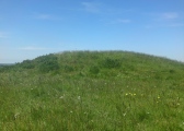
Pre-ColumbianSite Name: Nikwasi Mound Alternative Name: 31MA1
Country: United States
NOTE: This site is 21.541 km away from the location you searched for.

Region: The South Type: Artificial Mound
Nearest Town: Franklin, N Carolina
Latitude: 35.185020N  Longitude: 83.373629W
Condition:
5Perfect
4Almost Perfect
3Reasonable but with some damage
2Ruined but still recognisable as an ancient site
1Pretty much destroyed, possibly visible as crop marks
0No data.
-1Completely destroyed
4 Ambience:
5Superb
4Good
3Ordinary
2Not Good
1Awful
0No data.
3 Access:
5Can be driven to, probably with disabled access
4Short walk on a footpath
3Requiring a bit more of a walk
2A long walk
1In the middle of nowhere, a nightmare to find
0No data.
5 Accuracy:
5co-ordinates taken by GPS or official recorded co-ordinates
4co-ordinates scaled from a detailed map
3co-ordinates scaled from a bad map
2co-ordinates of the nearest village
1co-ordinates of the nearest town
0no data
4

Internal Links:
External Links:

Nikwasi Mound
Nikwasi Mound submitted by Flickr : Nikwasi Indian Mound, Franklin, North Carolina, More Information and Pictures... whowont.com/wisdom/north-america/nikwasi.html Image copyright: whowont.com, hosted on Flickr and displayed under the terms of their API. (Vote or comment on this photo)
Artificial Mound in Macon County, North Carolina. A structural earthwork mound. Europeans first entering this area in the 1700's found a Cherokee village with a council house built here.

Like nearby Cowee Mound, the size and shape of this mound, and prehistoric finds in the area, lead to a belief that the mound was originally built during the era of the Mississippian cultures.

Whether the Cherokee migrated to these areas after the collapse of the Mississippian cultures, or were part of that culture, the historic Cherokee used this mounds as a platform for important buildings in this village.

See the webpage at Cherokee Heritage Trails.

Note: Ground-penetrating radar detects over 100 objects in Ancient Tribal Mound, see comment. “It’s full of stuff.”
You may be viewing yesterday's version of this page. To see the most up to date information please register for a free account.


Nikwasi Mound
Nikwasi Mound submitted by Flickr : Historical marker at Nikwasi. Image copyright: MTBradley (Matthew T. Bradley), hosted on Flickr and displayed under the terms of their API. (Vote or comment on this photo)

Nikwasi Mound
Nikwasi Mound submitted by Flickr : The western side of Nikwasi Mound (31Ma2). East Main St./NC 28 can be seen at the right side of the photo. It passes in front of the mound Image copyright: MTBradley (Matthew T. Bradley), hosted on Flickr and displayed under the terms of their API. (Vote or comment on this photo)

Nikwasi Mound
Nikwasi Mound submitted by Flickr : Nikwasi Indian Mound, Franklin, NC. From PhC.184 Massengill Postcard Collection, initial donation, State Archives of North Carolina, Raleigh, NC. Image copyright: State Archives of North Carolina (State Archives of North Carolina Raleigh, NC), hosted on Flickr and displayed under the terms of their API. (Vote or comment on this photo)

Do not use the above information on other web sites or publications without permission of the contributor.

Nearby Images from Flickr
IMG_0669
IMG_1230
IMG_0177
IMG_1265
Post Office 28734 (Franklin, North Carolina)
First Presbyterian Church (Franklin, North Carolina)

The above images may not be of the site on this page, but were taken nearby. They are loaded from Flickr so please click on them for image credits.


Click here to see more info for this site

Nearby sites

Click here to view sites on an interactive map of the area

Key: Red: member's photo, Blue: 3rd party photo, Yellow: other image, Green: no photo - please go there and take one, Grey: site destroyed

Download sites to:
KML (Google Earth)
GPX (GPS waypoints)
CSV (Garmin/Navman)
CSV (Excel)

To unlock full downloads you need to sign up as a Contributory Member. Otherwise downloads are limited to 50 sites.


Turn off the page maps and other distractions

Nearby sites listing. In the following links * = Image available
 9.8km NNW 335° Cowee Mound Artificial Mound
 26.9km ENE 61° Judaculla Rock* Rock Art
 28.3km N 355° Kituwah* Ancient Village or Settlement
 33.9km N 9° Museum of the Cherokee Indian* Museum
 42.2km WNW 292° Sculptured Stone near Robbinsville* Sculptured Stone
 56.5km SW 233° Track Rock Gap Archaeological Area* Stone Row / Alignment
 56.7km SW 234° Track Rock* Rock Art
 61.9km SSW 207° Sautee-Nacoochee earthwork Ancient Village or Settlement
 62.5km SSW 207° Kenimer* Artificial Mound
 63.6km SSW 209° Nacoochee* Barrow Cemetery
 63.8km SW 214° Hickorynut Track Rock* Rock Art
 66.0km ESE 116° South Carolina Rock Art Center* Rock Art
 84.2km ENE 62° Biltmore Mound Artificial Mound
 93.0km NNE 32° Hot Springs (North Carolina)* Holy Well or Sacred Spring
 98.9km NNW 330° McClung Museum of Natural History and Culture* Museum
 99.0km NNW 329° University of Tennessee Agriculture Farm Mound* Barrow Cemetery
 106.3km ENE 72° Chimney Rock (North Carolina)* Natural Stone / Erratic / Other Natural Feature
 114.7km SSE 157° Georgia Guidestones* Modern Stone Circle etc
 128.0km S 180° Sandy Creek terrace complex* Ancient Village or Settlement
 129.7km WSW 249° Fort Mountain Stone Enclosure* Cairn
 138.0km W 272° Candies Creek Village Archaeological Preserve* Ancient Village or Settlement
 144.4km SW 229° Funk Heritage Center* Museum
 148.9km W 281° Hiwassee Island Mounds* Artificial Mound
 163.3km N 359° Ely Mound* Artificial Mound
 171.4km NE 54° Split Rock / Sphinx Rock* Natural Stone / Erratic / Other Natural Feature
View more nearby sites and additional images

<< Naranjo

Dickson Mounds >>

Please add your thoughts on this site

The Pagan Religions of the Ancient British Isles - Hutton

The Pagan Religions of the Ancient British Isles - Hutton

Sponsors

Auto-Translation (Google)

Translate from English into:

"Nikwasi Mound" | Login/Create an Account | 5 News and Comments
  
Go back to top of page    Comments are owned by the poster. We aren't responsible for their content.
Street View Nikwasi Mound by bat400 on Thursday, 08 April 2010
(User Info | Send a Message)

View Larger Map
[ Reply to This ]

Re: Exploring the mystery of the Nikwasi Mound by bat400 on Tuesday, 23 February 2010
(User Info | Send a Message)
I'm afraid I disagree with you. Not knowing would be worse. The people involved are highly motivated to prove that their oral tradition is based on fact.
And besides, Nikwasi Mound is in the middle of large town, with little or no cover. A looter is highly unlikely to pull up his backhoe and start in.

If you are actually concerned that GPR will become the new tool of looters, they seem to be doing just fine with shovels, backhoes, and long metal probes.
[ Reply to This ]

Re: Exploring the mystery of the Nikwasi Mound by glen on Monday, 22 February 2010
(User Info | Send a Message)
is anyone else disturbed by the use of this technology to 'reveal' intriguing 'objects' 8 feet underground? in the wrong hands - and it will get there - this will be worse than the metal-detectorist bonanza of despoilation.
the reason this was done in this mound was that it is "non-invasive". now it's widely known to be "full of stuff" the 'finders' have a duty to either dig it, or protect it 24/7.
the technology can't be un-discovered, so now all un-dug un-manned sites are under real threat
[ Reply to This ]

Exploring the mystery of the Nikwasi Mound by Andy B on Friday, 12 June 2009
(User Info | Send a Message)

After years of speculation, the contents of the Nikwasi Mound may finally be revealed.

Scientists and members of the Cherokee Preservation Foundation met at the mound in downtown Franklin recently for the opportunity to use a ground-penetrating radar unit to glean information from the ancient tribal mound. Blair Tormey, professor of geology at Western Carolina University, said that a ground penetrating radar unit is one of the best ways to discover what may be there.

“It’s non-invasive,” said Cherokee Preservation Foundation member Bill Evans.

Tormey pushed the machine up and over the mound to create a cross-section image from various angles. The unit used penetrates eight feet of depth, reflecting images through radar technology. He then started creating a grid by 10-foot spacings.

“We hope to map the upper eight feet,” he said. The 10-foot grid will outline areas of interest to zoom in and map closer.

Tormey said that the earth looked “disturbed” versus “natural” under the mound, perhaps due to packing. Eight or nine boulder-sized objects were visible on the screen. The objects, he said, could be stones or post holes from a former structure and are located within the top two feet of the mound.

Anne Rogers and Bill Dyar of the Little Tennessee Land Trust look on as geologist Blair Tormey from WCU explains the visuals on the screen of the ground penetrating radar unit used Wednesday to look inside the Nikwasi Indian Mound, built circa 1100 A.D.
Evidence suggests however that the mound may extend further out than is still visible. “One thing is, we can see where the mound starts and ends,” said Tormey.

Tormey said he will likely spend two days at Nikwasi. In a few weeks, he should have a map for viewing.

Tormey said he will use scenes collected from the unit to create a three-dimensional image on his computer. The software can interpret between the 10-foot spacings.

“We will scope out the object for a best guess,” he said.

The crew will also use the unit at other mounds in Macon County. Tormey said the Nikwasi Mound will be used as a type of test mound for the procedure because it is so well defined, free of trees and of well known history.

Objects may even be easier to see at mounds than are more flat due to the level of penetration. Once objects are noted on the screen, they can be flagged to help discern the limits and proportions of possible structures or random objects.

The Nikwasi Mound is protected, so it is unlikely that any excavating would occur. Anne Rogers, with the Department of Anthropology and Archaeology at WCU, recalled attending a Nikwasi dedication ceremony years ago.

She said that after local politicians spoke at the ceremony, Cherokee speaker Robert Bushyhead walked past the microphone and climbed the mound to address those assembled. Bushyhead spoke in Cherokee. Rogers said suddenly the clouds parted and the sun illuminated him. “I had an appreciate for this as Cherokee land,” said Rogers.

It is speculated that the Nikwasi Mound was built around 1100 A.D. and that a tribal council house once sat at the top, where a depression is still visible. Rogers said it is thought that the building of mounds was a type of social control to organize the men and keep people busy when they were not farming.

The Cherokee Preservation Foundation aims to inventory and preserve culturally significant sites.

“We’ve got to study our history now,” said Foundation member Sam Greenwood. No such work has been previously catalogued in the area.

“It’s a neat project,” said Tormey. “I am excited to be a part of it.”

(with thanks to Coldrum for finding this)

http://www.maconnews.com/index.php?opti

Read the rest of this post...
[ Reply to This ]
    Over 100 objects detected within Nikwasi Mound by bat400 on Wednesday, 10 February 2010
    (User Info | Send a Message)
    Submitted by coldrum ----

    A geologist who studied the Nikwasi Mound with a ground penetrating radar unit over the summer revealed his findings at the Franklin Town Hall last week. “It’s full of stuff, whatever it is,” said Western Carolina University Professor of Geology Blair Tormey of the Nikwasi Mound, located in downtown Franklin. Tormey has been working through the local Native American Cultural Sites Preservation Project to study and document the Nikwasi Mound.

    Last June, Tormey used a ground penetrating radar unit to create mapping of the interior of the mound. He presented his findings to interested parties last Friday, Jan. 29. WCU Anthropology and Archaeology Professor Anne Rogers, Franklin Town Manager Sam Greenwood, Sharon Taylor with the Little Tennessee Land Trust and project supervisor Bill Evans were all in attendance.

    Tormey said that his findings have revealed 123 targets, or objects, within the mound.

    Tormey said that objects made of metal, such as utility lines and pipes, are easily picked out due to the signal received on the equipment. In addition to the 123 objects, or artifacts, detected within the mound’s boundaries, another 146 objects were detected outside the mound’s boundaries. “The objects found have weaker signals,” he said. “But, in terms of knowing what they are, it is a challenge.”

    One object was one square meter in size and extended vertically from the top of the mound to the bottom. “It looks like a column going from top to bottom,” said Evans. He suggested the detected column could have been a hollow cedar log smoke stack that the Cherokee used to keep a fire going at all times.

    “Everyone lit their fires from the central fire,” agreed Rogers. Tormey spoke of eternal flame mounds that used a cedar log to house the fire, packing dirt around the log as the mound continued to rise in height.

    Another interesting find was a perfect oval that measures 50 feet by 30 feet in dimension. “It could be a small mound,” Tormey said of what he called a “large sub-mound structure” within the mound itself. No objects were located within the oval although the earth was clearly very densely packed within the defined space.

    Since the Nikwasi Mound is protected, excavation is not likely. Rogers said that it would be interesting to see the similarities or differences between GPR findings at Nikwasi and at other area mounds such as the Cowee Mound. “There are still some that are accessible and could be studied,” she said.

    Referring to mounds that have been lost to development or other causes, Rogers said, “The more we find out about these particular towns, the more we will understand the ones we will never see again.”

    The Native American Cultural Sites Preservation Project seeks to inventory and preserve culturally significant sites.


    For more, see http://www.maconnews.com/index.php?option=com_content&task=view&id=6291&Itemid=34.
    [ Reply to This ]

Your Name: Anonymous [ Register Now ]
Subject:


Add your comment or contribution to this page. Spam or offensive posts are deleted immediately, don't even bother

<<< What is five plus one as a number? (Please type the answer to this question in the little box on the left)
You can also embed videos and other things. For Youtube please copy and paste the 'embed code'.
For Google Street View please include Street View in the text.
Create a web link like this: <a href="https://www.megalithic.co.uk">This is a link</a>  

Allowed HTML is:
<p> <b> <i> <a> <img> <em> <br> <strong> <blockquote> <tt> <li> <ol> <ul> <object> <param> <embed> <iframe>

We would like to know more about this location. Please feel free to add a brief description and any relevant information in your own language.
Wir möchten mehr über diese Stätte erfahren. Bitte zögern Sie nicht, eine kurze Beschreibung und relevante Informationen in Deutsch hinzuzufügen.
Nous aimerions en savoir encore un peu sur les lieux. S'il vous plaît n'hesitez pas à ajouter une courte description et tous les renseignements pertinents dans votre propre langue.
Quisieramos informarnos un poco más de las lugares. No dude en añadir una breve descripción y otros datos relevantes en su propio idioma.