


<< Other Photo Pages >> Portsmouth Earthworks - Misc. Earthwork in United States in Great Lakes Midwest
Submitted by AKFisher on Friday, 22 February 2013 Page Views: 7035
Pre-ColumbianSite Name: Portsmouth EarthworksCountry: United States
NOTE: This site is 2.077 km away from the location you searched for.
Region: Great Lakes Midwest Type: Misc. Earthwork
Nearest Town: Portsmouth
Latitude: 38.743083N Longitude: 82.97775W
Condition:
| 5 | Perfect |
| 4 | Almost Perfect |
| 3 | Reasonable but with some damage |
| 2 | Ruined but still recognisable as an ancient site |
| 1 | Pretty much destroyed, possibly visible as crop marks |
| 0 | No data. |
| -1 | Completely destroyed |
| 5 | Superb |
| 4 | Good |
| 3 | Ordinary |
| 2 | Not Good |
| 1 | Awful |
| 0 | No data. |
| 5 | Can be driven to, probably with disabled access |
| 4 | Short walk on a footpath |
| 3 | Requiring a bit more of a walk |
| 2 | A long walk |
| 1 | In the middle of nowhere, a nightmare to find |
| 0 | No data. |
| 5 | co-ordinates taken by GPS or official recorded co-ordinates |
| 4 | co-ordinates scaled from a detailed map |
| 3 | co-ordinates scaled from a bad map |
| 2 | co-ordinates of the nearest village |
| 1 | co-ordinates of the nearest town |
| 0 | no data |
Internal Links:
External Links:
I have visited· I would like to visit
rrmoser visited on 12th May 2015 - their rating: Cond: 3 Amb: 4 Access: 5 Only one horseshoe shaped mound remains in Portsmouth. Easy to visit and despite its modest size and location in a city park it still had a good ambience.
bat400 visited - their rating: Cond: 2 Amb: 3 Access: 5
Average ratings for this site from all visit loggers: Condition: 2.5 Ambience: 3.5 Access: 5
")
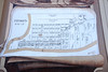
The major parts of the complex are known as Group A (west of modern Portsmouth, in Kentucky,) Group B (now covered by modern Portsmouth,) and Group C (east of Portsmouth, near South Shore, Kentucky.) and Group D, also known as the Biggs Site (15GP8) in Greenup County, Kentucky.
Unfortunately, the majority of the structures of the complex have been destroyed by agricultural or city development during the past 150 years. Only a small portion of one mound remains publicly accessible in a Portsmouth city park.
Note: the location given is for the Group B portion of the complex. The Biggs Site was originally a concentric circular embankment and ditch surrounding a central conical burial mound with a causeway crossing the ring and ditch. It was part of a larger complex, the Portsmouth Earthworks located across the Ohio River, now mostly obliterated by agriculture and the developing city of Portsmouth, Ohio. The Biggs Site was surveyed and mapped by E. G. Squier in 1847 for inclusion in the seminal archaeological and anthrolopological work "Ancient Monuments of the Mississippi Valley." They described the earthwork as being a causewayed embankment 5 feet (1.5 m) high by 30 feet (9.1 m) wide encircling a ditch 6 feet (1.8 m) deep and 25 feet (7.6 m) across. They encircled an area 90 feet (27 m) in diameter. In the center of the ditch was a conical tumulus 8 feet (2.4 m) high and 40 feet (12 m) in diameter.[3]. Source: Wikipedia.
Page originally by DurhamNature
You may be viewing yesterday's version of this page. To see the most up to date information please register for a free account.
")
")
")
")
Do not use the above information on other web sites or publications without permission of the contributor.
Nearby Images from Flickr


The above images may not be of the site on this page, but were taken nearby. They are loaded from Flickr so please click on them for image credits.
Click here to see more info for this site
Nearby sites
Click here to view sites on an interactive map of the areaKey: Red: member's photo, Blue: 3rd party photo, Yellow: other image, Green: no photo - please go there and take one, Grey: site destroyed
Download sites to:
KML (Google Earth)
GPX (GPS waypoints)
CSV (Garmin/Navman)
CSV (Excel)
To unlock full downloads you need to sign up as a Contributory Member. Otherwise downloads are limited to 50 sites.
Turn off the page maps and other distractions
Nearby sites listing. In the following links * = Image available
7.1km NNW 336° Tremper* Barrow Cemetery
34.6km N 354° Piketon Mounds* Artificial Mound
50.0km NW 309° Serpent Mound, Ohio* Artificial Mound
50.2km NW 309° Serpent Mound Stone Standing Stone (Menhir)
54.4km SE 143° Stone Serpent Mound* Hill Figure or Geoglyph
55.5km NW 318° Fort Hill* Hillfort
58.0km N 9° Liberty Earthworks* Artificial Mound
58.9km NNW 339° Seip Mound* Artificial Mound
58.9km NNW 339° Seip Earthwork Enclosure* Misc. Earthwork
59.1km NNW 345° Baum Earthworks* Artificial Mound
60.6km NNW 347° Spruce Hill* Vitrified Fort
60.7km N 5° High Bank Works* Misc. Earthwork
63.8km N 357° Junction Earthworks* Misc. Earthwork
64.6km N 356° Steel Earthworks* Misc. Earthwork
66.6km N 358° Story Mound (Chillicothe)* Artificial Mound
68.2km N 358° Adena Mound* Artificial Mound
69.0km E 90° May Moore Mound* Misc. Earthwork
69.3km N 352° Hopewell Mound Group* Artificial Mound
70.4km N 358° Hopewell Culture National Historic Site* Misc. Earthwork
71.5km N 360° Hopeton Earthworks* Artificial Mound
73.2km N 0° Cedar Banks Works* Ancient Village or Settlement
75.8km NNW 346° Frankfort Works Mound* Ancient Village or Settlement
81.9km NNE 16° Karshner Mound Artificial Mound
83.5km WSW 254° Shannon Mound* Artificial Mound
83.8km WNW 301° Fort Salem Misc. Earthwork
View more nearby sites and additional images


 We would like to know more about this location. Please feel free to add a brief description and any relevant information in your own language.
 Wir möchten mehr über diese Stätte erfahren. Bitte zögern Sie nicht, eine kurze Beschreibung und relevante Informationen in Deutsch hinzuzufügen.
 Nous aimerions en savoir encore un peu sur les lieux. S'il vous plaît n'hesitez pas à ajouter une courte description et tous les renseignements pertinents dans votre propre langue.
 Quisieramos informarnos un poco más de las lugares. No dude en añadir una breve descripción y otros datos relevantes en su propio idioma.