


<< Text Pages >> Caheraphuca - Wedge Tomb in Ireland (Republic of) in Co. Clare
Submitted by Anthony_Weir on Sunday, 13 October 2002 Page Views: 4926
Neolithic and Bronze AgeSite Name: CaheraphucaCountry: Ireland (Republic of)
NOTE: This site is 2.214 km away from the location you searched for.
County: Co. Clare Type: Wedge Tomb
Nearest Village: Crusheen
Map Ref: R391878
Discovery Map Number: D58
Latitude: 52.937878N Longitude: 8.90651W
Condition:
| 5 | Perfect |
| 4 | Almost Perfect |
| 3 | Reasonable but with some damage |
| 2 | Ruined but still recognisable as an ancient site |
| 1 | Pretty much destroyed, possibly visible as crop marks |
| 0 | No data. |
| -1 | Completely destroyed |
| 5 | Superb |
| 4 | Good |
| 3 | Ordinary |
| 2 | Not Good |
| 1 | Awful |
| 0 | No data. |
| 5 | Can be driven to, probably with disabled access |
| 4 | Short walk on a footpath |
| 3 | Requiring a bit more of a walk |
| 2 | A long walk |
| 1 | In the middle of nowhere, a nightmare to find |
| 0 | No data. |
| 5 | co-ordinates taken by GPS or official recorded co-ordinates |
| 4 | co-ordinates scaled from a detailed map |
| 3 | co-ordinates scaled from a bad map |
| 2 | co-ordinates of the nearest village |
| 1 | co-ordinates of the nearest town |
| 0 | no data |
Internal Links:
External Links:
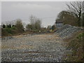
Wedge Tomb in Co. Clare
This tomb is not very attractive (a stone wall has been built against it) but is included because of its accessibility. It displays the characteristic wedge-shape of these tombs. A long chamber of 5 stones supports 2 roofstones.
Note: Photo © Anthony Weir
You may be viewing yesterday's version of this page. To see the most up to date information please register for a free account.
Do not use the above information on other web sites or publications without permission of the contributor.
Nearby Images from Geograph Britain and Ireland:
©2019(licence)
©2021(licence)
©2005(licence)
©2012(licence)
The above images may not be of the site on this page, they are loaded from Geograph.
Please Submit an Image of this site or go out and take one for us!
Click here to see more info for this site
Nearby sites
Click here to view sites on an interactive map of the areaKey: Red: member's photo, Blue: 3rd party photo, Yellow: other image, Green: no photo - please go there and take one, Grey: site destroyed
Download sites to:
KML (Google Earth)
GPX (GPS waypoints)
CSV (Garmin/Navman)
CSV (Excel)
To unlock full downloads you need to sign up as a Contributory Member. Otherwise downloads are limited to 50 sites.
Turn off the page maps and other distractions
Nearby sites listing. In the following links * = Image available
8.1km SSE 156° Knockaroura* Stone Row / Alignment (R423803)
8.5km SW 216° Ballyallia Lake Stone Circle (R340810)
11.0km SE 135° Milltown Wedge Tomb* Wedge Tomb (R468799)
11.3km WSW 254° St Tola's High Cross (Dysert O'Dea) Ancient Cross
11.9km SSE 154° Magh Adair* Standing Stone (Menhir) (R441770)
12.5km WNW 287° Killinaboy Church Early Christian Sculptured Stone (R27139158)
13.0km NW 319° Cappaghkennedy* Wedge Tomb (R307978)
13.1km NW 312° Slievenaglasha* Wedge Tomb (R295968)
13.6km NW 310° Tullycommon* Wedge Tomb (R287966)
13.6km WNW 296° Commons North 1* Wedge Tomb (R269940)
13.6km WNW 296° Commons North 2* Wedge Tomb (R269940)
13.8km WNW 294° Parknabinnia* Wedge Tomb (R26489357)
13.9km NW 308° Cahercommaun* Hillfort (R282965)
14.1km NW 314° Castletown Souterrain* Souterrain (Fogou, Earth House) (R291978)
14.1km WNW 292° Parknabinnia 2* Wedge Tomb (R26069331)
14.1km WNW 304° Creevagh* Wedge Tomb (R274958)
14.2km NW 314° Castletown Wedge Tomb* Wedge Tomb (R290978)
14.3km WNW 292° Parknabinnia Capstone Factory* Ancient Mine, Quarry or other Industry (R259933)
14.3km WNW 293° Parknabinnia Court Tomb* Court Tomb (R2602193585)
14.3km WNW 292° Parknabinnia 4* Wedge Tomb (R25889326)
14.4km WNW 292° Parknabinnia 1* Wedge Tomb (R25749341)
15.1km ESE 112° Rosslara* Wedge Tomb (R531819)
16.7km SSE 161° Knappogue* Standing Stones (R443719)
17.2km NW 309° Meggagh* Wedge Tomb (R258988)
17.3km ESE 116° Coolbaun* Burial Chamber or Dolmen (R546800)
View more nearby sites and additional images


 We would like to know more about this location. Please feel free to add a brief description and any relevant information in your own language.
 Wir möchten mehr über diese Stätte erfahren. Bitte zögern Sie nicht, eine kurze Beschreibung und relevante Informationen in Deutsch hinzuzufügen.
 Nous aimerions en savoir encore un peu sur les lieux. S'il vous plaît n'hesitez pas à ajouter une courte description et tous les renseignements pertinents dans votre propre langue.
 Quisieramos informarnos un poco más de las lugares. No dude en añadir una breve descripción y otros datos relevantes en su propio idioma.