


<< Text Pages >> Farranmacbride - Court Tomb in Ireland (Republic of) in Co. Donegal
Submitted by Anthony_Weir on Sunday, 13 October 2002 Page Views: 5719
Neolithic and Bronze AgeSite Name: Farranmacbride Alternative Name: Munnernamortee CaveCountry: Ireland (Republic of) County: Co. Donegal Type: Court Tomb
Nearest Village: Glencolumbcille
Map Ref: G534854
Discovery Map Number: D10
Latitude: 54.714465N Longitude: 8.723796W
Condition:
| 5 | Perfect |
| 4 | Almost Perfect |
| 3 | Reasonable but with some damage |
| 2 | Ruined but still recognisable as an ancient site |
| 1 | Pretty much destroyed, possibly visible as crop marks |
| 0 | No data. |
| -1 | Completely destroyed |
| 5 | Superb |
| 4 | Good |
| 3 | Ordinary |
| 2 | Not Good |
| 1 | Awful |
| 0 | No data. |
| 5 | Can be driven to, probably with disabled access |
| 4 | Short walk on a footpath |
| 3 | Requiring a bit more of a walk |
| 2 | A long walk |
| 1 | In the middle of nowhere, a nightmare to find |
| 0 | No data. |
| 5 | co-ordinates taken by GPS or official recorded co-ordinates |
| 4 | co-ordinates scaled from a detailed map |
| 3 | co-ordinates scaled from a bad map |
| 2 | co-ordinates of the nearest village |
| 1 | co-ordinates of the nearest town |
| 0 | no data |
Internal Links:
External Links:
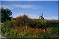
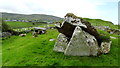
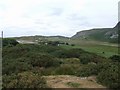
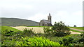
Court Tomb in Co. Donegal. Glencolumbcille is famous for its turas, or devotional pattern on the 9th of June, along a given route which is punctuated by stations. Most of the stations feature beautiful early-christian cross-slabs and cairns, but two are in fact megalithic tombs. The one in Farranmacbride (the ninth station, 400 metres N of the church of Glencolumbcille) , close to a perforated standing-stone "through which Heaven may be glimpsed" by the pure - or devout - "and barren women made fertile", is a huge ruined court-tomb, some of whose chambers have been used as livestock pens. Two large twin-chambered galleries open on to a central court about 21 metres in diameter (the longest in Ireland) - most of whose orthostats are missing. The SW area of the court is crossed by a sunken track. Three subsidiary chambers are set around the court, occurring more or less where the façades of facing single-court tombs would have ended. This tombs seems to be one of the many "experimental" or "culturally-diverse" in the NW, and has some similarities with those at Tullyskeherny in county Leitrim.
You may be viewing yesterday's version of this page. To see the most up to date information please register for a free account.
Do not use the above information on other web sites or publications without permission of the contributor.
Nearby Images from Geograph Britain and Ireland:
©2005(licence)
©2019(licence)
©2010(licence)
©2016(licence)
©2019(licence)
The above images may not be of the site on this page, they are loaded from Geograph.
Please Submit an Image of this site or go out and take one for us!
Click here to see more info for this site
Nearby sites
Click here to view sites on an interactive map of the areaKey: Red: member's photo, Blue: 3rd party photo, Yellow: other image, Green: no photo - please go there and take one, Grey: site destroyed
Download sites to:
KML (Google Earth)
GPX (GPS waypoints)
CSV (Garmin/Navman)
CSV (Excel)
To unlock full downloads you need to sign up as a Contributory Member. Otherwise downloads are limited to 50 sites.
Turn off the page maps and other distractions
Nearby sites listing. In the following links * = Image available
3.2km SSW 208° Cloghanmore Court Tomb* Court Tomb (G5189182601)
7.0km SSW 211° Dun Alt Promontory Fort* Promontory Fort / Cliff Castle (G497794)
7.5km ESE 110° Stranakirke Dolmen* Modern Stone Circle etc
15.2km SE 132° Croaghbeg Court Tomb (G646751)
15.2km SE 131° Shalwy* Court Tomb (G6480975310)
15.4km SE 129° St.Ciaran's Holy Well* Holy Well or Sacred Spring (G652755)
20.0km ESE 104° Carricknamoghil* Court Tomb
20.8km NE 52° Doon Fort* Stone Fort or Dun (G700980)
21.4km ENE 58° Kilclooney Court Tomb* Court Tomb (G717967)
21.9km ENE 58° Kilclooney More II* Portal Tomb (G7220796721)
23.0km NE 50° St Connell's Churchyard (Inishkeel)* Ancient Cross (B711001)
30.6km E 91° Lettermore Stone Circle (G841847)
35.9km SSE 148° Creevykeel* Court Tomb (G7192054549)
40.7km S 176° Knocklane* Promontory Fort / Cliff Castle
41.0km ESE 120° Twomilestone Standing Stone (Menhir) (G890648)
42.4km SE 146° Tievebaun Burial Chamber or Dolmen
45.3km ESE 119° Creevery Upper* Chambered Tomb (G92766277)
46.1km NE 37° Cnoc a' Stolaire 1* Standing Stone (Menhir)
46.5km S 170° Saint Patrick's Chair (Coney Island)* Natural Stone / Erratic / Other Natural Feature (G61353951)
48.5km SSE 146° Dartry* Wedge Tomb (G799447)
49.5km S 171° Sligo Airport* Chambered Tomb (G61073641)
50.2km SE 134° Shasgar* Court Tomb (G896504)
51.5km S 169° Knocknarea-North* Passage Grave (G62613470)
51.6km S 169° Knocknarea* Passage Grave (G6260434583)
52.3km SSE 161° Abbeyquarter* Chambered Tomb (G7002835741)
View more nearby sites and additional images


 We would like to know more about this location. Please feel free to add a brief description and any relevant information in your own language.
 Wir möchten mehr über diese Stätte erfahren. Bitte zögern Sie nicht, eine kurze Beschreibung und relevante Informationen in Deutsch hinzuzufügen.
 Nous aimerions en savoir encore un peu sur les lieux. S'il vous plaît n'hesitez pas à ajouter une courte description et tous les renseignements pertinents dans votre propre langue.
 Quisieramos informarnos un poco más de las lugares. No dude en añadir una breve descripción y otros datos relevantes en su propio idioma.