

<< Our Photo Pages >> Anta da Arca - Burial Chamber or Dolmen in Portugal in Viseu
Submitted by FilipeCsilva on Wednesday, 09 November 2011 Page Views: 2954
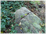
Neolithic and Bronze AgeSite Name: Anta da Arca Alternative Name: Anta do Espírito Santo D'ArcaCountry: Portugal
NOTE: This site is 11.391 km away from the location you searched for.
Distrito: Viseu Type: Burial Chamber or Dolmen
Nearest Town: Caramulo Nearest Village: Arca
Latitude: 40.607700N Longitude: 8.21355W
Condition:
| 5 | Perfect |
| 4 | Almost Perfect |
| 3 | Reasonable but with some damage |
| 2 | Ruined but still recognisable as an ancient site |
| 1 | Pretty much destroyed, possibly visible as crop marks |
| 0 | No data. |
| -1 | Completely destroyed |
| 5 | Superb |
| 4 | Good |
| 3 | Ordinary |
| 2 | Not Good |
| 1 | Awful |
| 0 | No data. |
| 5 | Can be driven to, probably with disabled access |
| 4 | Short walk on a footpath |
| 3 | Requiring a bit more of a walk |
| 2 | A long walk |
| 1 | In the middle of nowhere, a nightmare to find |
| 0 | No data. |
| 5 | co-ordinates taken by GPS or official recorded co-ordinates |
| 4 | co-ordinates scaled from a detailed map |
| 3 | co-ordinates scaled from a bad map |
| 2 | co-ordinates of the nearest village |
| 1 | co-ordinates of the nearest town |
| 0 | no data |
Internal Links:
External Links:
I have visited· I would like to visit
rrmoser would like to visit
")
Info provided by FilipeCsilva, 2011.
Though situated on a mountain it is easily accessible by car. Has a few lights around it confering a nice glow at night. It is well worth the visit as a few miles from this site there is a car museum (Museu do Caramulo) with about 60 cars - all in working order - from the very end of the 19th Century to the 80's.
You may be viewing yesterday's version of this page. To see the most up to date information please register for a free account.
")
")
")
")
")
")
")
")
")
")
")
")
Do not use the above information on other web sites or publications without permission of the contributor.
Click here to see more info for this site
Nearby sites
Click here to view sites on an interactive map of the areaKey: Red: member's photo, Blue: 3rd party photo, Yellow: other image, Green: no photo - please go there and take one, Grey: site destroyed
Download sites to:
KML (Google Earth)
GPX (GPS waypoints)
CSV (Garmin/Navman)
CSV (Excel)
To unlock full downloads you need to sign up as a Contributory Member. Otherwise downloads are limited to 50 sites.
Turn off the page maps and other distractions
Nearby sites listing. In the following links * = Image available
7.3km ENE 59° Dólmen da Lapa da Meruge* Burial Chamber or Dolmen
10.4km NW 307° Dólmen de Chão Redondo 1* Burial Chamber or Dolmen
10.4km NW 307° Dólmen de Chão Redondo 2* Burial Chamber or Dolmen
10.5km NNE 19° Castro do Cabeço do Couço Castro or Chafurdão
10.9km NW 320° Anta da Sepultura do Rei Chambered Tomb
11.1km NW 309° Anta do Poço dos Mouros Passage Grave
11.2km ENE 75° Estela Menir da Caparrosa* Standing Stone (Menhir)
11.2km NE 44° Dólmen da Malhada do Cambarinho* Burial Chamber or Dolmen
11.9km N 350° Mamoa do Vale do Cando Round Cairn
11.9km N 359° Mamoa 1 do Vale do Ruivo Round Cairn
11.9km NNW 348° Anta Pintada de Antelas* Burial Chamber or Dolmen
12.0km N 353° Mamoa do Paul* Round Cairn
12.0km N 358° Mamoa 2 do Vale do Ruivo Round Cairn
12.0km NW 321° Anta da Capela dos Mouros* Burial Chamber or Dolmen
12.1km N 355° Mamoa da Cumeeira Round Cairn
12.1km N 357° Mamoa 4 do Vale do Ruivo Round Cairn
12.4km NNW 347° Mamoa 1 da Pedra da Broa* Round Cairn
12.5km ESE 120° Castro de Nandunfe Castro or Chafurdão
12.5km NNW 347° Mamoa 2 da Pedra da Broa* Round Cairn
13.1km NNE 32° Castro de Paços de Vilharigues Castro or Chafurdão
19.1km NW 316° Dólmen do Souto do Coval 2 Burial Chamber or Dolmen
19.1km NW 316° Dólmen do Souto do Coval 1 Burial Chamber or Dolmen
19.7km NNE 30° Castro de Nossa Senhora da Guia Castro or Chafurdão
20.5km ESE 122° Anta da Arquinha da Moura* Burial Chamber or Dolmen
20.8km NNW 337° Anta da Cerqueira* Burial Chamber or Dolmen
View more nearby sites and additional images


 We would like to know more about this location. Please feel free to add a brief description and any relevant information in your own language.
 Wir möchten mehr über diese Stätte erfahren. Bitte zögern Sie nicht, eine kurze Beschreibung und relevante Informationen in Deutsch hinzuzufügen.
 Nous aimerions en savoir encore un peu sur les lieux. S'il vous plaît n'hesitez pas à ajouter une courte description et tous les renseignements pertinents dans votre propre langue.
 Quisieramos informarnos un poco más de las lugares. No dude en añadir una breve descripción y otros datos relevantes en su propio idioma.