


<< Our Photo Pages >> Dartry - Wedge Tomb in Ireland (Republic of) in Co. Sligo
Submitted by Anthony_Weir on Sunday, 13 October 2002 Page Views: 5057
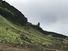
Neolithic and Bronze AgeSite Name: DartryCountry: Ireland (Republic of) County: Co. Sligo Type: Wedge Tomb
Nearest Town: Sligo Nearest Village: Manorhamilton
Map Ref: G799447
Discovery Map Number: D16
Latitude: 54.350610N Longitude: 8.309854W
Condition:
| 5 | Perfect |
| 4 | Almost Perfect |
| 3 | Reasonable but with some damage |
| 2 | Ruined but still recognisable as an ancient site |
| 1 | Pretty much destroyed, possibly visible as crop marks |
| 0 | No data. |
| -1 | Completely destroyed |
| 5 | Superb |
| 4 | Good |
| 3 | Ordinary |
| 2 | Not Good |
| 1 | Awful |
| 0 | No data. |
| 5 | Can be driven to, probably with disabled access |
| 4 | Short walk on a footpath |
| 3 | Requiring a bit more of a walk |
| 2 | A long walk |
| 1 | In the middle of nowhere, a nightmare to find |
| 0 | No data. |
| 5 | co-ordinates taken by GPS or official recorded co-ordinates |
| 4 | co-ordinates scaled from a detailed map |
| 3 | co-ordinates scaled from a bad map |
| 2 | co-ordinates of the nearest village |
| 1 | co-ordinates of the nearest town |
| 0 | no data |
Internal Links:
External Links:
")
Situated on the gradual W slope of Truskmore Mountain, this is one of several megalithic tombs to be discovered recently. It is an almost-intact wedge-tomb with all the classic characteristics of kerb, double-walling and portico/antechamber, though the entrance is still hidden in peat.
~ Just over 11 kms NE is the well-preserved court-tomb at Shasgar, county Leitrim.
Note: Photo © Anthony Weir
You may be viewing yesterday's version of this page. To see the most up to date information please register for a free account.
")
Do not use the above information on other web sites or publications without permission of the contributor.
Nearby Images from Flickr

The above images may not be of the site on this page, but were taken nearby. They are loaded from Flickr so please click on them for image credits.
Click here to see more info for this site
Nearby sites
Click here to view sites on an interactive map of the areaKey: Red: member's photo, Blue: 3rd party photo, Yellow: other image, Green: no photo - please go there and take one, Grey: site destroyed
Download sites to:
KML (Google Earth)
GPX (GPS waypoints)
CSV (Garmin/Navman)
CSV (Excel)
To unlock full downloads you need to sign up as a Contributory Member. Otherwise downloads are limited to 50 sites.
Turn off the page maps and other distractions
Nearby sites listing. In the following links * = Image available
6.1km NNW 330° Tievebaun Burial Chamber or Dolmen
9.2km SSW 210° Magheraghanrush* Court Tomb (G753367)
11.2km ENE 59° Shasgar* Court Tomb (G896504)
12.7km NW 321° Creevykeel* Court Tomb (G7192054549)
13.3km SW 227° Abbeyquarter* Chambered Tomb (G7002835741)
17.2km E 82° Kilcoo Stone Circle (G970470)
17.3km SW 231° Carrowmore 13* Burial Chamber or Dolmen
17.3km SW 231° Carrowmore 7* Passage Grave (G663339)
17.4km SW 230° Carrowmore 18* Passage Grave
17.4km SW 231° Carrowmore 59* Burial Chamber or Dolmen
17.5km SW 231° Carrowmore 5.* Passage Grave (G662338)
17.5km SW 231° Carrowmore* Passage Grave (G6621633706)
17.5km SW 231° Carrowmore 4.* Passage Grave (G662337)
17.5km SW 231° Carrowmore 1.* Passage Grave
17.6km SW 229° Carrowmore 27* Passage Grave
17.6km SW 230° Carrowmore 26* Stone Circle (G663335)
17.6km SW 230° Carrowmore 11* Stone Circle (G663335)
17.6km SW 230° Carrowmore 9* Stone Circle (G663335)
17.6km SW 231° Carrowmore 54* Passage Grave (G662336)
17.6km SW 231° Carrowmore 55* Passage Grave (G662336)
17.6km SW 231° Carrowmore 52* Passage Grave (G662336)
17.6km SW 231° Carrowmore 2.* Passage Grave (G661337)
17.7km SW 230° Carrowmore 57* Stone Circle (G662335)
17.7km SW 230° Carrowmore 57 Passage Grave (G662335)
17.7km SW 230° Carrowmore 51 (Listoghil)* Passage Grave (G66243345)
View more nearby sites and additional images


 We would like to know more about this location. Please feel free to add a brief description and any relevant information in your own language.
 Wir möchten mehr über diese Stätte erfahren. Bitte zögern Sie nicht, eine kurze Beschreibung und relevante Informationen in Deutsch hinzuzufügen.
 Nous aimerions en savoir encore un peu sur les lieux. S'il vous plaît n'hesitez pas à ajouter une courte description et tous les renseignements pertinents dans votre propre langue.
 Quisieramos informarnos un poco más de las lugares. No dude en añadir una breve descripción y otros datos relevantes en su propio idioma.