

<< Our Photo Pages >> Corracloona - Court Tomb in Ireland (Republic of) in Co. Leitrim
Submitted by Anthony_Weir on Sunday, 13 October 2002 Page Views: 8293
Neolithic and Bronze AgeSite Name: CorracloonaCountry: Ireland (Republic of)
NOTE: This site is 6.365 km away from the location you searched for.
County: Co. Leitrim Type: Court Tomb
Nearest Town: Glenfarne Nearest Village: Kiltyclogher
Map Ref: G997428
Discovery Map Number: D17
Latitude: 54.333938N Longitude: 8.005357W
Condition:
| 5 | Perfect |
| 4 | Almost Perfect |
| 3 | Reasonable but with some damage |
| 2 | Ruined but still recognisable as an ancient site |
| 1 | Pretty much destroyed, possibly visible as crop marks |
| 0 | No data. |
| -1 | Completely destroyed |
| 5 | Superb |
| 4 | Good |
| 3 | Ordinary |
| 2 | Not Good |
| 1 | Awful |
| 0 | No data. |
| 5 | Can be driven to, probably with disabled access |
| 4 | Short walk on a footpath |
| 3 | Requiring a bit more of a walk |
| 2 | A long walk |
| 1 | In the middle of nowhere, a nightmare to find |
| 0 | No data. |
| 5 | co-ordinates taken by GPS or official recorded co-ordinates |
| 4 | co-ordinates scaled from a detailed map |
| 3 | co-ordinates scaled from a bad map |
| 2 | co-ordinates of the nearest village |
| 1 | co-ordinates of the nearest town |
| 0 | no data |
Internal Links:
External Links:
")
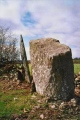
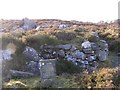
The hole does not seem to be artificial, but that does not mean that it was not a perhaps-serendipitous choice. The door-stone is very much like the septal slab of wedge-tombs, and the gallery has just one chamber (like a southern French ‘dolmen’), which makes the monument either hybrid or experimental in an area of much megalithic activity.
You may be viewing yesterday's version of this page. To see the most up to date information please register for a free account.
Do not use the above information on other web sites or publications without permission of the contributor.
Nearby Images from Geograph Britain and Ireland:
©2009(licence)
©2009(licence)
©2009(licence)
©2009(licence)
©2009(licence)
The above images may not be of the site on this page, they are loaded from Geograph.
Please Submit an Image of this site or go out and take one for us!
Click here to see more info for this site
Nearby sites
Click here to view sites on an interactive map of the areaKey: Red: member's photo, Blue: 3rd party photo, Yellow: other image, Green: no photo - please go there and take one, Grey: site destroyed
Download sites to:
KML (Google Earth)
GPX (GPS waypoints)
CSV (Garmin/Navman)
CSV (Excel)
To unlock full downloads you need to sign up as a Contributory Member. Otherwise downloads are limited to 50 sites.
Turn off the page maps and other distractions
Nearby sites listing. In the following links * = Image available
3.4km ESE 104° Corraderrybrock Stone Circle (H030420)
5.0km NNW 327° Kilcoo Stone Circle (G970470)
6.3km E 101° Cloghastuckane Stone Circle (H059416)
6.4km ESE 102° Toppan Stone Circle (H060415)
7.0km ESE 114° Kilrooskagh Portal Tomb (H06143998)
7.9km SE 129° Killinagh* Rock Art (H059378)
7.9km SE 129° St Brigid' Stones Stone Row / Alignment (H059378)
8.2km NNE 16° Skaghlea Cairn Court Tomb (H01985070)
8.7km ESE 109° Cloghbrack Stone Circle (H080400)
9.9km E 86° Aghanaglack Court Tomb (H096435)
10.5km NE 43° Rossinure Beg Court Tomb (H06915053)
10.8km SE 135° Calf house Portal Tomb* Portal Tomb (H0729535148)
10.8km SE 135° Boulder Grave* Chambered Tomb
10.8km SE 134° Tullygobban Wedge Tomb* Wedge Tomb (H0743435259)
10.8km SE 145° Moneygashel* Stone Fort or Dun (H0594933908)
11.0km NE 46° Rossinure More Court Tomb (H07715039)
11.1km SE 133° Giants Leap Wedge Tomb* Wedge Tomb (H0787435232)
11.1km SE 137° Boulder Monument PB46* Natural Stone / Erratic / Other Natural Feature (H0731934670)
11.1km SE 137° Boulder Monument PB48* Natural Stone / Erratic / Other Natural Feature (H0733234670)
11.3km NE 41° Doagh Glebe Promontory Fort / Cliff Castle (H0709051350)
12.6km NW 307° Shasgar* Court Tomb (G896504)
12.7km E 84° Reyfad Stones Stone Row / Alignment (H124442)
12.8km SE 133° The Dumbies Court Tomb (H09123413)
14.3km SE 128° Tromogagh Stone Circle (H110340)
15.1km ENE 75° Ross Lough Crannog (H14294677)
View more nearby sites and additional images


 We would like to know more about this location. Please feel free to add a brief description and any relevant information in your own language.
 Wir möchten mehr über diese Stätte erfahren. Bitte zögern Sie nicht, eine kurze Beschreibung und relevante Informationen in Deutsch hinzuzufügen.
 Nous aimerions en savoir encore un peu sur les lieux. S'il vous plaît n'hesitez pas à ajouter une courte description et tous les renseignements pertinents dans votre propre langue.
 Quisieramos informarnos un poco más de las lugares. No dude en añadir una breve descripción y otros datos relevantes en su propio idioma.