


<< Text Pages >> Pastoruri Road - Rock Art in Peru
Submitted by davidmorgan on Friday, 07 December 2018 Page Views: 838
Rock ArtSite Name: Pastoruri Road Alternative Name: Carretera a PastoruriCountry: Peru
NOTE: This site is 30.82 km away from the location you searched for.
Type: Rock Art
Nearest Town: Recuay
Latitude: 9.88484S Longitude: 77.2345W
Condition:
| 5 | Perfect |
| 4 | Almost Perfect |
| 3 | Reasonable but with some damage |
| 2 | Ruined but still recognisable as an ancient site |
| 1 | Pretty much destroyed, possibly visible as crop marks |
| 0 | No data. |
| -1 | Completely destroyed |
| 5 | Superb |
| 4 | Good |
| 3 | Ordinary |
| 2 | Not Good |
| 1 | Awful |
| 0 | No data. |
| 5 | Can be driven to, probably with disabled access |
| 4 | Short walk on a footpath |
| 3 | Requiring a bit more of a walk |
| 2 | A long walk |
| 1 | In the middle of nowhere, a nightmare to find |
| 0 | No data. |
| 5 | co-ordinates taken by GPS or official recorded co-ordinates |
| 4 | co-ordinates scaled from a detailed map |
| 3 | co-ordinates scaled from a bad map |
| 2 | co-ordinates of the nearest village |
| 1 | co-ordinates of the nearest town |
| 0 | no data |
Internal Links:
External Links:
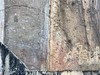
Rock Art in Ancash Region, Peru
Cave paintings beside the AN-1251 Carretera a Pastoruri in the Huascarán national park.
You may be viewing yesterday's version of this page. To see the most up to date information please register for a free account.
Do not use the above information on other web sites or publications without permission of the contributor.
Nearby Images from Flickr


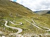
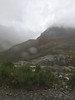
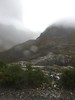
The above images may not be of the site on this page, but were taken nearby. They are loaded from Flickr so please click on them for image credits.
Click here to see more info for this site
Nearby sites
Click here to view sites on an interactive map of the areaKey: Red: member's photo, Blue: 3rd party photo, Yellow: other image, Green: no photo - please go there and take one, Grey: site destroyed
Download sites to:
KML (Google Earth)
GPX (GPS waypoints)
CSV (Garmin/Navman)
CSV (Excel)
To unlock full downloads you need to sign up as a Contributory Member. Otherwise downloads are limited to 50 sites.
Turn off the page maps and other distractions
Nearby sites listing. In the following links * = Image available
33.1km N 11° Chavín de Huantar* Ancient Village or Settlement
46.0km E 89° Wanuku Pampa* Ancient Village or Settlement
51.0km NW 321° Museo Regional de Áncash Museum
53.3km NW 326° Ichik Willkawain* Chambered Tomb
54.0km NW 326° Willkawain* Chambered Tomb
57.5km ENE 72° Saway Ancient Village or Settlement
65.8km ENE 77° Castillo de Chupan Ancient Palace
70.7km ENE 77° Mancopa Ancient Village or Settlement
77.9km SW 222° Shaura Ancient Village or Settlement
80.1km NE 48° Susupillo Hillfort
80.5km SW 222° Cerro de la Cruz Ancient Village or Settlement
80.5km NE 46° Piruro Hillfort
88.5km SW 220° Huaricanga Artificial Mound
91.9km WNW 295° Pallka Ancient Village or Settlement
92.2km NW 326° Guitarrero Cave* Cave or Rock Shelter
97.1km SW 216° Cerro Blanco 2 Ancient Village or Settlement
97.3km SSW 208° Huayto Ancient Village or Settlement
98.0km SW 216° Cerro Blanco 1 Ancient Village or Settlement
99.3km SW 217° Caballete Ancient Village or Settlement
99.6km WSW 259° El Castillo de Huarmey* Pyramid / Mastaba
100.6km SSW 211° Pampa San José Ancient Village or Settlement
101.0km SSW 211° Carreteria Ancient Village or Settlement
102.7km SW 216° Cerro Lampay Ancient Village or Settlement
102.7km SSW 209° Vinto Alto Ancient Village or Settlement
104.1km SSW 212° Upaca Ancient Village or Settlement
View more nearby sites and additional images


 We would like to know more about this location. Please feel free to add a brief description and any relevant information in your own language.
 Wir möchten mehr über diese Stätte erfahren. Bitte zögern Sie nicht, eine kurze Beschreibung und relevante Informationen in Deutsch hinzuzufügen.
 Nous aimerions en savoir encore un peu sur les lieux. S'il vous plaît n'hesitez pas à ajouter une courte description et tous les renseignements pertinents dans votre propre langue.
 Quisieramos informarnos un poco más de las lugares. No dude en añadir una breve descripción y otros datos relevantes en su propio idioma.