 with our Megalithic Portal iPhone app")


<< Text Pages >> Cantamarca - Ancient Village or Settlement in Peru
Submitted by davidmorgan on Tuesday, 23 February 2016 Page Views: 992
Multi-periodSite Name: CantamarcaCountry: Peru
NOTE: This site is 53.079 km away from the location you searched for.
Type: Ancient Village or Settlement
Nearest Town: Canta
Latitude: 11.438551S Longitude: 76.590019W
Condition:
| 5 | Perfect |
| 4 | Almost Perfect |
| 3 | Reasonable but with some damage |
| 2 | Ruined but still recognisable as an ancient site |
| 1 | Pretty much destroyed, possibly visible as crop marks |
| 0 | No data. |
| -1 | Completely destroyed |
| 5 | Superb |
| 4 | Good |
| 3 | Ordinary |
| 2 | Not Good |
| 1 | Awful |
| 0 | No data. |
| 5 | Can be driven to, probably with disabled access |
| 4 | Short walk on a footpath |
| 3 | Requiring a bit more of a walk |
| 2 | A long walk |
| 1 | In the middle of nowhere, a nightmare to find |
| 0 | No data. |
| 5 | co-ordinates taken by GPS or official recorded co-ordinates |
| 4 | co-ordinates scaled from a detailed map |
| 3 | co-ordinates scaled from a bad map |
| 2 | co-ordinates of the nearest village |
| 1 | co-ordinates of the nearest town |
| 0 | no data |
Internal Links:
External Links:
Ancient Settlement in Lima Region, Peru
The main town of the Canta chiefdom in the Rio Chillón valley during the Late Intermediate period (1000-1450 CE).
Several circular structures have been erected on the slope of a hill. There are also many later Inca square structures.
More information at Arqueología del Perú (in Spanish).
You may be viewing yesterday's version of this page. To see the most up to date information please register for a free account.
Do not use the above information on other web sites or publications without permission of the contributor.
Nearby Images from Flickr
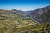
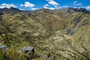
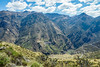
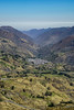
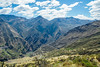
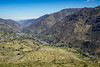
The above images may not be of the site on this page, but were taken nearby. They are loaded from Flickr so please click on them for image credits.
Click here to see more info for this site
Nearby sites
Click here to view sites on an interactive map of the areaKey: Red: member's photo, Blue: 3rd party photo, Yellow: other image, Green: no photo - please go there and take one, Grey: site destroyed
Download sites to:
KML (Google Earth)
GPX (GPS waypoints)
CSV (Garmin/Navman)
CSV (Excel)
To unlock full downloads you need to sign up as a Contributory Member. Otherwise downloads are limited to 50 sites.
Turn off the page maps and other distractions
Nearby sites listing. In the following links * = Image available
37.4km SW 221° Checta Rock Art
39.0km S 177° Marcahuasi Natural Stone / Erratic / Other Natural Feature
52.5km SW 232° Temple of the Fox Ancient Temple
81.2km SW 225° El Paraiso* Ancient Temple
87.6km SW 216° Museo Nacional de Arqueología Antropología e Historia del Peru* Museum
87.8km SW 217° Museo Arqueologico Rafael Larco Herrera* Museum
88.2km SW 214° Huaca Huallamarca* Pyramid / Mastaba
88.9km SSW 213° Huaca Pucllana* Pyramid / Mastaba
89.0km SW 216° Huaca Huantille* Pyramid / Mastaba
97.0km SSW 200° Pachacamac* Ancient Temple
104.5km NW 306° Jaiva Ancient Village or Settlement
104.5km NW 305° Capilla Ancient Village or Settlement
107.5km WNW 301° Peñico Ancient Village or Settlement
108.5km WNW 302° Huacache Ancient Village or Settlement
112.4km WNW 284° Bandurria* Ancient Village or Settlement
116.0km WNW 302° Llaqta Ancient Village or Settlement
118.3km WNW 301° Caral* Ancient Village or Settlement
118.5km WNW 301° Allpacoto Ancient Village or Settlement
119.5km WNW 301° Chupacigarro Ancient Village or Settlement
120.5km WNW 301° Cerro Colorado Ancient Village or Settlement
120.6km WNW 301° Miraya Ancient Village or Settlement
122.0km WNW 301° Lurihuasi Ancient Village or Settlement
122.5km WNW 301° Pueblo Nuevo Ancient Village or Settlement
122.7km WNW 292° Vichama* Ancient Village or Settlement
125.3km WNW 301° Pando Ancient Village or Settlement
View more nearby sites and additional images


 We would like to know more about this location. Please feel free to add a brief description and any relevant information in your own language.
 Wir möchten mehr über diese Stätte erfahren. Bitte zögern Sie nicht, eine kurze Beschreibung und relevante Informationen in Deutsch hinzuzufügen.
 Nous aimerions en savoir encore un peu sur les lieux. S'il vous plaît n'hesitez pas à ajouter une courte description et tous les renseignements pertinents dans votre propre langue.
 Quisieramos informarnos un poco más de las lugares. No dude en añadir una breve descripción y otros datos relevantes en su propio idioma.