 with our Megalithic Portal iPhone app")


<< Our Photo Pages >> Intipata - Ancient Village or Settlement in Peru
Submitted by Ogham on Tuesday, 03 July 2012 Page Views: 4139
Multi-periodSite Name: IntipataCountry: Peru Type: Ancient Village or Settlement
Nearest Town: Aguas Calientes Nearest Village: Aguas Calientes
Latitude: 13.186616S Longitude: 72.540991W
Condition:
| 5 | Perfect |
| 4 | Almost Perfect |
| 3 | Reasonable but with some damage |
| 2 | Ruined but still recognisable as an ancient site |
| 1 | Pretty much destroyed, possibly visible as crop marks |
| 0 | No data. |
| -1 | Completely destroyed |
| 5 | Superb |
| 4 | Good |
| 3 | Ordinary |
| 2 | Not Good |
| 1 | Awful |
| 0 | No data. |
| 5 | Can be driven to, probably with disabled access |
| 4 | Short walk on a footpath |
| 3 | Requiring a bit more of a walk |
| 2 | A long walk |
| 1 | In the middle of nowhere, a nightmare to find |
| 0 | No data. |
| 5 | co-ordinates taken by GPS or official recorded co-ordinates |
| 4 | co-ordinates scaled from a detailed map |
| 3 | co-ordinates scaled from a bad map |
| 2 | co-ordinates of the nearest village |
| 1 | co-ordinates of the nearest town |
| 0 | no data |
Internal Links:
External Links:
I have visited· I would like to visit
Jansold visited on 1st Sep 2001 - their rating: Cond: 3 Amb: 5 Access: 2
Tdiver visited on 1st Jan 1991 - their rating: Cond: 2 Amb: 5 Access: 2
Ogham have visited here
Average ratings for this site from all visit loggers: Condition: 2.5 Ambience: 5 Access: 2
")
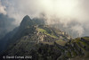
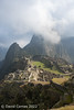
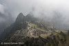
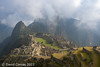
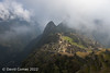
Intipata means “The Town of the Sun”. It’s an archaeological site formed mainly by agricultural terraces which have a convex shape. They were discovered by coincidence in 1992. The University of Cusco (UNSAAC) cleared the terraces and found there 5 small buildings. The ruin can be visited. A shortcut to the sanctuary of Machu Picchu existed in Inca times crossing Intipata. It is 3000m approximately above sea level and can only be accessed by walking up from Aguas Calientes or completing the Inka Trail.
Because there are no plazas, religious structures or fortifications, the experts have little doubt that Intipata was primarily an agricultural settlement. But it probably had a strategic function as well. From Intipata you can see across to the lookout platform on the top of Cerro Machu Picchu, and down to the Inca site of Choquesuysuy. Messages could be transmitted to the mountain city of Machu Picchu from the floor of the Urubamba below through the lookout point on the top of Intipata.
You may be viewing yesterday's version of this page. To see the most up to date information please register for a free account.
")
")
")
Do not use the above information on other web sites or publications without permission of the contributor.
Nearby Images from Flickr

The above images may not be of the site on this page, but were taken nearby. They are loaded from Flickr so please click on them for image credits.
Click here to see more info for this site
Nearby sites
Click here to view sites on an interactive map of the areaKey: Red: member's photo, Blue: 3rd party photo, Yellow: other image, Green: no photo - please go there and take one, Grey: site destroyed
Download sites to:
KML (Google Earth)
GPX (GPS waypoints)
CSV (Garmin/Navman)
CSV (Excel)
To unlock full downloads you need to sign up as a Contributory Member. Otherwise downloads are limited to 50 sites.
Turn off the page maps and other distractions
Nearby sites listing. In the following links * = Image available
817m SE 139° Winay Wayna* Ancient Village or Settlement
1.9km NNE 19° Intipunku* Ancient Temple
2.4km SSE 157° Phuyupatamarca* Ancient Village or Settlement
2.5km N 350° Machu Picchu.* Ancient Village or Settlement
4.6km N 351° Inkaraqay Ancient Village or Settlement
5.4km SSE 149° Sayacmarca* Ancient Village or Settlement
6.3km SE 137° Runkurakay* Ancient Village or Settlement
13.9km ESE 113° Llactapata* Ancient Village or Settlement
15.3km ESE 108° Salapunku* Ancient Village or Settlement
31.1km ESE 105° Ollantaytambo* Ancient Village or Settlement
33.1km ESE 114° Raqaypata* Ancient Village or Settlement
35.5km ESE 109° Ñaupa Iglesia* Ancient Temple
40.6km ESE 113° Moray Terraces* Misc. Earthwork
42.7km WSW 238° Choquequirao* Ancient Village or Settlement
43.6km ESE 107° Las Salinas* Ancient Mine, Quarry or other Industry
43.8km WNW 281° Ñusta Hispana* Holy Well or Sacred Spring
49.1km SW 215° Saihuite Stone* Sculptured Stone
58.2km ESE 113° Chinchero* Ancient Village or Settlement
58.2km ESE 113° Puma Temple* Ancient Temple
67.5km ESE 107° Huchuy Qosqo Ancient Village or Settlement
70.1km ESE 118° Tambomachay* Ancient Village or Settlement
70.3km ESE 121° Sacsayhuaman* Hillfort
70.4km ESE 119° Lanlakuyok Carving
70.8km ESE 118° Puca Pucara* Stone Fort or Dun
71.0km ESE 121° Cusco* Ancient Village or Settlement
View more nearby sites and additional images


 We would like to know more about this location. Please feel free to add a brief description and any relevant information in your own language.
 Wir möchten mehr über diese Stätte erfahren. Bitte zögern Sie nicht, eine kurze Beschreibung und relevante Informationen in Deutsch hinzuzufügen.
 Nous aimerions en savoir encore un peu sur les lieux. S'il vous plaît n'hesitez pas à ajouter une courte description et tous les renseignements pertinents dans votre propre langue.
 Quisieramos informarnos un poco más de las lugares. No dude en añadir una breve descripción y otros datos relevantes en su propio idioma.