
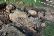

<< Other Photo Pages >> Aquis Querquennis Campamento Romano - Ancient Village or Settlement in Spain in Galicia
Submitted by holger_rix on Wednesday, 02 December 2015 Page Views: 2142
Multi-periodSite Name: Aquis Querquennis Campamento RomanoCountry: Spain
NOTE: This site is 6.426 km away from the location you searched for.
Region: Galicia Type: Ancient Village or Settlement
Nearest Village: Santa Comba
Latitude: 41.974030N Longitude: 7.98096W
Condition:
| 5 | Perfect |
| 4 | Almost Perfect |
| 3 | Reasonable but with some damage |
| 2 | Ruined but still recognisable as an ancient site |
| 1 | Pretty much destroyed, possibly visible as crop marks |
| 0 | No data. |
| -1 | Completely destroyed |
| 5 | Superb |
| 4 | Good |
| 3 | Ordinary |
| 2 | Not Good |
| 1 | Awful |
| 0 | No data. |
| 5 | Can be driven to, probably with disabled access |
| 4 | Short walk on a footpath |
| 3 | Requiring a bit more of a walk |
| 2 | A long walk |
| 1 | In the middle of nowhere, a nightmare to find |
| 0 | No data. |
| 5 | co-ordinates taken by GPS or official recorded co-ordinates |
| 4 | co-ordinates scaled from a detailed map |
| 3 | co-ordinates scaled from a bad map |
| 2 | co-ordinates of the nearest village |
| 1 | co-ordinates of the nearest town |
| 0 | no data |
Be the first person to rate this site - see the 'Contribute!' box in the right hand menu.
Internal Links:
External Links:
")
You may be viewing yesterday's version of this page. To see the most up to date information please register for a free account.
Do not use the above information on other web sites or publications without permission of the contributor.
Nearby Images from Flickr
The above images may not be of the site on this page, but were taken nearby. They are loaded from Flickr so please click on them for image credits.
Click here to see more info for this site
Nearby sites
Click here to view sites on an interactive map of the areaKey: Red: member's photo, Blue: 3rd party photo, Yellow: other image, Green: no photo - please go there and take one, Grey: site destroyed
Download sites to:
KML (Google Earth)
GPX (GPS waypoints)
CSV (Garmin/Navman)
CSV (Excel)
To unlock full downloads you need to sign up as a Contributory Member. Otherwise downloads are limited to 50 sites.
Turn off the page maps and other distractions
Nearby sites listing. In the following links * = Image available
426m SW 232° Pedrafita en Aquis Querquernis Standing Stone (Menhir)
6.1km SSE 148° Casiña da Moura* Burial Chamber or Dolmen
6.8km SSE 156° Casola do Foxo* Burial Chamber or Dolmen
7.5km SE 137° Necrópole de Outeiro de Cavaladre* Burial Chamber or Dolmen
11.5km W 279° Casa da Moura Dolmen (A Gurita)* Burial Chamber or Dolmen
12.0km NNW 338° Pedrafita das Catro Cruces Standing Stone (Menhir)
14.6km NW 318° Dolmen de Penagache* Burial Chamber or Dolmen
16.7km SW 219° Aquis Originis Ancient Village or Settlement
19.2km WNW 292° Porta de Lamas de Mouro* Museum
20.8km SE 142° Sepulturas antropomórficas de Donões* Rock Cut Tomb
20.8km N 1° Castro de Castromao* Castro or Chafurdão
21.6km WSW 237° Porta do Lindoso Museum
21.7km SE 133° Sepulturas antropomórficas de Santo Adrião* Rock Cut Tomb
22.1km SW 214° Portela do Homem* Modern Stone Circle etc
22.2km NNE 27° San Cibrao Dolmen 2 Burial Chamber or Dolmen
22.2km NNE 27° San Cibrao Dolmen 1 Burial Chamber or Dolmen
22.8km SE 137° Mamoas da Veiga Round Barrow(s)
23.2km SE 131° Montalegre* Modern Stone Circle etc
23.4km ENE 66° Castro da Cidade Castro or Chafurdão
23.9km W 275° Mamoa do Batateiro* Burial Chamber or Dolmen
24.3km SW 227° Necrópole Megalítica da Serra Amarela Barrow Cemetery
24.8km N 5° Petróglifo do Freixo Rock Art
25.2km NNW 340° Pía de Poulo Castro or Chafurdão
25.6km SSE 158° Castro de São Romão Castro or Chafurdão
27.3km ESE 109° Castro da Xironda Castro or Chafurdão
View more nearby sites and additional images


 We would like to know more about this location. Please feel free to add a brief description and any relevant information in your own language.
 Wir möchten mehr über diese Stätte erfahren. Bitte zögern Sie nicht, eine kurze Beschreibung und relevante Informationen in Deutsch hinzuzufügen.
 Nous aimerions en savoir encore un peu sur les lieux. S'il vous plaît n'hesitez pas à ajouter une courte description et tous les renseignements pertinents dans votre propre langue.
 Quisieramos informarnos un poco más de las lugares. No dude en añadir una breve descripción y otros datos relevantes en su propio idioma.