


<< Our Photo Pages >> Anta de Aguiar - Burial Chamber or Dolmen in Portugal in Évora
Submitted by Alta-Falisa on Wednesday, 07 May 2014 Page Views: 3898
Neolithic and Bronze AgeSite Name: Anta de Aguiar Alternative Name: Anta do Ferragial do AguiarCountry: Portugal
NOTE: This site is 0.853 km away from the location you searched for.
Distrito: Évora Type: Burial Chamber or Dolmen
Nearest Town: Viana do Alentejo Nearest Village: Aguiar
Latitude: 38.390550N Longitude: 7.969994W
Condition:
| 5 | Perfect |
| 4 | Almost Perfect |
| 3 | Reasonable but with some damage |
| 2 | Ruined but still recognisable as an ancient site |
| 1 | Pretty much destroyed, possibly visible as crop marks |
| 0 | No data. |
| -1 | Completely destroyed |
| 5 | Superb |
| 4 | Good |
| 3 | Ordinary |
| 2 | Not Good |
| 1 | Awful |
| 0 | No data. |
| 5 | Can be driven to, probably with disabled access |
| 4 | Short walk on a footpath |
| 3 | Requiring a bit more of a walk |
| 2 | A long walk |
| 1 | In the middle of nowhere, a nightmare to find |
| 0 | No data. |
| 5 | co-ordinates taken by GPS or official recorded co-ordinates |
| 4 | co-ordinates scaled from a detailed map |
| 3 | co-ordinates scaled from a bad map |
| 2 | co-ordinates of the nearest village |
| 1 | co-ordinates of the nearest town |
| 0 | no data |
Internal Links:
External Links:
I have visited· I would like to visit
Bak_teria visited on 23rd Jan 2016 - their rating: Cond: 3 Amb: 3 Access: 5
")
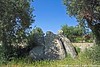
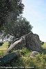
This monument is located at Aguiar, in the municipality of Viana do Alentejo of the Évora district.
The dolmen is partially destroyed, but the major components are still more or less in place, in any case still present, and the initial dolmen is recognizable, in particular the entrance corridor. This monument was built in the Neo-Chalcolithic period and is not yet classified.
About the access
Squeezed between the circular road turning around the village, in the middle of a few trees.
Signposted along Road R.254.
Nowadays there's also a small picnic park at site. Next to the monument you will find a table and some benches to sit.
Links and other information sources (all texts written in Portuguese):
- Portal do Arqueólogo
Texts and information by Alta-Falisa. Aditional info by Bak_teria.
You may be viewing yesterday's version of this page. To see the most up to date information please register for a free account.
")
")
")
Do not use the above information on other web sites or publications without permission of the contributor.
Nearby Images from Flickr


The above images may not be of the site on this page, but were taken nearby. They are loaded from Flickr so please click on them for image credits.
Click here to see more info for this site
Nearby sites
Click here to view sites on an interactive map of the areaKey: Red: member's photo, Blue: 3rd party photo, Yellow: other image, Green: no photo - please go there and take one, Grey: site destroyed
Download sites to:
KML (Google Earth)
GPX (GPS waypoints)
CSV (Garmin/Navman)
CSV (Excel)
To unlock full downloads you need to sign up as a Contributory Member. Otherwise downloads are limited to 50 sites.
Turn off the page maps and other distractions
Nearby sites listing. In the following links * = Image available
7.9km E 86° Anta da Herdade da Murteira Burial Chamber or Dolmen
10.0km NNE 14° Anta da Herdade do Zambujal Burial Chamber or Dolmen
11.7km SE 141° Villa de Mosteiros Ancient Village or Settlement
11.9km E 79° Anta da Herdade da Tisnada Burial Chamber or Dolmen
13.4km NNW 338° Villa de Nossa Senhora de Tourega* Ancient Village or Settlement
13.4km NNW 347° Anta Herdade do Barrocal 1* Burial Chamber or Dolmen
13.6km NNW 346° Anta do Barrocal 2* Burial Chamber or Dolmen
14.1km NW 326° Vale de Rodrigo 2* Burial Chamber or Dolmen
14.9km NNW 327° Vale de Rodrigo 3* Burial Chamber or Dolmen
15.5km NW 326° Conjunto Megalítico de Vale de Rodrigo* Barrow Cemetery
15.7km NNW 327° Vale de Rodrigo 1* Round Barrow(s)
16.5km NNW 347° Miliário da Mitra (Valverde)* Marker Stone
16.8km NE 37° Anta da Herdada do Vale de Moura 3* Burial Chamber or Dolmen
17.0km NNW 347° Anta Grande do Zambujeiro* Burial Chamber or Dolmen
17.2km NNW 346° Anta Pequena do Zambujeiro* Burial Chamber or Dolmen
17.2km NNW 341° Castelo do Giraldo* Castro or Chafurdão
18.1km NNE 25° Anta da Herdade das Azinheiras* Burial Chamber or Dolmen
18.7km NW 326° Anta Da Rocha 2 Burial Chamber or Dolmen
18.7km N 3° Menir 2 das Lajes* Standing Stone (Menhir)
19.0km NW 323° Marco Miliário de São Brissos* Marker Stone
19.1km NW 324° Anta Da Rocha 1 Burial Chamber or Dolmen
19.2km NNW 337° Menir no Vale dos Cardos Standing Stone (Menhir)
20.2km NNW 337° Cromeleque dos Almendres* Stone Circle
20.3km NNW 346° Centro Interpretativo dos Almendres* Museum
20.4km NW 317° Anta-Capela de Nossa Senhora do Livramento* Burial Chamber or Dolmen
View more nearby sites and additional images


 We would like to know more about this location. Please feel free to add a brief description and any relevant information in your own language.
 Wir möchten mehr über diese Stätte erfahren. Bitte zögern Sie nicht, eine kurze Beschreibung und relevante Informationen in Deutsch hinzuzufügen.
 Nous aimerions en savoir encore un peu sur les lieux. S'il vous plaît n'hesitez pas à ajouter une courte description et tous les renseignements pertinents dans votre propre langue.
 Quisieramos informarnos un poco más de las lugares. No dude en añadir una breve descripción y otros datos relevantes en su propio idioma.