


<< Our Photo Pages >> Mount drum archaeological site - Stone Circle in Ireland (Northern) in Co. Fermanagh
Submitted by LizH on Wednesday, 20 August 2008 Page Views: 8876
Neolithic and Bronze AgeSite Name: Mount drum archaeological siteCountry: Ireland (Northern)
NOTE: This site is 1.801 km away from the location you searched for.
County: Co. Fermanagh Type: Stone Circle
Nearest Town: Enniskillen Nearest Village: Lisbellaw
Map Ref: H306431
Latitude: 54.335718N Longitude: 7.530332W
Condition:
| 5 | Perfect |
| 4 | Almost Perfect |
| 3 | Reasonable but with some damage |
| 2 | Ruined but still recognisable as an ancient site |
| 1 | Pretty much destroyed, possibly visible as crop marks |
| 0 | No data. |
| -1 | Completely destroyed |
| 5 | Superb |
| 4 | Good |
| 3 | Ordinary |
| 2 | Not Good |
| 1 | Awful |
| 0 | No data. |
| 5 | Can be driven to, probably with disabled access |
| 4 | Short walk on a footpath |
| 3 | Requiring a bit more of a walk |
| 2 | A long walk |
| 1 | In the middle of nowhere, a nightmare to find |
| 0 | No data. |
| 5 | co-ordinates taken by GPS or official recorded co-ordinates |
| 4 | co-ordinates scaled from a detailed map |
| 3 | co-ordinates scaled from a bad map |
| 2 | co-ordinates of the nearest village |
| 1 | co-ordinates of the nearest town |
| 0 | no data |
Internal Links:
External Links:
I have visited· I would like to visit
Stone Free visited on 21st Apr 2015 - their rating: Cond: 2 Amb: 3 Access: 4
lizh have visited here
")
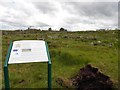
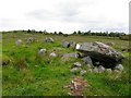
Mountdrum Archaelogical site is a publicly accessible set of sites on farmland near Enniskillen. The site comprises three stone circles with alignments and three tombs. The stone circles are all composed of low stones and are either indistinct or very indistinct in the peat.
Two of the stone circles in the bog were discovered in 1991 by Frederick Carroll, (according to his own letter to the Enniskillen Telegraph in 2007), but the land is apparently owned by the council to protect the archaeology but also the natural environment of bog (according to the Conservation volunteers). The sites were taken into public protection in 1995 (as above). However, it is still in active use as a farm, with some parts of the archaeology protected from the intrusion of farm animals. In 2007 the bog was cleared of scrub to allow stones to be seen, and it was then opened to the public.
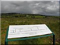
The information board on the site gives some information but it is of variable quality.
The board states that 'three stone circles and radial alignments can be seen to the east, while a further stone circle and two alignments can be viewed to the west'. Although there are three stone circles at Mountdrum, what this appears to mean is that one of the circles is concentric, with stones also between the inner and middle circles - and that a second is further to the west.
It continues
'In the east grouping, the inner circle is almost complete, except to the south, and is formed of small sandstone slabs, 12 slabs set radially to the centre are located between the inner circle and the middle circle. The middle circle survives as two arcs and is 7.1 metres across. Approximately one metre beyond the middle circle are the remains of the outer circle, an alignment of small orthostats extends radially for a distance of 30 m to the south east'.
It is quite difficult to see anything at all in the bog and grass, but the outline of the circle is visible, although I was not able to distinguish the outer circle or the alignment. The inner and middle circles can be outlined, the stones are only 6 inches or so high, and the grass is higher in many places, with some of the stones also substantially overgrown. It is possible to see some of the radial setting of the stones. This made it an unusual site which raised a question for me of what it really was.
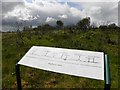
Just behind this, are the western circle and lines. These were even more difficult to see - I could see some orthostats, but again they were very low, and it was very difficult to see any links between them. I could just make out the outline of a possible circle, but the alignments were completely invisible. Since the description suggests that the stones are very widely spaced (six, for example, over 22 metres) this is perhaps less surprising. The information board says
'Approximately 35 m to the west of these circles is another which consists of small sandstone uprights standing 0.2-0.3 m above the bog. There appear to be two almost parallel alignments on the west side. The outer line is 17 m long and consists of six stones, the inner line is also composed of six stones and is 22 m long.'
The board then describes what may be a further alignment or a bigger part of a stone circle - I could not see it at all so cannot judge.
'A group of sandstone orthostats of a similar height to the north eastern alignment may be the arc of a stone circle but it is not certain. '
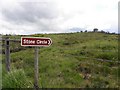
The site is easily accessible, from the minor road which goes around Topped mountain. It is not at all signposted from this road, and you have to go up a farm track (metalled) at 305 435, where it leads south. There is a carpark and you then walk to the sites. The circles and alignments described above are on the left hand side of the path (metalled track) through a gate. The other remains on this site (another stone circle and three tombs) are also described in other places (Mountdrum 2 and 3).
Editors and others; Please note; the map reference should read H306432 - I entered it wrongly because I'd already put up this site and asked a question about how to enter the site - it wouldn't let me re-enter with the same map ref. so I changed it - the other 'new site' for this doesn't say anything so is not very useful and should be deleted! But this map ref. is wrong by one figure; H306431 instead of H306432. Sorry if this wasn't sensible but it seemed the best thing to do at the time.
You may be viewing yesterday's version of this page. To see the most up to date information please register for a free account.
")
")
")
Do not use the above information on other web sites or publications without permission of the contributor.
Nearby Images from Geograph Britain and Ireland:
©2011(licence)
©2011(licence)
©2011(licence)
©2011(licence)
©2011(licence)
The above images may not be of the site on this page, they are loaded from Geograph.
Please Submit an Image of this site or go out and take one for us!
Click here to see more info for this site
Nearby sites
Click here to view sites on an interactive map of the areaKey: Red: member's photo, Blue: 3rd party photo, Yellow: other image, Green: no photo - please go there and take one, Grey: site destroyed
Download sites to:
KML (Google Earth)
GPX (GPS waypoints)
CSV (Garmin/Navman)
CSV (Excel)
To unlock full downloads you need to sign up as a Contributory Member. Otherwise downloads are limited to 50 sites.
Turn off the page maps and other distractions
Nearby sites listing. In the following links * = Image available
223m NNW 334° Mountdrum 3* Stone Circle (H305433)
400m N 0° Cavancarragh* Stone Row / Alignment (H306435)
499m N 0° Mount drum 2* Wedge Tomb (H306436)
1.9km NNW 339° Cavancarragh Multiple Stone Rows / Avenue (H299449)
1.9km NNW 339° Cavancarragh* Stone Circle (H299449)
2.9km N 8° Mullyknock Stone Circle (H3146)
2.9km N 8° Killee Stone Circle (H310460)
3.8km NE 40° Ratoran Stone Circle (H330460)
4.0km NNE 30° Ratoran Stone Row / Alignment
6.2km WNW 291° Cherrymount Crannog* Crannog (H2478045300)
6.9km NW 325° Breagho* Burial Chamber or Dolmen (H266487)
9.0km WNW 295° Lower Lough Erne Crannogs* Crannog (H224469)
9.9km ENE 68° Cleffany Stone Circle (H398468)
10.0km N 2° Derryallen Stone Row / Alignment
10.1km NE 34° Drumacken Stone Row / Alignment (H362515)
11.0km SE 145° Sheebeg Henge* Henge (H369341)
11.0km NNE 27° Brougher Stone Circle (H356529)
11.0km NNE 27° Brougher Stone Row / Alignment (H356529)
13.1km SE 128° Eshbralley Stone Circle (H410350)
14.1km SW 235° Greenan Stone Circle (H190350)
14.4km NNE 27° Glengeen Stone Circle (H370560)
14.5km NNE 12° Castlemervyn* Stone Circle (H336573)
14.6km NNE 32° Glengeen Stone Row / Alignment (H383555)
14.8km NNW 327° Cantytrindle Stone Row / Alignment (H225555)
14.8km NW 318° Killadeas Standing Stones (H205540)
View more nearby sites and additional images


 We would like to know more about this location. Please feel free to add a brief description and any relevant information in your own language.
 Wir möchten mehr über diese Stätte erfahren. Bitte zögern Sie nicht, eine kurze Beschreibung und relevante Informationen in Deutsch hinzuzufügen.
 Nous aimerions en savoir encore un peu sur les lieux. S'il vous plaît n'hesitez pas à ajouter une courte description et tous les renseignements pertinents dans votre propre langue.
 Quisieramos informarnos un poco más de las lugares. No dude en añadir una breve descripción y otros datos relevantes en su propio idioma.