

<< Other Photo Pages >> Cleenrah Portal Tomb - Portal Tomb in Ireland (Republic of) in Co. Longford
Submitted by s00077370 on Monday, 07 July 2008 Page Views: 6089
Neolithic and Bronze AgeSite Name: Cleenrah Portal Tomb Alternative Name: Cleenrah Cromlech, Cleenrah Portal Dolman, DiarmuiCountry: Ireland (Republic of)
NOTE: This site is 4.191 km away from the location you searched for.
County: Co. Longford Type: Portal Tomb
Nearest Town: Longford Nearest Village: Aughnacliffe
Latitude: 53.856842N Longitude: 7.59617W
Condition:
| 5 | Perfect |
| 4 | Almost Perfect |
| 3 | Reasonable but with some damage |
| 2 | Ruined but still recognisable as an ancient site |
| 1 | Pretty much destroyed, possibly visible as crop marks |
| 0 | No data. |
| -1 | Completely destroyed |
| 5 | Superb |
| 4 | Good |
| 3 | Ordinary |
| 2 | Not Good |
| 1 | Awful |
| 0 | No data. |
| 5 | Can be driven to, probably with disabled access |
| 4 | Short walk on a footpath |
| 3 | Requiring a bit more of a walk |
| 2 | A long walk |
| 1 | In the middle of nowhere, a nightmare to find |
| 0 | No data. |
| 5 | co-ordinates taken by GPS or official recorded co-ordinates |
| 4 | co-ordinates scaled from a detailed map |
| 3 | co-ordinates scaled from a bad map |
| 2 | co-ordinates of the nearest village |
| 1 | co-ordinates of the nearest town |
| 0 | no data |
Internal Links:
External Links:
I have visited· I would like to visit
kith would like to visit
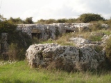
Cleenrah has a single west facing chamber measuring c.2m long and c.2m wide. The sides and back are made up of five stones each of which is c. 1.50m high. Two of these are Portal Stones situated 0.45m apart and form the front of the monument. Normally portal stones are the tallest, but at Cleenrah they are around the same height as the other upright chamber stones. An inward leaning slab forms each side of the chamber and a backstone set between each of these, closes the chamber. The Large capstone coveres the chamber measuring 2.7m long, 2.5m wide and 1.25m thick
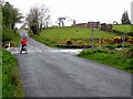
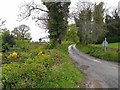
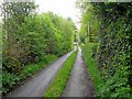
Heading North through Aughnacliffe Village, take the first right (about 1KM after Church. Go left after 500M at a small crossroads. The monument is on the right after about 800M, just after crossing a small stream that flows from Leebeen Lough and is accessed through a gate into the field. There is no parking on this narrow road so park further up at the farmhouse and walk back down the road. Private Property. Ask permission!
You may be viewing yesterday's version of this page. To see the most up to date information please register for a free account.
Do not use the above information on other web sites or publications without permission of the contributor.
davidmorgan has found this location on Google Street View:
Nearby Images from Geograph Britain and Ireland:
©2009(licence)
©2009(licence)
©2009(licence)
©2009(licence)
The above images may not be of the site on this page, they are loaded from Geograph.
Please Submit an Image of this site or go out and take one for us!
Click here to see more info for this site
Nearby sites
Click here to view sites on an interactive map of the areaKey: Red: member's photo, Blue: 3rd party photo, Yellow: other image, Green: no photo - please go there and take one, Grey: site destroyed
Download sites to:
KML (Google Earth)
GPX (GPS waypoints)
CSV (Garmin/Navman)
CSV (Excel)
To unlock full downloads you need to sign up as a Contributory Member. Otherwise downloads are limited to 50 sites.
Turn off the page maps and other distractions
Nearby sites listing. In the following links * = Image available
1.4km SSW 194° Aghnacliff* Portal Tomb (N263884)
12.1km SE 135° Cartronbore Stone Circle
16.2km W 280° Druid's Altar (Clooncoe) Cist
24.3km NW 320° Fenagh Beg* Portal Tomb
25.3km N 357° Crom Cruaich Stone Circle (H250150)
25.6km N 353° Kilnavert A Stone Circle (H235152)
25.6km N 353° Kilnavert B Stone Circle (H235152)
25.6km N 350° Lissanover Stone Circle (H220150)
26.3km N 354° Killycluggin Stone Circle (H239160)
26.7km NE 48° Shantemon Stone Row / Alignment (H4642707815)
26.9km N 5° Aughrim Wedge Tomb (H2879816563)
27.6km ESE 105° Farranaglogh Standing Stones
30.7km NW 305° Drumaleague Lough Crannog* Crannog (H0135007370)
32.8km ESE 113° Carbane West Chambered Cairn (N571773)
32.9km ESE 112° Loughcrew Cairn L* Chambered Cairn (N5719877410)
33.3km ESE 110° Ballinvalley* Stone Circle (N581785)
33.5km NNE 30° Druids Temple (Co.Fermanagh) Stone Circle (H430190)
34.1km ESE 111° Loughcrew Cairn S* Passage Grave (N5857577584)
34.1km ESE 111° Loughcrew Cairn T* Chambered Cairn (N5860477578)
34.1km ESE 111° Loughcrew Cairn U* Passage Grave (N5862977605)
34.2km ESE 111° Loughcrew Cairn V* Passage Grave
34.2km ESE 111° Loughcrew Cairn W* Passage Grave
34.3km NNE 28° Annaghmore Glebe Cairn (H427201)
34.3km NNE 29° Kiltober Stone Circle (H430200)
34.4km ESE 110° Ballinvally ME009-084 Rock Art (N5900377909)
View more nearby sites and additional images


 We would like to know more about this location. Please feel free to add a brief description and any relevant information in your own language.
 Wir möchten mehr über diese Stätte erfahren. Bitte zögern Sie nicht, eine kurze Beschreibung und relevante Informationen in Deutsch hinzuzufügen.
 Nous aimerions en savoir encore un peu sur les lieux. S'il vous plaît n'hesitez pas à ajouter une courte description et tous les renseignements pertinents dans votre propre langue.
 Quisieramos informarnos un poco más de las lugares. No dude en añadir una breve descripción y otros datos relevantes en su propio idioma.