


<< Our Photo Pages >> Baunfree - Passage Grave in Ireland (Republic of) in Co. Kilkenny
Submitted by ainsloch on Saturday, 24 December 2016 Page Views: 2278
Neolithic and Bronze AgeSite Name: BaunfreeCountry: Ireland (Republic of)
NOTE: This site is 1.166 km away from the location you searched for.
County: Co. Kilkenny Type: Passage Grave
Nearest Town: Carrick-On-Suir Nearest Village: Windgap
Latitude: 52.405220N Longitude: 7.368597W
Condition:
| 5 | Perfect |
| 4 | Almost Perfect |
| 3 | Reasonable but with some damage |
| 2 | Ruined but still recognisable as an ancient site |
| 1 | Pretty much destroyed, possibly visible as crop marks |
| 0 | No data. |
| -1 | Completely destroyed |
| 5 | Superb |
| 4 | Good |
| 3 | Ordinary |
| 2 | Not Good |
| 1 | Awful |
| 0 | No data. |
| 5 | Can be driven to, probably with disabled access |
| 4 | Short walk on a footpath |
| 3 | Requiring a bit more of a walk |
| 2 | A long walk |
| 1 | In the middle of nowhere, a nightmare to find |
| 0 | No data. |
| 5 | co-ordinates taken by GPS or official recorded co-ordinates |
| 4 | co-ordinates scaled from a detailed map |
| 3 | co-ordinates scaled from a bad map |
| 2 | co-ordinates of the nearest village |
| 1 | co-ordinates of the nearest town |
| 0 | no data |
Internal Links:
External Links:
")
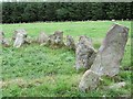
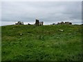
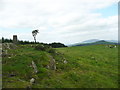
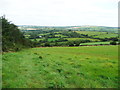
The remains of a passage grave crown the summit of Kilmacoliver Hill. A signposted trail leads from the road which runs alongside the GAA sports pitch, passing through woodland before a fairly steep ascent up the hill through several fields, whereby you shall arrive in a field adjacent to the monument which is on private land. The view from here is said to cover five counties but when we visited unfortunately there was persistent rain and heavy cloud cover.
Knockroe passage mound lies just over 2 miles to the north-west, while a cairn crowns the summit of Slievenamon mountain 8 miles to the west. The remarkable Kilmogue dolmen is located about 4.5 miles due east. All of which indicates that this area was particularly significant in Neolithic times.
You may be viewing yesterday's version of this page. To see the most up to date information please register for a free account.
Do not use the above information on other web sites or publications without permission of the contributor.
Nearby Images from Geograph Britain and Ireland:
©2013(licence)
©2013(licence)
©2014(licence)
©2013(licence)
©2014(licence)
The above images may not be of the site on this page, they are loaded from Geograph.
Please Submit an Image of this site or go out and take one for us!
Click here to see more info for this site
Nearby sites
Click here to view sites on an interactive map of the areaKey: Red: member's photo, Blue: 3rd party photo, Yellow: other image, Green: no photo - please go there and take one, Grey: site destroyed
Download sites to:
KML (Google Earth)
GPX (GPS waypoints)
CSV (Garmin/Navman)
CSV (Excel)
To unlock full downloads you need to sign up as a Contributory Member. Otherwise downloads are limited to 50 sites.
Turn off the page maps and other distractions
Nearby sites listing. In the following links * = Image available
1.9km WNW 295° The Cross of Ages (Kilclispeen)* Ancient Cross (S413291)
3.6km NW 324° Knockroe* Passage Grave (S40863126)
7.1km E 92° Kilmogue standing stone Standing Stone (Menhir)
7.2km E 92° Kilmogue portal tomb* Portal Tomb
9.4km NW 326° Killamery High Cross Ancient Cross (S377361)
10.3km S 191° Ballyquin* Portal Tomb (S411182)
14.3km NNE 28° Kilree Monastery* Ancient Cross
17.5km E 93° Three Friars* Stone Row / Alignment
18.3km NE 49° St Nicholas's Grave (Newtown Jerpoint) Early Christian Sculptured Stone (S56794042)
24.6km SSE 154° Gaulstown Portal Dolmen* Burial Chamber or Dolmen
24.8km SW 229° Tooreen W Stone Row / Alignment (S245117)
26.1km SSE 166° Ballinageeragh* Portal Tomb
26.2km SSE 147° Knockeen Portal Tomb* Portal Tomb (S575065)
26.2km WSW 258° St Patrick's Holy Well (Clonmel) Holy Well or Sacred Spring (S173227)
26.4km SW 230° Carrigeen Standing Stone (Menhir) (S228113)
26.4km SW 231° Knockanaffrin* Standing Stones (S227114)
26.7km SW 231° Kilkeany Stone Circle (S225112)
26.7km E 93° Glencloghlea* Portal Tomb (S698273)
27.0km SW 229° Comeraghglin NE Stone Circle (S227105)
27.1km SW 229° Comeraghglin SW* Stone Circle (S226104)
27.3km SSE 160° Matthewstown* Passage Grave (S528028)
27.7km SSW 194° Drumlohan* Standing Stone (Menhir) (S367013)
28.4km ENE 66° Brandon Hill Stone Circle (S690400)
29.2km ESE 107° Whitechurch Standing Stone Standing Stone (Menhir)
29.4km ESE 109° Whitechurch Stone Circle (S710190)
View more nearby sites and additional images


 We would like to know more about this location. Please feel free to add a brief description and any relevant information in your own language.
 Wir möchten mehr über diese Stätte erfahren. Bitte zögern Sie nicht, eine kurze Beschreibung und relevante Informationen in Deutsch hinzuzufügen.
 Nous aimerions en savoir encore un peu sur les lieux. S'il vous plaît n'hesitez pas à ajouter une courte description et tous les renseignements pertinents dans votre propre langue.
 Quisieramos informarnos un poco más de las lugares. No dude en añadir una breve descripción y otros datos relevantes en su propio idioma.