


<< Text Pages >> Dun Na Killie - Stone Fort or Dun in Scotland in South Uist
Submitted by SolarMegalith on Tuesday, 20 December 2011 Page Views: 2653
Multi-periodSite Name: Dun Na KillieCountry: Scotland
NOTE: This site is 3.943 km away from the location you searched for.
County: South Uist Type: Stone Fort or Dun
Map Ref: NF74611905
Latitude: 57.146604N Longitude: 7.382303W
Condition:
| 5 | Perfect |
| 4 | Almost Perfect |
| 3 | Reasonable but with some damage |
| 2 | Ruined but still recognisable as an ancient site |
| 1 | Pretty much destroyed, possibly visible as crop marks |
| 0 | No data. |
| -1 | Completely destroyed |
| 5 | Superb |
| 4 | Good |
| 3 | Ordinary |
| 2 | Not Good |
| 1 | Awful |
| 0 | No data. |
| 5 | Can be driven to, probably with disabled access |
| 4 | Short walk on a footpath |
| 3 | Requiring a bit more of a walk |
| 2 | A long walk |
| 1 | In the middle of nowhere, a nightmare to find |
| 0 | No data. |
| 5 | co-ordinates taken by GPS or official recorded co-ordinates |
| 4 | co-ordinates scaled from a detailed map |
| 3 | co-ordinates scaled from a bad map |
| 2 | co-ordinates of the nearest village |
| 1 | co-ordinates of the nearest town |
| 0 | no data |
Internal Links:
External Links:
Dun in South Uist
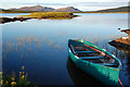
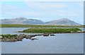
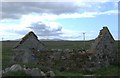
Ruins of a dun located on islet of Loch Dunakillie. Remains of the stone wall and the causeway are still distinguishable. In NE corner of the dun there is a small modern building.
Read More at ScotlandsPlaces.
You may be viewing yesterday's version of this page. To see the most up to date information please register for a free account.
Do not use the above information on other web sites or publications without permission of the contributor.
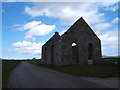
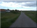
Nearby Images from Geograph Britain and Ireland:
©2007(licence)
©2019(licence)
©2009(licence)
©2009(licence)
©2009(licence)
The above images may not be of the site on this page, they are loaded from Geograph.
Please Submit an Image of this site or go out and take one for us!
Click here to see more info for this site
Nearby sites
Key: Red: member's photo, Blue: 3rd party photo, Yellow: other image, Green: no photo - please go there and take one, Grey: site destroyed
Download sites to:
KML (Google Earth)
GPX (GPS waypoints)
CSV (Garmin/Navman)
CSV (Excel)
To unlock full downloads you need to sign up as a Contributory Member. Otherwise downloads are limited to 50 sites.
Turn off the page maps and other distractions
Nearby sites listing. In the following links * = Image available
359m SW 232° Dun An Duichal Stone Fort or Dun (NF74311885)
1.8km NW 309° Kilpheder Wheelhouse* Ancient Village or Settlement (NF733203)
3.3km NNW 329° Cladh Hallan* Ancient Village or Settlement (NF7313821977)
4.6km S 177° Pollachar* Standing Stone (Menhir) (NF745144)
7.0km N 3° Barp Reineval* Chambered Cairn (NF7549425972)
7.4km ENE 58° Carra Bhroin (Lochboisdale) Standing Stone (Menhir) (NF81172248)
8.2km N 2° Bornais Ancient Village or Settlement (NF7551527184)
8.2km N 354° Dun in Loch na Muilne* Stone Fort or Dun (NF7445327237)
9.7km NNW 344° Ru Ardvule* Stone Row / Alignment (NF72732860)
11.2km NNW 339° Dun Vulan Broch* Broch or Nuraghe (NF71412981)
12.2km SSW 195° Tobar Bharra* Holy Well or Sacred Spring (NF7061607538)
12.2km SSW 196° Kilbar (Isle of Barra)* Ancient Cross (NF703076)
13.3km N 6° An Carra * Standing Stone (Menhir) (NF77033211)
14.6km N 351° Crois Chnoca Breaca* Standing Stone (Menhir) (NF73403366)
17.6km SSW 203° Dun Cuier Broch or Nuraghe (NF6642003406)
18.5km SSW 204° Allasdale Dunes Cairn (NF65610283)
18.6km SSW 199° Dun Bharpa* Chambered Cairn (NF6719001910)
19.1km SSW 197° Balnacraig Cairn Barra * Chambered Cairn (NF67620120)
19.9km SSW 203° Borve Standing Stones* Standing Stones (NF65270144)
20.8km SSW 191° Brevig* Standing Stones (NL689990)
20.8km SSW 198° Tigh Clach Ancient Village or Settlement (NL667997)
21.3km N 358° Drimore, A' Cheardach Bheag* Ancient Village or Settlement (NF757404)
21.6km SSW 202° Tobar Chaluim Chille (Barra)* Holy Well or Sacred Spring (NL6492099654)
22.2km N 358° Drimore, A' Cheardach Mhor* Ancient Village or Settlement (NF75704129)
23.6km SSW 201° Alt Christal, Tangaval Peninsula* Ancient Village or Settlement (NL64259773)
View more nearby sites and additional images


 We would like to know more about this location. Please feel free to add a brief description and any relevant information in your own language.
 Wir möchten mehr über diese Stätte erfahren. Bitte zögern Sie nicht, eine kurze Beschreibung und relevante Informationen in Deutsch hinzuzufügen.
 Nous aimerions en savoir encore un peu sur les lieux. S'il vous plaît n'hesitez pas à ajouter une courte description et tous les renseignements pertinents dans votre propre langue.
 Quisieramos informarnos un poco más de las lugares. No dude en añadir una breve descripción y otros datos relevantes en su propio idioma.