


<< Other Photo Pages >> Tlachtga - Hillfort in Ireland (Republic of) in Co. Meath
Submitted by bat400 on Tuesday, 22 July 2014 Page Views: 3483
Iron Age and Later PrehistorySite Name: Tlachtga Alternative Name: Hill of WardCountry: Ireland (Republic of) County: Co. Meath Type: Hillfort
Nearest Town: Nevan Nearest Village: Athboy
Latitude: 53.625700N Longitude: 6.8884W
Condition:
| 5 | Perfect |
| 4 | Almost Perfect |
| 3 | Reasonable but with some damage |
| 2 | Ruined but still recognisable as an ancient site |
| 1 | Pretty much destroyed, possibly visible as crop marks |
| 0 | No data. |
| -1 | Completely destroyed |
| 5 | Superb |
| 4 | Good |
| 3 | Ordinary |
| 2 | Not Good |
| 1 | Awful |
| 0 | No data. |
| 5 | Can be driven to, probably with disabled access |
| 4 | Short walk on a footpath |
| 3 | Requiring a bit more of a walk |
| 2 | A long walk |
| 1 | In the middle of nowhere, a nightmare to find |
| 0 | No data. |
| 5 | co-ordinates taken by GPS or official recorded co-ordinates |
| 4 | co-ordinates scaled from a detailed map |
| 3 | co-ordinates scaled from a bad map |
| 2 | co-ordinates of the nearest village |
| 1 | co-ordinates of the nearest town |
| 0 | no data |
Internal Links:
External Links:
I have visited· I would like to visit
bishop_pam visited on 23rd Oct 2018 - their rating: Cond: 2 Amb: 4 Access: 5
")
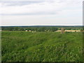
The earthworks seen on the Hill of Ward today represent the last phase of development about 2000 years ago. Barrow burials from earier periods may have been encorporated into the earthworks During medieval times it was the site of great festivals, including one at which winter fires were lit at Samhain.
View some aerial photos on Knowth.com
Note: Dig at 'Halloween ritual site' to get under way.
You may be viewing yesterday's version of this page. To see the most up to date information please register for a free account.
Do not use the above information on other web sites or publications without permission of the contributor.
Nearby Images from Geograph Britain and Ireland:
©2010(licence)
©2010(licence)
©2010(licence)
©2010(licence)
©2011(licence)
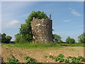
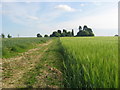
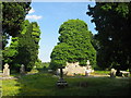
The above images may not be of the site on this page, they are loaded from Geograph.
Please Submit an Image of this site or go out and take one for us!
Click here to see more info for this site
Nearby sites
Click here to view sites on an interactive map of the areaKey: Red: member's photo, Blue: 3rd party photo, Yellow: other image, Green: no photo - please go there and take one, Grey: site destroyed
Download sites to:
KML (Google Earth)
GPX (GPS waypoints)
CSV (Garmin/Navman)
CSV (Excel)
To unlock full downloads you need to sign up as a Contributory Member. Otherwise downloads are limited to 50 sites.
Turn off the page maps and other distractions
Nearby sites listing. In the following links * = Image available
12.8km ENE 75° Donaghmore Stone Circle (N860680)
18.2km NW 326° Kingsmountain Decorated Stone* Rock Art
19.0km ESE 106° Lia Fail* Standing Stone (Menhir) (N9197659625)
19.0km ESE 106° Hill of Tara* Passage Grave (N9201659707)
19.0km ESE 105° Blocc and Bluigne* Standing Stones (N9206359823)
19.1km ESE 107° Tuath Linde* Holy Well or Sacred Spring (N920591)
19.4km NW 314° Cairn X1* Passage Grave (N595779)
19.6km ESE 109° Rath Maeve* Henge
19.7km NW 313° Ballinvally ME009-084 Rock Art (N5900377909)
19.8km NW 312° Loughcrew Cairn W* Passage Grave
19.8km NW 312° Loughcrew Cairn V* Passage Grave
19.8km NW 312° Loughcrew Cairn U* Passage Grave (N5862977605)
19.8km NW 312° Loughcrew Cairn T* Chambered Cairn (N5860477578)
19.8km NW 312° Loughcrew Cairn S* Passage Grave (N5857577584)
20.0km E 99° Lismullin Henge Henge (N93426156)
20.5km E 100° Rath Lugh* Promontory Fort / Cliff Castle (N939613)
20.8km NW 309° Loughcrew Cairn L* Chambered Cairn (N5719877410)
20.8km NW 309° Carbane West Chambered Cairn (N571773)
20.8km NW 313° Ballinvalley* Stone Circle (N581785)
23.9km ESE 119° Moybologue Cemetery Artificial Mound
24.7km ESE 112° Moyer Carns Cairn
24.7km ENE 66° Hill of Slane* Artificial Mound
25.2km NNW 336° Fort Williams Stone Fort or Dun
26.2km NE 54° Grangegeeth Sculptured Stone
27.1km NW 313° Farranaglogh Standing Stones
View more nearby sites and additional images


 We would like to know more about this location. Please feel free to add a brief description and any relevant information in your own language.
 Wir möchten mehr über diese Stätte erfahren. Bitte zögern Sie nicht, eine kurze Beschreibung und relevante Informationen in Deutsch hinzuzufügen.
 Nous aimerions en savoir encore un peu sur les lieux. S'il vous plaît n'hesitez pas à ajouter une courte description et tous les renseignements pertinents dans votre propre langue.
 Quisieramos informarnos un poco más de las lugares. No dude en añadir una breve descripción y otros datos relevantes en su propio idioma.