

<< Our Photo Pages >> Callanish 8A - Standing Stone (Menhir) in Scotland in Isle of Lewis
Submitted by SHUGS on Thursday, 15 February 2001 Page Views: 5649
Neolithic and Bronze AgeSite Name: Callanish 8A Alternative Name: Aird a'Chaolais, Callanish VIIIACountry: Scotland
NOTE: This site is 10.203 km away from the location you searched for.
County: Isle of Lewis Type: Standing Stone (Menhir)
Nearest Town: Stornoway Nearest Village: Callanish
Map Ref: NB165340 Landranger Map Number: 13
Latitude: 58.203312N Longitude: 6.82767W
Condition:
| 5 | Perfect |
| 4 | Almost Perfect |
| 3 | Reasonable but with some damage |
| 2 | Ruined but still recognisable as an ancient site |
| 1 | Pretty much destroyed, possibly visible as crop marks |
| 0 | No data. |
| -1 | Completely destroyed |
| 5 | Superb |
| 4 | Good |
| 3 | Ordinary |
| 2 | Not Good |
| 1 | Awful |
| 0 | No data. |
| 5 | Can be driven to, probably with disabled access |
| 4 | Short walk on a footpath |
| 3 | Requiring a bit more of a walk |
| 2 | A long walk |
| 1 | In the middle of nowhere, a nightmare to find |
| 0 | No data. |
| 5 | co-ordinates taken by GPS or official recorded co-ordinates |
| 4 | co-ordinates scaled from a detailed map |
| 3 | co-ordinates scaled from a bad map |
| 2 | co-ordinates of the nearest village |
| 1 | co-ordinates of the nearest town |
| 0 | no data |
Internal Links:
External Links:
I have visited· I would like to visit
rrmoser would like to visit
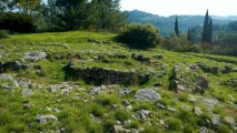
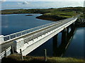
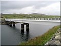
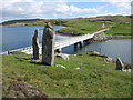
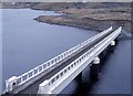
markj99 visited on 3rd Jul 2011 - their rating: Cond: 3 Amb: 4 Access: 4 Callanish VIIIa Standing Stone is accessible via a path up a steep bank on the S End of Bernera Bridge. At least it hasn't been resited in a concrete plinth.
")
"The Stones around Callanish" (ISBN:0-9505998-9-1) tells 'It lies on the verge of an unsignposted minor road, 100m south of the bridge. It seems that it was thrown down during road widening in early '70's'. It was 1.1m tall when erect'. Now it 'stands' on a edge of a cutting to the bridge. Canmore site no. 4116.
You may be viewing yesterday's version of this page. To see the most up to date information please register for a free account.
")
")
")
")
Do not use the above information on other web sites or publications without permission of the contributor.
Nearby Images from Geograph Britain and Ireland:
©2015(licence)
©2007(licence)
©2009(licence)
©2010(licence)
©2014(licence)
The above images may not be of the site on this page, they are loaded from Geograph.
Please Submit an Image of this site or go out and take one for us!
Click here to see more info for this site
Nearby sites
Key: Red: member's photo, Blue: 3rd party photo, Yellow: other image, Green: no photo - please go there and take one, Grey: site destroyed
Download sites to:
KML (Google Earth)
GPX (GPS waypoints)
CSV (Garmin/Navman)
CSV (Excel)
To unlock full downloads you need to sign up as a Contributory Member. Otherwise downloads are limited to 50 sites.
![]()
Turn off the page maps and other distractions
Nearby sites listing. In the following links * = Image available
252m NNW 337° Callanish 8* Stone Circle (NB16423424)
360m NNE 30° Barraglom Cup-Marked Rock Rock Art (NB167343)
441m NNE 33° Dun Barraglom Broch or Nuraghe (NB16773435)
1.3km ENE 63° Callanish 15* Standing Stone (Menhir) (NB177345)
1.8km NW 326° Dun Baravat* Stone Fort or Dun (NB1559835563)
4.8km E 88° Callanish 16* Standing Stone (Menhir) (NB213338)
4.8km ENE 68° Cnoc a Phrionnsa* Chambered Cairn (NB211355)
4.9km E 98° Callanish I* Stone Circle (NB2128633009)
4.9km E 98° Callanish* Stone Circle (NB2129833013)
5.0km E 85° Callanish 13* Standing Stones (NB215341)
5.1km ENE 75° Callanish 12* Standing Stone (Menhir) (NB2155634967)
5.3km ENE 78° Olcote Kerbed Cairn* Cairn (NB2179634733)
5.4km E 96° Callanish 19* Stone Circle (NB218331)
5.8km NNW 327° Carnan Gibegeo Propped Stone CG1* Rock Outcrop (NB13653911)
5.9km NNW 327° Carnan Gibegeo Propped Stone CG2* Rock Outcrop (NB13653913)
5.9km E 100° Callanish 2* Stone Circle (NB2221432614)
5.9km E 101° Loch Roag Timber Circle (NB222325)
5.9km NNW 329° Carnan Gibegeo Propped Stone CG4* Rock Outcrop (NB13843932)
5.9km NNW 329° Carnan Gibegeo Propped Stone CG3* Rock Outcrop (NB13833932)
6.0km ENE 69° Callanish 11* Standing Stone (Menhir) (NB22233569)
6.1km NNW 329° Stiogha Chnap Propped Stone SC1* Rock Outcrop (NB1371539472)
6.1km E 98° Callanish 3* Stone Circle (NB2251532710)
6.1km NNW 329° Stiogha Chnap Propped Stone SC2* Rock Outcrop (NB13703947)
6.2km W 277° Traigh na Berie* Broch or Nuraghe (NB1035235177)
6.4km E 96° Callanish 14* Standing Stone (Menhir) (NB228329)
View more nearby sites and additional images


 We would like to know more about this location. Please feel free to add a brief description and any relevant information in your own language.
 Wir möchten mehr über diese Stätte erfahren. Bitte zögern Sie nicht, eine kurze Beschreibung und relevante Informationen in Deutsch hinzuzufügen.
 Nous aimerions en savoir encore un peu sur les lieux. S'il vous plaît n'hesitez pas à ajouter une courte description et tous les renseignements pertinents dans votre propre langue.
 Quisieramos informarnos un poco más de las lugares. No dude en añadir una breve descripción y otros datos relevantes en su propio idioma.