


<< Our Photo Pages >> Cailleach na Mointeach Kerbed Cairn - Cairn in Scotland in Isle of Lewis
Submitted by Aluta on Thursday, 01 February 2007 Page Views: 18199
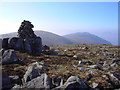
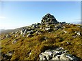
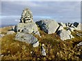
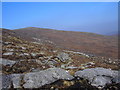
Neolithic and Bronze AgeSite Name: Cailleach na Mointeach Kerbed Cairn Alternative Name: Old Woman of the Moors, Sleeping BeautyCountry: Scotland County: Isle of Lewis Type: Cairn
Nearest Town: Stornoway Nearest Village: Callanish
Map Ref: NB2724414555
Latitude: 58.036009N Longitude: 6.622831W
Condition:
| 5 | Perfect |
| 4 | Almost Perfect |
| 3 | Reasonable but with some damage |
| 2 | Ruined but still recognisable as an ancient site |
| 1 | Pretty much destroyed, possibly visible as crop marks |
| 0 | No data. |
| -1 | Completely destroyed |
| 5 | Superb |
| 4 | Good |
| 3 | Ordinary |
| 2 | Not Good |
| 1 | Awful |
| 0 | No data. |
| 5 | Can be driven to, probably with disabled access |
| 4 | Short walk on a footpath |
| 3 | Requiring a bit more of a walk |
| 2 | A long walk |
| 1 | In the middle of nowhere, a nightmare to find |
| 0 | No data. |
| 5 | co-ordinates taken by GPS or official recorded co-ordinates |
| 4 | co-ordinates scaled from a detailed map |
| 3 | co-ordinates scaled from a bad map |
| 2 | co-ordinates of the nearest village |
| 1 | co-ordinates of the nearest town |
| 0 | no data |
Be the first person to rate this site - see the 'Contribute!' box in the right hand menu.
Internal Links:
External Links:
I have visited· I would like to visit
rrmoser would like to visit
")
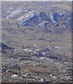
The wind farm would mar the view of the mountains as it has been seen from the stones since they were placed and some say it would defile what they see as a landscape especially sacred to the earth goddess. The current plans will mean seven turbines clearly visible in silhoutte upon the Cailleach and a further 46 dotted around her base."
Should the cairn prove to be ancient, it might be used to prove that the mountains were also sacred to the people who built the Callanish stone circle. Significantly, the prospective builder of the wind farm, Nicholas Oppenheim, has been quoted as saying, "If there is something, it would be fascinating and the scheme would be amended. But I'd like to hear more about what it is."
Ian McHardy adds "The wind farm project is not about to be built just yet- its is however in the critical final planning stages- all the more reason for anyone to help the cause by writing to:
Paul Smith, The Scottish Executive, Consents and Emergency Planning Unit, 2nd Floor, Meridian Court, 5 Cadogan Street, Glasgow G2 6AT, e-mail paul.smith@scotland.gsi.gov.uk
Also have a look at the Moorland without turbines web site (www.mwtlewis.org.uk)."
There is more in the original article from the Scotsman.
Note: Campaign to Save the Sleeping Beauty and Callanish. Megalithic Portal exclusive: Photos from Ian McHardy of his cairn discovery at the 'Sleeping Beauty's knees that could affect the wind farm development. Update: site grid reference + address + web links for the anti-wind-turbines campaign
You may be viewing yesterday's version of this page. To see the most up to date information please register for a free account.
")
")
Do not use the above information on other web sites or publications without permission of the contributor.
Nearby Images from Geograph Britain and Ireland:
©2009(licence)
©2014(licence)
©2009(licence)
©2014(licence)
©2009(licence)
The above images may not be of the site on this page, they are loaded from Geograph.
Please Submit an Image of this site or go out and take one for us!
Click here to see more info for this site
Nearby sites
Key: Red: member's photo, Blue: 3rd party photo, Yellow: other image, Green: no photo - please go there and take one, Grey: site destroyed
Download sites to:
KML (Google Earth)
GPX (GPS waypoints)
CSV (Garmin/Navman)
CSV (Excel)
To unlock full downloads you need to sign up as a Contributory Member. Otherwise downloads are limited to 50 sites.
Turn off the page maps and other distractions
Nearby sites listing. In the following links * = Image available
2.2km NNE 12° Loch Seaforth* Stone Circle (NB2782216637)
4.7km NNE 16° Cnoc nan Clach (Hillock of Stone)* Cairn (NB2886718971)
12.7km ENE 62° Torastay* Cairn (NB38881976)
14.2km ENE 61° Dun Cromore* Stone Fort or Dun (NB4012320699)
14.9km NNW 345° Callanish 18* Standing Stone (Menhir) (NB24402923)
15.3km NNE 13° Achmore* Stone Circle (NB31742926)
15.6km NNW 342° Callanish 9* Standing Stones (NB233297)
15.8km NNW 342° Callanish 5* Stone Row / Alignment (NB23432990)
16.0km NNW 347° Callanish 6* Standing Stones (NB24653034)
16.1km NNW 342° Callanish 7* Ancient Mine, Quarry or other Industry (NB232302)
16.4km NNW 341° Callanish 4* Stone Circle (NB2298830412)
17.8km NNW 345° Callanish 17* Stone Circle (NB237320)
18.1km NNW 341° Cnoc Fillibhir Mhor* Stone Row / Alignment (NB22683207)
18.6km NNW 340° Loch Roag Timber Circle (NB222325)
18.7km NNW 341° Callanish 2* Stone Circle (NB2221432614)
18.7km NNW 342° Callanish 3* Stone Circle (NB2251532710)
18.8km NNW 342° Callanish 14* Standing Stone (Menhir) (NB228329)
19.3km NNW 340° Callanish 19* Stone Circle (NB218331)
19.3km NNE 31° Druim Dubh* Stone Circle (NB382305)
19.3km NNW 338° Callanish I* Stone Circle (NB2128633009)
19.3km NNW 338° Callanish* Stone Circle (NB2129833013)
19.5km NNW 343° Callanish 10* Stone Circle (NB22973362)
20.1km NNW 339° Callanish 16* Standing Stone (Menhir) (NB213338)
20.3km NNW 340° Callanish 13* Standing Stones (NB215341)
20.9km NNW 341° Olcote Kerbed Cairn* Cairn (NB2179634733)
View more nearby sites and additional images


 We would like to know more about this location. Please feel free to add a brief description and any relevant information in your own language.
 Wir möchten mehr über diese Stätte erfahren. Bitte zögern Sie nicht, eine kurze Beschreibung und relevante Informationen in Deutsch hinzuzufügen.
 Nous aimerions en savoir encore un peu sur les lieux. S'il vous plaît n'hesitez pas à ajouter une courte description et tous les renseignements pertinents dans votre propre langue.
 Quisieramos informarnos un poco más de las lugares. No dude en añadir una breve descripción y otros datos relevantes en su propio idioma.