


<< Our Photo Pages >> Serra de Montesinho - Rock Outcrop in Portugal in Bragança
Submitted by Alta-Falisa on Saturday, 01 August 2015 Page Views: 1326
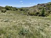
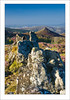
Natural PlacesSite Name: Serra de MontesinhoCountry: Portugal
NOTE: This site is 10.144 km away from the location you searched for.
Distrito: Bragança Type: Rock Outcrop
Nearest Town: Bragança Nearest Village: Montesinho
Latitude: 41.965700N Longitude: 6.7873W
Condition:
| 5 | Perfect |
| 4 | Almost Perfect |
| 3 | Reasonable but with some damage |
| 2 | Ruined but still recognisable as an ancient site |
| 1 | Pretty much destroyed, possibly visible as crop marks |
| 0 | No data. |
| -1 | Completely destroyed |
| 5 | Superb |
| 4 | Good |
| 3 | Ordinary |
| 2 | Not Good |
| 1 | Awful |
| 0 | No data. |
| 5 | Can be driven to, probably with disabled access |
| 4 | Short walk on a footpath |
| 3 | Requiring a bit more of a walk |
| 2 | A long walk |
| 1 | In the middle of nowhere, a nightmare to find |
| 0 | No data. |
| 5 | co-ordinates taken by GPS or official recorded co-ordinates |
| 4 | co-ordinates scaled from a detailed map |
| 3 | co-ordinates scaled from a bad map |
| 2 | co-ordinates of the nearest village |
| 1 | co-ordinates of the nearest town |
| 0 | no data |
Internal Links:
External Links:
")
An eye-catching granitic rock formation.
(I do not guarantee the exact coordinates, but it is definitely at this T-junction, near the border PT-SP).
You may be viewing yesterday's version of this page. To see the most up to date information please register for a free account.
Do not use the above information on other web sites or publications without permission of the contributor.
Nearby Images from Flickr


The above images may not be of the site on this page, but were taken nearby. They are loaded from Flickr so please click on them for image credits.
Click here to see more info for this site
Nearby sites
Click here to view sites on an interactive map of the areaKey: Red: member's photo, Blue: 3rd party photo, Yellow: other image, Green: no photo - please go there and take one, Grey: site destroyed
Download sites to:
KML (Google Earth)
GPX (GPS waypoints)
CSV (Garmin/Navman)
CSV (Excel)
To unlock full downloads you need to sign up as a Contributory Member. Otherwise downloads are limited to 50 sites.
Turn off the page maps and other distractions
Nearby sites listing. In the following links * = Image available
5.7km SE 129° Cidadela Carving
14.0km SE 145° Castro de Sacóias Castro or Chafurdão
14.9km S 186° Mamoa de Donai Burial Chamber or Dolmen
16.8km SSE 157° Castro de Gimonde Castro or Chafurdão
30.9km WNW 290° Estatua-Menhir do Cichón Standing Stone (Menhir)
33.3km S 171° Castro de Ciragata Castro or Chafurdão
35.7km NW 312° Castro do Castelo Castro or Chafurdão
39.6km NNW 327° Castro de Santa Cristina Castro or Chafurdão
44.3km SW 219° Torre de Dona Chama Castro or Chafurdão
46.8km SE 129° Pena del Moro Castro or Chafurdão
48.6km WSW 245° Pedra Bolideira* Natural Stone / Erratic / Other Natural Feature
50.6km SW 217° Castro de São Juzenda Castro or Chafurdão
52.5km S 174° Castro de Vale de Águia Castro or Chafurdão
52.6km S 174° Castro de Aldeia Nova Castro or Chafurdão
54.4km WSW 239° Castro da Lama de Ouriço Castro or Chafurdão
54.7km NNW 332° Castro da Coroa (Ruá) Castro or Chafurdão
55.1km N 2° Las Médulas* Ancient Mine, Quarry or other Industry
55.9km SW 233° Castro de Vilarandelo Castro or Chafurdão
56.3km W 274° Petróglifo das Covas Rubias Rock Art
58.2km N 4° Castro Borrenes* Castro or Chafurdão
58.6km W 265° Petróglifos das Chás Rock Art
60.9km WNW 283° Pedrafita de Rebordiño Standing Stone (Menhir)
62.0km N 3° Castrolin de San Juan de Paluezas* Castro or Chafurdão
62.0km WSW 246° Museo da Região Flaviense* Museum
62.9km SW 235° Castro de Vilanova Castro or Chafurdão
View more nearby sites and additional images


 We would like to know more about this location. Please feel free to add a brief description and any relevant information in your own language.
 Wir möchten mehr über diese Stätte erfahren. Bitte zögern Sie nicht, eine kurze Beschreibung und relevante Informationen in Deutsch hinzuzufügen.
 Nous aimerions en savoir encore un peu sur les lieux. S'il vous plaît n'hesitez pas à ajouter une courte description et tous les renseignements pertinents dans votre propre langue.
 Quisieramos informarnos un poco más de las lugares. No dude en añadir una breve descripción y otros datos relevantes en su propio idioma.