


<< Our Photo Pages >> Castrolin de San Juan de Paluezas - Castro or Chafurdão in Spain in Castilla y León
Submitted by Armand on Monday, 18 September 2017 Page Views: 1505
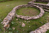
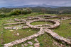
Iron Age and Later PrehistorySite Name: Castrolin de San Juan de PaluezasCountry: Spain Region: Castilla y León Type: Castro or Chafurdão
Nearest Town: Ponferrada Nearest Village: San Juan de Paluezas
Latitude: 42.522535N Longitude: 6.753695W
Condition:
| 5 | Perfect |
| 4 | Almost Perfect |
| 3 | Reasonable but with some damage |
| 2 | Ruined but still recognisable as an ancient site |
| 1 | Pretty much destroyed, possibly visible as crop marks |
| 0 | No data. |
| -1 | Completely destroyed |
| 5 | Superb |
| 4 | Good |
| 3 | Ordinary |
| 2 | Not Good |
| 1 | Awful |
| 0 | No data. |
| 5 | Can be driven to, probably with disabled access |
| 4 | Short walk on a footpath |
| 3 | Requiring a bit more of a walk |
| 2 | A long walk |
| 1 | In the middle of nowhere, a nightmare to find |
| 0 | No data. |
| 5 | co-ordinates taken by GPS or official recorded co-ordinates |
| 4 | co-ordinates scaled from a detailed map |
| 3 | co-ordinates scaled from a bad map |
| 2 | co-ordinates of the nearest village |
| 1 | co-ordinates of the nearest town |
| 0 | no data |
Internal Links:
External Links:
")
For more information see Las Medulas, which includes information about El Castrelín de San Juan de Paluezas.
Note: Has anyone visited this site? Do you have any information or comments to add?
You may be viewing yesterday's version of this page. To see the most up to date information please register for a free account.
")
")
Do not use the above information on other web sites or publications without permission of the contributor.
Nearby Images from Flickr
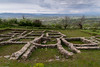
The above images may not be of the site on this page, but were taken nearby. They are loaded from Flickr so please click on them for image credits.
Click here to see more info for this site
Nearby sites
Click here to view sites on an interactive map of the areaKey: Red: member's photo, Blue: 3rd party photo, Yellow: other image, Green: no photo - please go there and take one, Grey: site destroyed
Download sites to:
KML (Google Earth)
GPX (GPS waypoints)
CSV (Garmin/Navman)
CSV (Excel)
To unlock full downloads you need to sign up as a Contributory Member. Otherwise downloads are limited to 50 sites.
Turn off the page maps and other distractions
Nearby sites listing. In the following links * = Image available
4.2km SSE 157° Castro Borrenes* Castro or Chafurdão
7.0km S 190° Las Médulas* Ancient Mine, Quarry or other Industry
8.0km N 356° Castro Ventosa Castro or Chafurdão
29.3km WNW 302° Castro de Cerracín Castro or Chafurdão
31.5km WSW 244° Castro da Coroa (Ruá) Castro or Chafurdão
32.6km WNW 292° Castro de Monte Cido Castro or Chafurdão
32.7km WNW 299° Castro da Escrita ou Tralocastro Castro or Chafurdão
32.9km WNW 292° Necrópolis Pena do Cuco Barrow Cemetery
33.5km NNW 332° Castro Río de Cereixedo Castro or Chafurdão
34.0km WNW 293° Castro da Devesa do Rei Castro or Chafurdão
34.7km WNW 293° Castro de Piñeira Castro or Chafurdão
35.0km WNW 298° Castro de Vilela (Folgoso) Castro or Chafurdão
35.5km WNW 293° Castro de Santo Estevo Castro or Chafurdão
35.9km WNW 286° Castro de A Torre Castro or Chafurdão
36.5km WNW 295° Castro de Meiraos Castro or Chafurdão
36.9km WNW 287° Castro da Torre* Castro or Chafurdão
37.0km WNW 293° Castro de Brigo Castro or Chafurdão
37.1km WNW 282° Castro de Torexe Castro or Chafurdão
37.4km SW 220° Castro de Santa Cristina Castro or Chafurdão
37.5km WNW 295° Castro de Miraz* Castro or Chafurdão
38.9km W 265° Castro de Barreiro Castro or Chafurdão
39.7km W 276° Castro de Vilar* Castro or Chafurdão
39.9km W 279° Castro de Vilamor Castro or Chafurdão
41.2km NW 311° Castro da Coroa (Sinllán) Castro or Chafurdão
41.8km NW 323° Castro de Pena Tallada Castro or Chafurdão
View more nearby sites and additional images


 We would like to know more about this location. Please feel free to add a brief description and any relevant information in your own language.
 Wir möchten mehr über diese Stätte erfahren. Bitte zögern Sie nicht, eine kurze Beschreibung und relevante Informationen in Deutsch hinzuzufügen.
 Nous aimerions en savoir encore un peu sur les lieux. S'il vous plaît n'hesitez pas à ajouter une courte description et tous les renseignements pertinents dans votre propre langue.
 Quisieramos informarnos un poco más de las lugares. No dude en añadir una breve descripción y otros datos relevantes en su propio idioma.