


<< Our Photo Pages >> Dun Neill - Stone Fort or Dun in Scotland in Isle of Skye
Submitted by Andy B on Tuesday, 13 April 2010 Page Views: 4398
Multi-periodSite Name: Dun NeillCountry: Scotland
NOTE: This site is 1.11 km away from the location you searched for.
County: Isle of Skye Type: Stone Fort or Dun
Map Ref: NG28114073
Latitude: 57.375535N Longitude: 6.524836W
Condition:
| 5 | Perfect |
| 4 | Almost Perfect |
| 3 | Reasonable but with some damage |
| 2 | Ruined but still recognisable as an ancient site |
| 1 | Pretty much destroyed, possibly visible as crop marks |
| 0 | No data. |
| -1 | Completely destroyed |
| 5 | Superb |
| 4 | Good |
| 3 | Ordinary |
| 2 | Not Good |
| 1 | Awful |
| 0 | No data. |
| 5 | Can be driven to, probably with disabled access |
| 4 | Short walk on a footpath |
| 3 | Requiring a bit more of a walk |
| 2 | A long walk |
| 1 | In the middle of nowhere, a nightmare to find |
| 0 | No data. |
| 5 | co-ordinates taken by GPS or official recorded co-ordinates |
| 4 | co-ordinates scaled from a detailed map |
| 3 | co-ordinates scaled from a bad map |
| 2 | co-ordinates of the nearest village |
| 1 | co-ordinates of the nearest town |
| 0 | no data |
Internal Links:
External Links:
I have visited· I would like to visit
Andy B has visited here
")
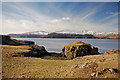
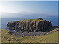
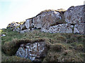
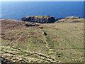
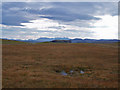
The remains of the dun are on the summit of the flat-topped rock in the centre. It almost becomes an island at high tides, but is seen here near to low tide. There are only a couple of courses of stonework remaining on the top.
You may be viewing yesterday's version of this page. To see the most up to date information please register for a free account.
")
")
Do not use the above information on other web sites or publications without permission of the contributor.
Nearby Images from Geograph Britain and Ireland:
©2010(licence)
©2009(licence)
©2009(licence)
©2009(licence)
©2010(licence)
The above images may not be of the site on this page, they are loaded from Geograph.
Please Submit an Image of this site or go out and take one for us!
Click here to see more info for this site
Nearby sites
Key: Red: member's photo, Blue: 3rd party photo, Yellow: other image, Green: no photo - please go there and take one, Grey: site destroyed
Download sites to:
KML (Google Earth)
GPX (GPS waypoints)
CSV (Garmin/Navman)
CSV (Excel)
To unlock full downloads you need to sign up as a Contributory Member. Otherwise downloads are limited to 50 sites.
Turn off the page maps and other distractions
Nearby sites listing. In the following links * = Image available
2.4km NE 45° Dun Feorlig* Broch or Nuraghe (NG299423)
3.3km NE 54° Dun Abhuinn Bhaile Mheadhonaich* Stone Fort or Dun (NG309425)
3.7km NNE 24° Vatten* Cairn (NG2983843987)
4.6km NW 325° Dun Cnoc a'Sga* Stone Fort or Dun (NG257447)
5.1km ESE 121° Ullinish Lodge* Chambered Cairn (NG323378)
5.7km ESE 109° Ullinish Souterrain Souterrain (Fogou, Earth House) (NG334385)
6.1km ESE 103° Dun Mor (Struan)* Stone Fort or Dun (NG340390)
6.2km ESE 106° Dun Beag (Struan)* Broch or Nuraghe (NG3395438630)
6.4km ESE 115° Struanmore* Chambered Cairn (NG337376)
6.9km NW 321° Dun Osdale Broch* Broch or Nuraghe (NG24124641)
6.9km WNW 298° Healabhal Mhor chambered cairn* Chambered Cairn (NG222444)
7.1km ENE 71° Dun Arkaig* Broch or Nuraghe (NG350426)
7.3km SE 129° Dun Ardtreck* Broch or Nuraghe (NG335358)
7.7km ESE 106° Dun Diarmaid* Broch or Nuraghe (NG35453816)
8.2km E 100° Dun Garsin* Broch or Nuraghe (NG361388)
8.4km SSE 161° Cave of the Speckled Horses Cave or Rock Shelter (NG30283264)
8.4km NW 325° Dun Totaig* Stone Fort or Dun (NG237479)
8.9km SE 131° Crois Mic Jamain Standing Stones (NG345345)
9.0km NNW 334° Dun Osdale Pictish Symbol Stone* Class I Pictish Symbol Stone (NG24734911)
9.1km ESE 113° Dun Taimh* Stone Fort or Dun (NG363366)
10.8km NNW 329° Dun Fiadhairt* Broch or Nuraghe (NG232504)
12.0km N 352° Temple of Anaitis (Waternish) Stone Circle (NG27255273)
12.2km SSE 156° Dun Sleadale* Broch or Nuraghe (NG323292)
12.3km E 89° Tungadal* Souterrain (Fogou, Earth House) (NG404401)
12.5km NNE 32° Dun Edinbane* Broch or Nuraghe (NG35355092)
View more nearby sites and additional images


 We would like to know more about this location. Please feel free to add a brief description and any relevant information in your own language.
 Wir möchten mehr über diese Stätte erfahren. Bitte zögern Sie nicht, eine kurze Beschreibung und relevante Informationen in Deutsch hinzuzufügen.
 Nous aimerions en savoir encore un peu sur les lieux. S'il vous plaît n'hesitez pas à ajouter une courte description et tous les renseignements pertinents dans votre propre langue.
 Quisieramos informarnos un poco más de las lugares. No dude en añadir una breve descripción y otros datos relevantes en su propio idioma.