


<< Text Pages >> Dun Cruit - Stone Fort or Dun in Scotland in Argyll
Submitted by coin on Tuesday, 28 April 2015 Page Views: 1619
Multi-periodSite Name: Dun Cruit Alternative Name: Dùn CruitCountry: Scotland
NOTE: This site is 5.686 km away from the location you searched for.
County: Argyll Type: Stone Fort or Dun
Nearest Town: Oban Nearest Village: Iona
Map Ref: NM27634206
Latitude: 56.491574N Longitude: 6.426659W
Condition:
| 5 | Perfect |
| 4 | Almost Perfect |
| 3 | Reasonable but with some damage |
| 2 | Ruined but still recognisable as an ancient site |
| 1 | Pretty much destroyed, possibly visible as crop marks |
| 0 | No data. |
| -1 | Completely destroyed |
| 5 | Superb |
| 4 | Good |
| 3 | Ordinary |
| 2 | Not Good |
| 1 | Awful |
| 0 | No data. |
| 5 | Can be driven to, probably with disabled access |
| 4 | Short walk on a footpath |
| 3 | Requiring a bit more of a walk |
| 2 | A long walk |
| 1 | In the middle of nowhere, a nightmare to find |
| 0 | No data. |
| 5 | co-ordinates taken by GPS or official recorded co-ordinates |
| 4 | co-ordinates scaled from a detailed map |
| 3 | co-ordinates scaled from a bad map |
| 2 | co-ordinates of the nearest village |
| 1 | co-ordinates of the nearest town |
| 0 | no data |
Internal Links:
External Links:
I have visited· I would like to visit
coin couldn't find
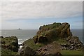
According to the record, the dun consists of a 'distinctly traceable' wall, on an inaccessible rock stack, which would have been connected to Lunga main via a drawbridge.
The island can be accessed on boat trips to Lunga, Staffa and Iona.
Source: RACHMS (1980)
You may be viewing yesterday's version of this page. To see the most up to date information please register for a free account.
Do not use the above information on other web sites or publications without permission of the contributor.
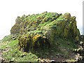
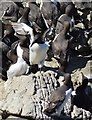
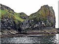
Nearby Images from Geograph Britain and Ireland:
©2014(licence)
©2011(licence)

©2018(licence)
©2018(licence)
©2011(licence)
The above images may not be of the site on this page, they are loaded from Geograph.
Please Submit an Image of this site or go out and take one for us!
Click here to see more info for this site
Nearby sites
Key: Red: member's photo, Blue: 3rd party photo, Yellow: other image, Green: no photo - please go there and take one, Grey: site destroyed
Download sites to:
KML (Google Earth)
GPX (GPS waypoints)
CSV (Garmin/Navman)
CSV (Excel)
To unlock full downloads you need to sign up as a Contributory Member. Otherwise downloads are limited to 50 sites.
Turn off the page maps and other distractions
Nearby sites listing. In the following links * = Image available
7.9km NE 43° Dun Haunn Stone Fort or Dun (NM33434749)
9.5km E 98° Tigh An Duine Stone Fort or Dun (NM36944013)
10.6km ENE 69° Dun Aisgain Stone Fort or Dun (NM37744524)
11.1km NE 44° Creag A' Chaisteal Rock Art (NM35874957)
11.5km ENE 70° Dun Ban, Tostarie Stone Fort or Dun (NM38694524)
12.0km ENE 69° Tostarie* Standing Stone (Menhir) (NM3918145614)
12.2km ENE 70° Torr Damh* Cairn (NM39434544)
12.6km ENE 69° Tobar Ninian* Holy Well or Sacred Spring (NM3976545784)
13.0km E 100° Cragaig* Standing Stones (NM40283901)
13.1km NE 40° Calgary Pier Stone Fort or Dun (NM36705151)
14.1km NE 34° Lag Standing Stones* Standing Stones (NM3626753307)
14.5km NNE 30° Port Na Caillich Stone Fort or Dun (NM35785408)
14.5km NNW 334° Fiskary Bay Mesolithic Settlement Ancient Village or Settlement (NM221555)
14.5km NE 36° Allt Cill Chriosd Stone Fort or Dun (NM36885328)
14.9km NE 43° Calgary* Stone Row / Alignment (NM38495231)
15.1km E 97° Ulva Standing Stone Standing Stone (Menhir) (NM42563926)
15.2km NE 38° Cillchriosd Rock Art (NM37665347)
15.2km NE 38° Cillchriosd* Standing Stone (Menhir) (NM3772553502)
15.6km NE 44° Dun Mhadaidh* Stone Fort or Dun (NM39145260)
15.7km E 82° Dun nan Gall* Broch or Nuraghe (NM43344331)
16.4km E 83° Dun Choinichean Stone Fort or Dun (NM44094312)
16.5km NE 49° Dun Auladh Round Cairn (NM40815212)
16.7km NW 308° Traigh Chrossapol Standing Stone (Menhir) (NM1518853301)
16.8km S 177° Tobar na Gaoithe Tuath (Iona) Holy Well or Sacred Spring (NM275252)
16.8km S 174° Tobar nah Aois* Holy Well or Sacred Spring (NM283252)
View more nearby sites and additional images


 We would like to know more about this location. Please feel free to add a brief description and any relevant information in your own language.
 Wir möchten mehr über diese Stätte erfahren. Bitte zögern Sie nicht, eine kurze Beschreibung und relevante Informationen in Deutsch hinzuzufügen.
 Nous aimerions en savoir encore un peu sur les lieux. S'il vous plaît n'hesitez pas à ajouter une courte description et tous les renseignements pertinents dans votre propre langue.
 Quisieramos informarnos un poco más de las lugares. No dude en añadir una breve descripción y otros datos relevantes en su propio idioma.