


<< Text Pages >> El Cercu los Moros - Castro or Chafurdão in Spain in Asturias
Submitted by johnstone on Wednesday, 12 February 2020 Page Views: 350
Iron Age and Later PrehistorySite Name: El Cercu los MorosCountry: Spain
NOTE: This site is 1.939 km away from the location you searched for.
Region: Asturias Type: Castro or Chafurdão
Nearest Town: Lluarca Nearest Village: Valdés
Latitude: 43.468990N Longitude: 6.48166W
Condition:
| 5 | Perfect |
| 4 | Almost Perfect |
| 3 | Reasonable but with some damage |
| 2 | Ruined but still recognisable as an ancient site |
| 1 | Pretty much destroyed, possibly visible as crop marks |
| 0 | No data. |
| -1 | Completely destroyed |
| 5 | Superb |
| 4 | Good |
| 3 | Ordinary |
| 2 | Not Good |
| 1 | Awful |
| 0 | No data. |
| 5 | Can be driven to, probably with disabled access |
| 4 | Short walk on a footpath |
| 3 | Requiring a bit more of a walk |
| 2 | A long walk |
| 1 | In the middle of nowhere, a nightmare to find |
| 0 | No data. |
| 5 | co-ordinates taken by GPS or official recorded co-ordinates |
| 4 | co-ordinates scaled from a detailed map |
| 3 | co-ordinates scaled from a bad map |
| 2 | co-ordinates of the nearest village |
| 1 | co-ordinates of the nearest town |
| 0 | no data |
Be the first person to rate this site - see the 'Contribute!' box in the right hand menu.
Internal Links:
External Links:
Castro in Asturias
You may be viewing yesterday's version of this page. To see the most up to date information please register for a free account.
Do not use the above information on other web sites or publications without permission of the contributor.
Nearby Images from Flickr
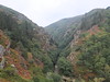
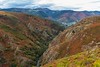

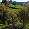


The above images may not be of the site on this page, but were taken nearby. They are loaded from Flickr so please click on them for image credits.
Click here to see more info for this site
Nearby sites
Click here to view sites on an interactive map of the areaKey: Red: member's photo, Blue: 3rd party photo, Yellow: other image, Green: no photo - please go there and take one, Grey: site destroyed
Download sites to:
KML (Google Earth)
GPX (GPS waypoints)
CSV (Garmin/Navman)
CSV (Excel)
To unlock full downloads you need to sign up as a Contributory Member. Otherwise downloads are limited to 50 sites.
Turn off the page maps and other distractions
Nearby sites listing. In the following links * = Image available
6.0km S 178° El Castiellu (Veneiru) Castro or Chafurdão
7.0km NNE 29° La Porida Castro or Chafurdão
7.3km SSW 198° El Castiellu (Veiga) Castro or Chafurdão
8.4km NNE 16° La Cogolla (Caneiru) Castro or Chafurdão
9.8km SSE 165° El Castru (Villatresmil) Castro or Chafurdão
10.0km WNW 292° El Castiellu (Zreizal) Castro or Chafurdão
10.4km NNW 332° Pena Castiel Castro or Chafurdão
11.2km S 190° El Castiellu (lluciernas) Castro or Chafurdão
12.9km NW 316° El Castiellu (La Calea) Castro or Chafurdão
15.0km SSW 193° Túmulos de Campiello Round Barrow(s)
17.4km S 172° El Castrón Castro or Chafurdão
17.5km SSE 156° El Castru (Truébanu) Castro or Chafurdão
18.6km S 180° El Castru (El Peligru) Castro or Chafurdão
18.9km S 187° El Picu los Moros Castro or Chafurdão
19.1km S 182° El Picu San Roque Castro or Chafurdão
19.3km S 169° Fumulín Castro or Chafurdão
19.7km S 172° Castro de Doña Palla* Castro or Chafurdão
21.2km E 97° Las Cogollas Castro or Chafurdão
22.0km WNW 284° Estela Discoidea de Coaña* Standing Stone (Menhir)
22.1km WNW 282° Castro de Coaña* Castro or Chafurdão
23.2km WNW 293° Castro de Mohías* Castro or Chafurdão
23.8km W 260° Castro de Pendia* Castro or Chafurdão
24.2km S 186° El Castiellu los Moros Castro or Chafurdão
24.7km SSE 154° Dolmen de Merilles* Burial Chamber or Dolmen
25.4km SSE 147° Penaguda Castro or Chafurdão
View more nearby sites and additional images


 We would like to know more about this location. Please feel free to add a brief description and any relevant information in your own language.
 Wir möchten mehr über diese Stätte erfahren. Bitte zögern Sie nicht, eine kurze Beschreibung und relevante Informationen in Deutsch hinzuzufügen.
 Nous aimerions en savoir encore un peu sur les lieux. S'il vous plaît n'hesitez pas à ajouter une courte description et tous les renseignements pertinents dans votre propre langue.
 Quisieramos informarnos un poco más de las lugares. No dude en añadir una breve descripción y otros datos relevantes en su propio idioma.