


<< Our Photo Pages >> Benside Newmarket - Stone Circle in Scotland in Isle of Lewis
Submitted by PerkyPuffin on Thursday, 20 October 2022 Page Views: 8408
Neolithic and Bronze AgeSite Name: Benside NewmarketCountry: Scotland
NOTE: This site is 1.153 km away from the location you searched for.
County: Isle of Lewis Type: Stone Circle
Nearest Village: Newmarket
Map Ref: NB4129735652 Landranger Map Number: 8
Latitude: 58.233346N Longitude: 6.408894W
Condition:
| 5 | Perfect |
| 4 | Almost Perfect |
| 3 | Reasonable but with some damage |
| 2 | Ruined but still recognisable as an ancient site |
| 1 | Pretty much destroyed, possibly visible as crop marks |
| 0 | No data. |
| -1 | Completely destroyed |
| 5 | Superb |
| 4 | Good |
| 3 | Ordinary |
| 2 | Not Good |
| 1 | Awful |
| 0 | No data. |
| 5 | Can be driven to, probably with disabled access |
| 4 | Short walk on a footpath |
| 3 | Requiring a bit more of a walk |
| 2 | A long walk |
| 1 | In the middle of nowhere, a nightmare to find |
| 0 | No data. |
| 5 | co-ordinates taken by GPS or official recorded co-ordinates |
| 4 | co-ordinates scaled from a detailed map |
| 3 | co-ordinates scaled from a bad map |
| 2 | co-ordinates of the nearest village |
| 1 | co-ordinates of the nearest town |
| 0 | no data |
Internal Links:
External Links:
I have visited· I would like to visit
tom_bullock has visited here
")
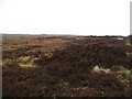
Suggested alignment from PP: Assumed positioned with a pointing stone due North from the middle for sky or lunar observations. An inland site in a bowl valley but mainland Scottish coast can be seen to the South east across the Minches.
Easy to see from a minor road with a parking space opposite . Can be viewed without getting out of the car!
Canmore site no. 4303.
Page originally by Tom Bullock
You may be viewing yesterday's version of this page. To see the most up to date information please register for a free account.
")
")
")
Do not use the above information on other web sites or publications without permission of the contributor.
Nearby Images from Geograph Britain and Ireland:
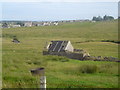
©2006(licence)
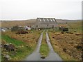
©2009(licence)
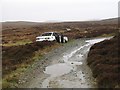
©2009(licence)
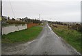
©2009(licence)
©2009(licence)
The above images may not be of the site on this page, they are loaded from Geograph.
Please Submit an Image of this site or go out and take one for us!
Click here to see more info for this site
Nearby sites
Key: Red: member's photo, Blue: 3rd party photo, Yellow: other image, Green: no photo - please go there and take one, Grey: site destroyed
Download sites to:
KML (Google Earth)
GPX (GPS waypoints)
CSV (Garmin/Navman)
CSV (Excel)
To unlock full downloads you need to sign up as a Contributory Member. Otherwise downloads are limited to 50 sites.
Turn off the page maps and other distractions
Nearby sites listing. In the following links * = Image available
529m SSW 198° Priest's Glen* Stone Circle (NB41103516)
2.1km SW 218° Loch Airidh Na Lic* Crannog (NB39923410)
6.0km SSW 207° Druim Dubh* Stone Circle (NB382305)
10.1km NNE 32° Carn A' Mharc Chambered Cairn (NB4722543846)
11.3km E 99° Cnoc Nan Dursainean* Cairn (NB52383307)
11.4km NE 42° Dun Beinn Ivor Stone Fort or Dun (NB495436)
11.4km ESE 120° Teampull* Misc. Earthwork (NB50782924)
11.5km SW 232° Achmore* Stone Circle (NB31742926)
11.6km ESE 113° Loch an Duin (Eye Peninsula)* Stone Fort or Dun (NB51683043)
11.7km E 97° Garrabost* Standing Stone (Menhir) (NB52813340)
13.3km NE 48° Dun Beinn Earba Stone Fort or Dun (NB518438)
15.0km S 181° Dun Cromore* Stone Fort or Dun (NB4012320699)
16.0km S 185° Torastay* Cairn (NB38881976)
16.9km NNW 328° Barabhas* Modern Stone Circle etc (NB333506)
17.2km NW 309° Loch an Duna* Broch or Nuraghe (NB285473)
17.4km WSW 249° Callanish 6* Standing Stones (NB24653034)
17.9km WSW 254° Callanish 17* Stone Circle (NB237320)
18.0km WSW 245° Callanish 18* Standing Stone (Menhir) (NB24402923)
18.4km W 260° Callanish 10* Stone Circle (NB22973362)
18.5km NNW 345° Clach An Truishal* Standing Stone (Menhir) (NB3756053775)
18.5km N 351° Steinacleit* Chambered Tomb (NB39635408)
18.6km WSW 258° Callanish 14* Standing Stone (Menhir) (NB228329)
18.7km WSW 248° Callanish 5* Stone Row / Alignment (NB23432990)
18.8km N 350° Loch an Dùin (Shader)* Broch or Nuraghe (NB39295435)
18.8km WSW 249° Callanish 7* Ancient Mine, Quarry or other Industry (NB232302)
View more nearby sites and additional images


 We would like to know more about this location. Please feel free to add a brief description and any relevant information in your own language.
 Wir möchten mehr über diese Stätte erfahren. Bitte zögern Sie nicht, eine kurze Beschreibung und relevante Informationen in Deutsch hinzuzufügen.
 Nous aimerions en savoir encore un peu sur les lieux. S'il vous plaît n'hesitez pas à ajouter une courte description et tous les renseignements pertinents dans votre propre langue.
 Quisieramos informarnos un poco más de las lugares. No dude en añadir una breve descripción y otros datos relevantes en su propio idioma.