


<< Our Photo Pages >> Millmount - Artificial Mound in Ireland (Republic of) in Co. Louth
Submitted by ainsloch on Sunday, 24 May 2015 Page Views: 1956
Multi-periodSite Name: MillmountCountry: Ireland (Republic of)
NOTE: This site is 1.399 km away from the location you searched for.
County: Co. Louth Type: Artificial Mound
Nearest Town: Drogheda
Latitude: 53.711630N Longitude: 6.349415W
Condition:
| 5 | Perfect |
| 4 | Almost Perfect |
| 3 | Reasonable but with some damage |
| 2 | Ruined but still recognisable as an ancient site |
| 1 | Pretty much destroyed, possibly visible as crop marks |
| 0 | No data. |
| -1 | Completely destroyed |
| 5 | Superb |
| 4 | Good |
| 3 | Ordinary |
| 2 | Not Good |
| 1 | Awful |
| 0 | No data. |
| 5 | Can be driven to, probably with disabled access |
| 4 | Short walk on a footpath |
| 3 | Requiring a bit more of a walk |
| 2 | A long walk |
| 1 | In the middle of nowhere, a nightmare to find |
| 0 | No data. |
| 5 | co-ordinates taken by GPS or official recorded co-ordinates |
| 4 | co-ordinates scaled from a detailed map |
| 3 | co-ordinates scaled from a bad map |
| 2 | co-ordinates of the nearest village |
| 1 | co-ordinates of the nearest town |
| 0 | no data |
Internal Links:
External Links:
I have visited· I would like to visit
mark_a has visited here
")
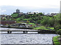
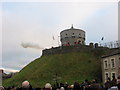
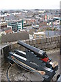
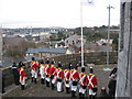
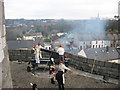
The Millmount Mound is a 200 feet wide, 50 feet high artificial hill which is located in the cultural quarter of Drogheda, where it dominates the surrounding area. It is positioned just south of the River Boyne, and about four miles to the east of Dowth passage mound. The mound has a very colourful history. It is thought that it may originally have been a large passage mound, similar to the better known Boyne Valley trio of Dowth, Newgrange and Knowth. The Normans fortified the mound in the 12th Century when they built a motte and bailey, and later a castle was built at the site. The Martello tower atop the mound suffered damage from shelling during the Irish Civil War, and was restored in 2000. There is now a military museum at the site. The mound is the traditional burial place of Amergin, a famous Celtic warrior poet.
You may be viewing yesterday's version of this page. To see the most up to date information please register for a free account.
Do not use the above information on other web sites or publications without permission of the contributor.
Nearby Images from Geograph Britain and Ireland:
©2015(licence)
©2008(licence)
©2008(licence)
©2008(licence)
©2008(licence)
The above images may not be of the site on this page, they are loaded from Geograph.
Please Submit an Image of this site or go out and take one for us!
Click here to see more info for this site
Nearby sites
Click here to view sites on an interactive map of the areaKey: Red: member's photo, Blue: 3rd party photo, Yellow: other image, Green: no photo - please go there and take one, Grey: site destroyed
Download sites to:
KML (Google Earth)
GPX (GPS waypoints)
CSV (Garmin/Navman)
CSV (Excel)
To unlock full downloads you need to sign up as a Contributory Member. Otherwise downloads are limited to 50 sites.
Turn off the page maps and other distractions
Nearby sites listing. In the following links * = Image available
3.5km WNW 283° Oldbridge Logboat, River Boyne Not Known (by us)
5.6km W 265° Dowth Henge* Henge (O034742)
5.8km W 259° Donore Mystery Mound Artificial Mound (O0334573550)
6.0km W 263° Dowth Hall* Passage Grave
6.4km ENE 60° Baltray* Standing Stones
6.7km W 263° Dowth Passage Grave* Passage Grave (O02377377)
6.9km W 279° Townleyhall Passage Tomb* Passage Grave (O0222075723)
7.7km WSW 254° Newgrange Standing Stones* Standing Stones
8.5km WSW 257° Newgrange* Passage Grave (O00747272)
8.5km NNW 329° Muiredach's Cross (Monasterboice)* Ancient Cross (O044820)
8.6km WSW 257° Newgrange Stone Circle* Stone Circle (O007727)
9.0km WSW 253° Recently Discovered Prehistoric Cropmark near Newgrange* Misc. Earthwork
9.4km W 263° Knowth Timber Circle* Timber Circle (N997734)
9.4km W 263° Knowth* Passage Grave (N99697342)
11.3km S 171° Greenanstown Stone Circle (O110637)
11.8km S 175° Micknanstown* Passage Grave
12.2km NW 317° Tinure* Rock Art (O005835)
12.2km SE 134° Knocknagin* Passage Grave
12.9km S 173° Fourknocks* Passage Grave (O10856202)
12.9km W 273° Hill of Slane* Artificial Mound
13.8km SE 131° Bremore Port* Passage Grave
15.3km WNW 292° Grangegeeth Sculptured Stone
18.6km SSW 204° Kilbrew Henge
19.4km NW 312° Hurlstone* Holed Stone (N9426987509)
20.2km SW 230° Rath Lugh* Promontory Fort / Cliff Castle (N939613)
View more nearby sites and additional images


 We would like to know more about this location. Please feel free to add a brief description and any relevant information in your own language.
 Wir möchten mehr über diese Stätte erfahren. Bitte zögern Sie nicht, eine kurze Beschreibung und relevante Informationen in Deutsch hinzuzufügen.
 Nous aimerions en savoir encore un peu sur les lieux. S'il vous plaît n'hesitez pas à ajouter une courte description et tous les renseignements pertinents dans votre propre langue.
 Quisieramos informarnos un poco más de las lugares. No dude en añadir una breve descripción y otros datos relevantes en su propio idioma.