

<< Other Photo Pages >> Huerta Montero Tholos - Burial Chamber or Dolmen in Spain in Extremadura
Submitted by TheCaptain on Wednesday, 08 September 2010 Page Views: 2304
Neolithic and Bronze AgeSite Name: Huerta Montero Tholos Alternative Name: Monumento Funerario de Huerta Montero, Sepulcro PrehistóricoCountry: Spain
NOTE: This site is 0.825 km away from the location you searched for.
Region: Extremadura Type: Burial Chamber or Dolmen
Nearest Town: Merida Nearest Village: Almendralejo
Latitude: 38.690815N Longitude: 6.419207W
Condition:
| 5 | Perfect |
| 4 | Almost Perfect |
| 3 | Reasonable but with some damage |
| 2 | Ruined but still recognisable as an ancient site |
| 1 | Pretty much destroyed, possibly visible as crop marks |
| 0 | No data. |
| -1 | Completely destroyed |
| 5 | Superb |
| 4 | Good |
| 3 | Ordinary |
| 2 | Not Good |
| 1 | Awful |
| 0 | No data. |
| 5 | Can be driven to, probably with disabled access |
| 4 | Short walk on a footpath |
| 3 | Requiring a bit more of a walk |
| 2 | A long walk |
| 1 | In the middle of nowhere, a nightmare to find |
| 0 | No data. |
| 5 | co-ordinates taken by GPS or official recorded co-ordinates |
| 4 | co-ordinates scaled from a detailed map |
| 3 | co-ordinates scaled from a bad map |
| 2 | co-ordinates of the nearest village |
| 1 | co-ordinates of the nearest town |
| 0 | no data |
Be the first person to rate this site - see the 'Contribute!' box in the right hand menu.
Internal Links:
External Links:
")
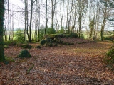
Huerta Montero is a burial chamber in the community of Almendralejo, Province of Badajoz, region of Extremadura
You may be viewing yesterday's version of this page. To see the most up to date information please register for a free account.
")
Do not use the above information on other web sites or publications without permission of the contributor.
Nearby Images from Flickr


The above images may not be of the site on this page, but were taken nearby. They are loaded from Flickr so please click on them for image credits.
Click here to see more info for this site
Nearby sites
Click here to view sites on an interactive map of the areaKey: Red: member's photo, Blue: 3rd party photo, Yellow: other image, Green: no photo - please go there and take one, Grey: site destroyed
Download sites to:
KML (Google Earth)
GPX (GPS waypoints)
CSV (Garmin/Navman)
CSV (Excel)
To unlock full downloads you need to sign up as a Contributory Member. Otherwise downloads are limited to 50 sites.
Turn off the page maps and other distractions
Nearby sites listing. In the following links * = Image available
7.6km SW 230° Pieza del Librito Burial Chamber or Dolmen
19.0km WSW 245° Dehesa las Yeguas Burial Chamber or Dolmen
24.4km NNE 18° Lauriana Burial Chamber or Dolmen
24.5km NNE 18° Lacara 2 Burial Chamber or Dolmen
24.5km WNW 301° La Pijotilla 1 Burial Chamber or Dolmen
24.5km NNE 18° Lacara Castro or Chafurdão
24.6km NNE 18° Sequero 1 Castro or Chafurdão
24.8km NNE 18° Canchal de Sequero 2 Castro or Chafurdão
25.7km NNE 14° Alcazaba de Mérida Ancient Village or Settlement
26.5km SSW 205° Casa del Monje* Burial Chamber or Dolmen
29.8km NW 325° Canchal de Sequero 3 Castro or Chafurdão
36.1km WSW 256° Dehesa de Enmedio Burial Chamber or Dolmen
36.1km WSW 256° Canada de la Murta Burial Chamber or Dolmen
37.0km SSW 197° Cortijo del Bonal Burial Chamber or Dolmen
38.3km SW 231° Dolmen Monteporrino (14)* Burial Chamber or Dolmen
38.3km SW 230° Dolmen Monteporrino (13)* Burial Chamber or Dolmen
38.4km SW 230° Menhir Monteporrino Standing Stone (Menhir)
38.8km SW 231° Dolmen Monteporrino (12) Burial Chamber or Dolmen
38.9km SW 234° Dolmen Monteporrino (1)* Burial Chamber or Dolmen
38.9km SW 232° Dolmen Monteporrino (3) Burial Chamber or Dolmen
39.0km SW 232° Dolmen Monteporrino (4)* Burial Chamber or Dolmen
39.2km SW 232° Dolmen Monteporrino (5)* Burial Chamber or Dolmen
39.2km SW 232° Dolmen Monteporrino (7) Burial Chamber or Dolmen
39.3km SW 232° Dolmen Monteporrino (6)* Burial Chamber or Dolmen
39.3km WSW 247° El Palacio Dolmen Burial Chamber or Dolmen
View more nearby sites and additional images


 We would like to know more about this location. Please feel free to add a brief description and any relevant information in your own language.
 Wir möchten mehr über diese Stätte erfahren. Bitte zögern Sie nicht, eine kurze Beschreibung und relevante Informationen in Deutsch hinzuzufügen.
 Nous aimerions en savoir encore un peu sur les lieux. S'il vous plaît n'hesitez pas à ajouter une courte description et tous les renseignements pertinents dans votre propre langue.
 Quisieramos informarnos un poco más de las lugares. No dude en añadir una breve descripción y otros datos relevantes en su propio idioma.