


<< Our Photo Pages >> Teampull - Misc. Earthwork in Scotland in Isle of Lewis
Submitted by mafenty on Tuesday, 22 August 2006 Page Views: 3568
Multi-periodSite Name: TeampullCountry: Scotland
NOTE: This site is 5.041 km away from the location you searched for.
County: Isle of Lewis Type: Misc. Earthwork
Nearest Town: STORNOWAY Nearest Village: LOWER BAYBLE
Map Ref: NB50782924
Latitude: 58.181381N Longitude: 6.240999W
Condition:
| 5 | Perfect |
| 4 | Almost Perfect |
| 3 | Reasonable but with some damage |
| 2 | Ruined but still recognisable as an ancient site |
| 1 | Pretty much destroyed, possibly visible as crop marks |
| 0 | No data. |
| -1 | Completely destroyed |
| 5 | Superb |
| 4 | Good |
| 3 | Ordinary |
| 2 | Not Good |
| 1 | Awful |
| 0 | No data. |
| 5 | Can be driven to, probably with disabled access |
| 4 | Short walk on a footpath |
| 3 | Requiring a bit more of a walk |
| 2 | A long walk |
| 1 | In the middle of nowhere, a nightmare to find |
| 0 | No data. |
| 5 | co-ordinates taken by GPS or official recorded co-ordinates |
| 4 | co-ordinates scaled from a detailed map |
| 3 | co-ordinates scaled from a bad map |
| 2 | co-ordinates of the nearest village |
| 1 | co-ordinates of the nearest town |
| 0 | no data |
Internal Links:
External Links:
")
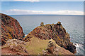
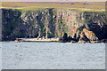
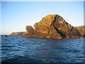
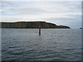
Remaining outline of 7th C chapel.. one of many such sites in Western Isles ..... interesting etymological point... Chicken Head, the site of the chapel, seems to have been mistranslated from the Norse " kirja" (a chapel) through Gaelic as "circe" (a chicken) to give the current English place name
You may be viewing yesterday's version of this page. To see the most up to date information please register for a free account.
Do not use the above information on other web sites or publications without permission of the contributor.
Nearby Images from Geograph Britain and Ireland:
©2009(licence)
©2023(licence)
©2009(licence)
©2007(licence)
©2008(licence)
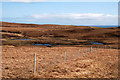
The above images may not be of the site on this page, they are loaded from Geograph.
Please Submit an Image of this site or go out and take one for us!
Click here to see more info for this site
Nearby sites
Key: Red: member's photo, Blue: 3rd party photo, Yellow: other image, Green: no photo - please go there and take one, Grey: site destroyed
Download sites to:
KML (Google Earth)
GPX (GPS waypoints)
CSV (Garmin/Navman)
CSV (Excel)
To unlock full downloads you need to sign up as a Contributory Member. Otherwise downloads are limited to 50 sites.
Turn off the page maps and other distractions
Nearby sites listing. In the following links * = Image available
1.5km NNE 33° Loch an Duin (Eye Peninsula)* Stone Fort or Dun (NB51683043)
4.1km NNE 19° Cnoc Nan Dursainean* Cairn (NB52383307)
4.6km NNE 22° Garrabost* Standing Stone (Menhir) (NB52813340)
11.3km WNW 298° Priest's Glen* Stone Circle (NB41103516)
11.4km WNW 301° Benside Newmarket* Stone Circle (NB4129735652)
11.9km WNW 291° Loch Airidh Na Lic* Crannog (NB39923410)
12.6km W 272° Druim Dubh* Stone Circle (NB382305)
13.6km SW 228° Dun Cromore* Stone Fort or Dun (NB4012320699)
14.4km N 351° Dun Beinn Ivor Stone Fort or Dun (NB495436)
14.6km N 0° Dun Beinn Earba Stone Fort or Dun (NB518438)
15.0km NNW 343° Carn A' Mharc Chambered Cairn (NB4722543846)
15.2km SW 228° Torastay* Cairn (NB38881976)
19.0km W 266° Achmore* Stone Circle (NB31742926)
24.1km WSW 241° Cnoc nan Clach (Hillock of Stone)* Cairn (NB2886718971)
26.0km W 269° Callanish 6* Standing Stones (NB24653034)
26.1km WSW 238° Loch Seaforth* Stone Circle (NB2782216637)
26.3km W 266° Callanish 18* Standing Stone (Menhir) (NB24402923)
27.1km W 272° Callanish 17* Stone Circle (NB237320)
27.2km NNW 332° Steinacleit* Chambered Tomb (NB39635408)
27.2km W 268° Callanish 5* Stone Row / Alignment (NB23432990)
27.4km W 267° Callanish 9* Standing Stones (NB233297)
27.5km W 268° Callanish 7* Ancient Mine, Quarry or other Industry (NB232302)
27.5km NW 317° Barabhas* Modern Stone Circle etc (NB333506)
27.5km NNW 332° Loch an Dùin (Shader)* Broch or Nuraghe (NB39295435)
27.6km NNW 333° Clach Stei Lin* Stone Circle (NB3969454546)
View more nearby sites and additional images


 We would like to know more about this location. Please feel free to add a brief description and any relevant information in your own language.
 Wir möchten mehr über diese Stätte erfahren. Bitte zögern Sie nicht, eine kurze Beschreibung und relevante Informationen in Deutsch hinzuzufügen.
 Nous aimerions en savoir encore un peu sur les lieux. S'il vous plaît n'hesitez pas à ajouter une courte description et tous les renseignements pertinents dans votre propre langue.
 Quisieramos informarnos un poco más de las lugares. No dude en añadir una breve descripción y otros datos relevantes en su propio idioma.