


<< Text Pages >> Dun Gallain (Colonsay) - Hillfort in Scotland in Isle of Colonsay
Submitted by Anne T on Tuesday, 15 August 2017 Page Views: 924
Iron Age and Later PrehistorySite Name: Dun Gallain (Colonsay)Country: Scotland County: Isle of Colonsay Type: Hillfort
Nearest Village: Machrins
Map Ref: NR34869314
Latitude: 56.057418N Longitude: 6.26048W
Condition:
| 5 | Perfect |
| 4 | Almost Perfect |
| 3 | Reasonable but with some damage |
| 2 | Ruined but still recognisable as an ancient site |
| 1 | Pretty much destroyed, possibly visible as crop marks |
| 0 | No data. |
| -1 | Completely destroyed |
| 5 | Superb |
| 4 | Good |
| 3 | Ordinary |
| 2 | Not Good |
| 1 | Awful |
| 0 | No data. |
| 5 | Can be driven to, probably with disabled access |
| 4 | Short walk on a footpath |
| 3 | Requiring a bit more of a walk |
| 2 | A long walk |
| 1 | In the middle of nowhere, a nightmare to find |
| 0 | No data. |
| 5 | co-ordinates taken by GPS or official recorded co-ordinates |
| 4 | co-ordinates scaled from a detailed map |
| 3 | co-ordinates scaled from a bad map |
| 2 | co-ordinates of the nearest village |
| 1 | co-ordinates of the nearest town |
| 0 | no data |
Be the first person to rate this site - see the 'Contribute!' box in the right hand menu.
Internal Links:
External Links:
Hillfort in Argyll
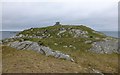
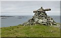
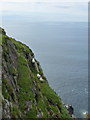
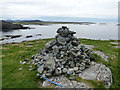
The remains of this hillfort, to the west of Colonsay airfield, are recorded as Canmore ID 37978. An extract of their entry reads: "This fort occupies a commanding position at the w end of a rocky promontory 1.8km W of Machrins. The summit is defended by an oval wall, enclosing an area about 30m by 20m with an outer wall on the E and s sides. The main wall is best preserved on the E and S sides, where it is about 3m thick and 0.7m high in five courses; at one point on the NE a stretch of medial face is visible a short distance S of the entrance, which faces NE. Two of the facing-stones of the NW side-wall of the passage appear to be still in position. There is a modern marker cairn on the highest point of the interior. The outer wall runs along the crest of a rocky ridge on the E side and along the lower flanks of the summit on the SE, where long stretches of the outer face are visible; its course on the S, however, is largely masked by rubble, and on the W and N the sheer cliffs made any secondary defence unnecessary. There is a gap in the wall-debris on the NE in line with the entrance through the main wall, but a single large outer facing-stone shows that the outwork continued to the cliff-edge."
The Northern Antiquarian (TNA)also has a page for this site - see their entry for Dun Gallain, Colonsay, Argyll, which describes this as a "Bittova trek this one". The TNA page contains directions for finding this hillfort together with a brief archaeology & history and local folklore. They add: "Interestingly, there is a long-cist burial at Machrins (plus small settlement) a few hundred yards east of the fort, and excavations here found them to date from the Viking period; though the Scottish Royal Commission thought that although the 'small finds associated with the burial suggest that it is Viking, the plan-form of the houses is perhaps more likely to indicate a native tradition.'"
Note: Have you visited this site? Do you have any photographs or further information you can add?
You may be viewing yesterday's version of this page. To see the most up to date information please register for a free account.
Do not use the above information on other web sites or publications without permission of the contributor.
Nearby Images from Geograph Britain and Ireland:
©2017(licence)
©2017(licence)
©2013(licence)
©2013(licence)
©2013(licence)
The above images may not be of the site on this page, they are loaded from Geograph.
Please Submit an Image of this site or go out and take one for us!
Click here to see more info for this site
Nearby sites
Key: Red: member's photo, Blue: 3rd party photo, Yellow: other image, Green: no photo - please go there and take one, Grey: site destroyed
Download sites to:
KML (Google Earth)
GPX (GPS waypoints)
CSV (Garmin/Navman)
CSV (Excel)
To unlock full downloads you need to sign up as a Contributory Member. Otherwise downloads are limited to 50 sites.
Turn off the page maps and other distractions
Nearby sites listing. In the following links * = Image available
1.2km NE 49° Tobar Fuar* Stone Fort or Dun (NR35799384)
1.9km E 85° Machrins Stone* Sculptured Stone (NR36769320)
2.5km SE 136° Garvard Standing Stone Standing Stone (Menhir) (NR36479126)
2.5km NE 43° Fingal's Limpet Hammers* Standing Stones (NR367949)
3.1km ESE 108° Dunan Nan Con* Stone Fort or Dun (NR37739201)
3.3km E 81° Dunan Leathan* Stone Fort or Dun (NR38119347)
3.3km ESE 116° Dun Cholla* Stone Fort or Dun (NR3777091520)
3.6km ENE 66° Dun Eibhinn* Stone Fort or Dun (NR38229439)
3.8km ENE 77° Scalasaig South* Stone Circle (NR38669376)
3.8km ENE 70° Scalasaig Farm Standing Stone (Menhir) (NR38569421)
4.1km E 83° Queens Bay Dun* Stone Fort or Dun (NR38929341)
4.1km S 169° Dun Domhnuill Stone Fort or Dun (NR35418902)
4.2km ENE 69° Buaile Riabhach* Cairn (NR3884594358)
4.3km ENE 61° Beinn Nan Gudairean Stone Fort or Dun (NR38809498)
4.7km ENE 73° Scalasaig Dun* Stone Fort or Dun (NR39479426)
5.2km SSE 166° Oronsay Shell Middens* Ancient Village or Settlement (NR35828797)
6.0km NE 49° St Oran's Well (Colonsay) Holy Well or Sacred Spring (NR3959096818)
8.0km NE 53° Dunan Nan Nighean* Stone Fort or Dun (NR4155897608)
10.0km NE 48° Cnoc A'Charragh Standing Stone (Menhir) (NR42669940)
21.5km SSW 194° Ardnave Loch* Crannog (NR28317263)
22.5km SSW 193° St Nem's Churchyard (Kilnave)* Ancient Cross (NR285715)
23.3km S 177° Clach an Tiompain Standing Stone (Menhir) (NR34756977)
24.9km SSE 166° Finlaggan* Standing Stone (Menhir) (NR3927668559)
25.2km S 176° Beinn Cham Standing Stones (NR349679)
25.5km S 173° Baile Tarbhach Standing Stone (Menhir) (NR36366762)
View more nearby sites and additional images


 We would like to know more about this location. Please feel free to add a brief description and any relevant information in your own language.
 Wir möchten mehr über diese Stätte erfahren. Bitte zögern Sie nicht, eine kurze Beschreibung und relevante Informationen in Deutsch hinzuzufügen.
 Nous aimerions en savoir encore un peu sur les lieux. S'il vous plaît n'hesitez pas à ajouter une courte description et tous les renseignements pertinents dans votre propre langue.
 Quisieramos informarnos un poco más de las lugares. No dude en añadir una breve descripción y otros datos relevantes en su propio idioma.