 with our Megalithic Portal iPhone app")


<< Other Photo Pages >> Baltray - Standing Stones in Ireland (Republic of) in Co. Louth
Submitted by vicky on Sunday, 22 December 2002 Page Views: 7443
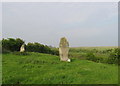
Neolithic and Bronze AgeSite Name: BaltrayCountry: Ireland (Republic of)
NOTE: This site is 4.559 km away from the location you searched for.
County: Co. Louth Type: Standing Stones
Discovery Map Number: D36
Latitude: 53.740696N Longitude: 6.265837W
Condition:
| 5 | Perfect |
| 4 | Almost Perfect |
| 3 | Reasonable but with some damage |
| 2 | Ruined but still recognisable as an ancient site |
| 1 | Pretty much destroyed, possibly visible as crop marks |
| 0 | No data. |
| -1 | Completely destroyed |
| 5 | Superb |
| 4 | Good |
| 3 | Ordinary |
| 2 | Not Good |
| 1 | Awful |
| 0 | No data. |
| 5 | Can be driven to, probably with disabled access |
| 4 | Short walk on a footpath |
| 3 | Requiring a bit more of a walk |
| 2 | A long walk |
| 1 | In the middle of nowhere, a nightmare to find |
| 0 | No data. |
| 5 | co-ordinates taken by GPS or official recorded co-ordinates |
| 4 | co-ordinates scaled from a detailed map |
| 3 | co-ordinates scaled from a bad map |
| 2 | co-ordinates of the nearest village |
| 1 | co-ordinates of the nearest town |
| 0 | no data |
Internal Links:
External Links:
Pair of Standing Stones in Co.Louth
Have you visited this site? Please add a comment below.
You may be viewing yesterday's version of this page. To see the most up to date information please register for a free account.
Do not use the above information on other web sites or publications without permission of the contributor.
davidmorgan has found this location on Google Street View:
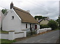
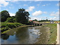
Nearby Images from Geograph Britain and Ireland:
©2008(licence)
©2008(licence)
©2009(licence)
©2008(licence)
©2021(licence)
The above images may not be of the site on this page, they are loaded from Geograph.
Please Submit an Image of this site or go out and take one for us!
Click here to see more info for this site
Nearby sites
Click here to view sites on an interactive map of the areaKey: Red: member's photo, Blue: 3rd party photo, Yellow: other image, Green: no photo - please go there and take one, Grey: site destroyed
Download sites to:
KML (Google Earth)
GPX (GPS waypoints)
CSV (Garmin/Navman)
CSV (Excel)
To unlock full downloads you need to sign up as a Contributory Member. Otherwise downloads are limited to 50 sites.
Turn off the page maps and other distractions
Nearby sites listing. In the following links * = Image available
6.4km WSW 240° Millmount* Artificial Mound
9.3km WSW 255° Oldbridge Logboat, River Boyne Not Known (by us)
10.7km WNW 292° Muiredach's Cross (Monasterboice)* Ancient Cross (O044820)
11.7km WSW 252° Dowth Henge* Henge (O034742)
12.0km WSW 249° Donore Mystery Mound Artificial Mound (O0334573550)
12.1km WSW 251° Dowth Hall* Passage Grave
12.2km SSE 165° Knocknagin* Passage Grave
12.5km W 260° Townleyhall Passage Tomb* Passage Grave (O0222075723)
12.8km WSW 251° Dowth Passage Grave* Passage Grave (O02377377)
13.2km SSE 158° Bremore Port* Passage Grave
14.0km WSW 248° Newgrange Standing Stones* Standing Stones
14.7km WSW 250° Newgrange* Passage Grave (O00747272)
14.8km WSW 250° Newgrange Stone Circle* Stone Circle (O007727)
14.9km SSW 195° Greenanstown Stone Circle (O110637)
14.9km WNW 292° Tinure* Rock Art (O005835)
15.2km WSW 248° Recently Discovered Prehistoric Cropmark near Newgrange* Misc. Earthwork
15.5km WSW 253° Knowth Timber Circle* Timber Circle (N997734)
15.5km WSW 254° Knowth* Passage Grave (N99697342)
15.7km SSW 197° Micknanstown* Passage Grave
16.5km SSW 194° Fourknocks* Passage Grave (O10856202)
18.6km W 262° Hill of Slane* Artificial Mound
19.8km W 277° Grangegeeth Sculptured Stone
21.4km SE 144° St Patrick's Island Early Christian Sculptured Stone
22.2km WNW 296° Hurlstone* Holed Stone (N9426987509)
24.1km SSW 213° Kilbrew Henge
View more nearby sites and additional images


 We would like to know more about this location. Please feel free to add a brief description and any relevant information in your own language.
 Wir möchten mehr über diese Stätte erfahren. Bitte zögern Sie nicht, eine kurze Beschreibung und relevante Informationen in Deutsch hinzuzufügen.
 Nous aimerions en savoir encore un peu sur les lieux. S'il vous plaît n'hesitez pas à ajouter une courte description et tous les renseignements pertinents dans votre propre langue.
 Quisieramos informarnos un poco más de las lugares. No dude en añadir una breve descripción y otros datos relevantes en su propio idioma.