


<< Text Pages >> La Cancha - Burial Chamber or Dolmen in Spain in Extremadura
Submitted by TheCaptain on Wednesday, 08 September 2010 Page Views: 1502
Neolithic and Bronze AgeSite Name: La CanchaCountry: Spain
NOTE: This site is 0.828 km away from the location you searched for.
Region: Extremadura Type: Burial Chamber or Dolmen
Nearest Town: Caceres Nearest Village: Montanchez
Latitude: 39.217000N Longitude: 6.15W
Condition:
| 5 | Perfect |
| 4 | Almost Perfect |
| 3 | Reasonable but with some damage |
| 2 | Ruined but still recognisable as an ancient site |
| 1 | Pretty much destroyed, possibly visible as crop marks |
| 0 | No data. |
| -1 | Completely destroyed |
| 5 | Superb |
| 4 | Good |
| 3 | Ordinary |
| 2 | Not Good |
| 1 | Awful |
| 0 | No data. |
| 5 | Can be driven to, probably with disabled access |
| 4 | Short walk on a footpath |
| 3 | Requiring a bit more of a walk |
| 2 | A long walk |
| 1 | In the middle of nowhere, a nightmare to find |
| 0 | No data. |
| 5 | co-ordinates taken by GPS or official recorded co-ordinates |
| 4 | co-ordinates scaled from a detailed map |
| 3 | co-ordinates scaled from a bad map |
| 2 | co-ordinates of the nearest village |
| 1 | co-ordinates of the nearest town |
| 0 | no data |
Be the first person to rate this site - see the 'Contribute!' box in the right hand menu.
Internal Links:
External Links:
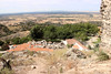
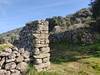
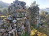
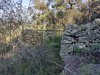
Burial chamber in Extremadura
La Cancha is a burial chamber in the community of Montanchez, Province of Caceres, region of Extremadura
You may be viewing yesterday's version of this page. To see the most up to date information please register for a free account.
Do not use the above information on other web sites or publications without permission of the contributor.
Nearby Images from Flickr
The above images may not be of the site on this page, but were taken nearby. They are loaded from Flickr so please click on them for image credits.
Click here to see more info for this site
Nearby sites
Click here to view sites on an interactive map of the areaKey: Red: member's photo, Blue: 3rd party photo, Yellow: other image, Green: no photo - please go there and take one, Grey: site destroyed
Download sites to:
KML (Google Earth)
GPX (GPS waypoints)
CSV (Garmin/Navman)
CSV (Excel)
To unlock full downloads you need to sign up as a Contributory Member. Otherwise downloads are limited to 50 sites.
Turn off the page maps and other distractions
Nearby sites listing. In the following links * = Image available
10.3km SE 136° Burdalo 2 Burial Chamber or Dolmen
10.3km SE 136° Burdalo 1 Burial Chamber or Dolmen
13.7km NE 47° Salvatierra de Santiago Burial Chamber or Dolmen
17.6km WSW 251° Carmonita Dolmen* Burial Chamber or Dolmen
17.8km NNW 336° Redondilla Burial Chamber or Dolmen
18.5km WNW 302° Garabato Dolmen* Burial Chamber or Dolmen
21.0km NW 314° Herguijiela Burial Chamber or Dolmen
22.9km ENE 61° Astorganas Burial Chamber or Dolmen
29.9km SW 232° Dolmen de Lácara* Burial Chamber or Dolmen
30.0km NW 321° Cueva de Santa Ana Cave or Rock Shelter
32.8km NW 325° Cueva de Maltravieso* Rock Art
32.9km WNW 302° La Mogollona Burial Chamber or Dolmen
34.2km NNW 326° Cáceres Museum* Museum
34.5km WSW 241° La Nava de Santiago Burial Chamber or Dolmen
34.6km WNW 303° Hijadilla Dolmen 1 Burial Chamber or Dolmen
34.8km NW 314° Yacimiento Arqueológico de El Millar Ancient Village or Settlement
35.0km NNW 328° Castro de Valdeagudo Castro or Chafurdão
35.0km WNW 303° Hijadilla Dolmen 2 Burial Chamber or Dolmen
35.1km NNW 328° Las Seguras Burial Chamber or Dolmen
35.3km WNW 303° Hijadilla Dolmen 3 Burial Chamber or Dolmen
35.4km NE 41° Trujillo Burial Chamber or Dolmen
37.7km SSW 207° Alcazaba de Mérida Ancient Village or Settlement
38.3km SSW 204° Canchal de Sequero 2 Castro or Chafurdão
38.4km SSW 204° Sequero 1 Castro or Chafurdão
38.4km SE 140° Don Benito Burial Chamber or Dolmen
View more nearby sites and additional images


 We would like to know more about this location. Please feel free to add a brief description and any relevant information in your own language.
 Wir möchten mehr über diese Stätte erfahren. Bitte zögern Sie nicht, eine kurze Beschreibung und relevante Informationen in Deutsch hinzuzufügen.
 Nous aimerions en savoir encore un peu sur les lieux. S'il vous plaît n'hesitez pas à ajouter une courte description et tous les renseignements pertinents dans votre propre langue.
 Quisieramos informarnos un poco más de las lugares. No dude en añadir una breve descripción y otros datos relevantes en su propio idioma.