


<< Other Photo Pages >> Dun Ban (Doune) - Stone Fort or Dun in Scotland in Highlands
Submitted by Andy B on Tuesday, 19 October 2010 Page Views: 3738
Multi-periodSite Name: Dun Ban (Doune)Country: Scotland
NOTE: This site is 7.212 km away from the location you searched for.
County: Highlands Type: Stone Fort or Dun
Map Ref: NG70110362
Latitude: 57.066064N Longitude: 5.793702W
Condition:
| 5 | Perfect |
| 4 | Almost Perfect |
| 3 | Reasonable but with some damage |
| 2 | Ruined but still recognisable as an ancient site |
| 1 | Pretty much destroyed, possibly visible as crop marks |
| 0 | No data. |
| -1 | Completely destroyed |
| 5 | Superb |
| 4 | Good |
| 3 | Ordinary |
| 2 | Not Good |
| 1 | Awful |
| 0 | No data. |
| 5 | Can be driven to, probably with disabled access |
| 4 | Short walk on a footpath |
| 3 | Requiring a bit more of a walk |
| 2 | A long walk |
| 1 | In the middle of nowhere, a nightmare to find |
| 0 | No data. |
| 5 | co-ordinates taken by GPS or official recorded co-ordinates |
| 4 | co-ordinates scaled from a detailed map |
| 3 | co-ordinates scaled from a bad map |
| 2 | co-ordinates of the nearest village |
| 1 | co-ordinates of the nearest town |
| 0 | no data |
Be the first person to rate this site - see the 'Contribute!' box in the right hand menu.
Internal Links:
External Links:
 (PID:110898)")
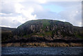
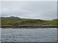
Dun Ban, the remains of a vitrified fort on a cliff-girt peninsula, is pear-shaped on plan and measures c. 74.0m. NNW to SSE by c. 49.0m transversely within a heavily vitrified wall. Except in the NW, where it cannot be traced, the wall is visible around the cliff top as a turf-covered scarp from which numerous lumps of vitrified rock protrude. The entrance is not evident but may have been in the S at the easiest approach. Here a few earth-fast stones, probably the base course of the outer face, are visible. No wall thickness can be ascertained. The interior is featureless.
Source: Canmore
You may be viewing yesterday's version of this page. To see the most up to date information please register for a free account.
Do not use the above information on other web sites or publications without permission of the contributor.
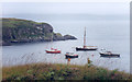
Nearby Images from Geograph Britain and Ireland:
©2008(licence)
©2011(licence)

©2015(licence)

©2015(licence)
©2015(licence)
The above images may not be of the site on this page, they are loaded from Geograph.
Please Submit an Image of this site or go out and take one for us!
Click here to see more info for this site
Nearby sites
Key: Red: member's photo, Blue: 3rd party photo, Yellow: other image, Green: no photo - please go there and take one, Grey: site destroyed
Download sites to:
KML (Google Earth)
GPX (GPS waypoints)
CSV (Garmin/Navman)
CSV (Excel)
To unlock full downloads you need to sign up as a Contributory Member. Otherwise downloads are limited to 50 sites.
Turn off the page maps and other distractions
Nearby sites listing. In the following links * = Image available
5.0km NNW 336° Dun Choinnich* Broch or Nuraghe (NG68290834)
5.3km NW 306° Dun Faich Stone Fort or Dun (NG66020697)
5.8km WNW 288° Dun Ela* Stone Fort or Dun (NG64640569)
6.1km W 268° Cists near Armadale Pier Burial Chamber or Dolmen (NG640038)
6.4km W 269° Armadale Bay Cairn Cairn (NG63680390)
6.5km NNW 337° Dun Knock (Toravaig)* Stone Fort or Dun (NG679098)
6.9km W 262° Dun Acardinon* Stone Fort or Dun (NG63250305)
7.0km N 357° Dun Ban (Camascross) Stone Fort or Dun (NG70121065)
8.5km WSW 252° Dun Chlo (Tormore)* Stone Fort or Dun (NG618015)
9.9km WSW 251° Dun A'Chleirich* Stone Fort or Dun (NG60590091)
10.5km WSW 249° Dun Ban (Sleat)* Stone Fort or Dun (NG60030042)
11.1km NW 316° Meal-da-Bheinn* Stone Circle (NG629121)
12.6km NW 316° Teampuill Chaon* Early Christian Sculptured Stone (NG61831321)
12.9km NW 316° Tobar Chaon* Holy Well or Sacred Spring (NG61711340)
12.9km WNW 298° Cnoc an Temple* Burial Chamber or Dolmen (NG591104)
13.1km NW 310° Inver Aulavaig 2* Cairn (NG6059112629)
13.2km NW 310° Inver Aulavaig 1* Cairn (NG60441259)
13.4km W 272° Dun Geilbt Stone Fort or Dun (NG56750480)
15.1km NNW 337° Heaste Stone Standing Stone (Menhir) (NG6505117847)
15.1km NW 324° Dun Boreraig Stone* Standing Stone (Menhir) (NG61951638)
15.2km NW 322° Dun Boreraig Fort* Hillfort (NG615162)
17.4km NW 320° Dun Kearstack* Hillfort (NG596175)
18.5km NNW 331° Kilchrist, Glebe* Stone Circle (NG61972027)
18.6km NE 40° Dun Telve* Broch or Nuraghe (NG829172)
18.6km WNW 294° Dun Grugaig (Skye)* Stone Fort or Dun (NG53541229)
View more nearby sites and additional images


 We would like to know more about this location. Please feel free to add a brief description and any relevant information in your own language.
 Wir möchten mehr über diese Stätte erfahren. Bitte zögern Sie nicht, eine kurze Beschreibung und relevante Informationen in Deutsch hinzuzufügen.
 Nous aimerions en savoir encore un peu sur les lieux. S'il vous plaît n'hesitez pas à ajouter une courte description et tous les renseignements pertinents dans votre propre langue.
 Quisieramos informarnos un poco más de las lugares. No dude en añadir una breve descripción y otros datos relevantes en su propio idioma.