


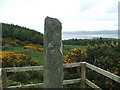
<< Our Photo Pages >> Cnoc na Carraigh Ogham Stone - Sculptured Stone in Scotland in Argyll
Submitted by DavidHoyle on Tuesday, 30 May 2023 Page Views: 353
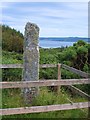
Multi-periodSite Name: Cnoc na Carraigh Ogham StoneCountry: Scotland County: Argyll Type: Sculptured Stone
Nearest Village: Isle of Gigha
Map Ref: NR6426548173
Latitude: 55.669657N Longitude: 5.750275W
Condition:
| 5 | Perfect |
| 4 | Almost Perfect |
| 3 | Reasonable but with some damage |
| 2 | Ruined but still recognisable as an ancient site |
| 1 | Pretty much destroyed, possibly visible as crop marks |
| 0 | No data. |
| -1 | Completely destroyed |
| 5 | Superb |
| 4 | Good |
| 3 | Ordinary |
| 2 | Not Good |
| 1 | Awful |
| 0 | No data. |
| 5 | Can be driven to, probably with disabled access |
| 4 | Short walk on a footpath |
| 3 | Requiring a bit more of a walk |
| 2 | A long walk |
| 1 | In the middle of nowhere, a nightmare to find |
| 0 | No data. |
| 5 | co-ordinates taken by GPS or official recorded co-ordinates |
| 4 | co-ordinates scaled from a detailed map |
| 3 | co-ordinates scaled from a bad map |
| 2 | co-ordinates of the nearest village |
| 1 | co-ordinates of the nearest town |
| 0 | no data |
Internal Links:
External Links:
")
Ogham Stone. https://canmore.org.uk/site/38529/gigha-cnoc-na-carraigh
You may be viewing yesterday's version of this page. To see the most up to date information please register for a free account.
")
Do not use the above information on other web sites or publications without permission of the contributor.
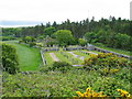
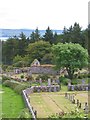
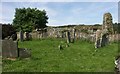
Nearby Images from Geograph Britain and Ireland:
©2006(licence)
©2011(licence)
©2006(licence)
©2005(licence)
©2011(licence)
The above images may not be of the site on this page, they are loaded from Geograph.
Please Submit an Image of this site or go out and take one for us!
Click here to see more info for this site
Nearby sites
Key: Red: member's photo, Blue: 3rd party photo, Yellow: other image, Green: no photo - please go there and take one, Grey: site destroyed
Download sites to:
KML (Google Earth)
GPX (GPS waypoints)
CSV (Garmin/Navman)
CSV (Excel)
To unlock full downloads you need to sign up as a Contributory Member. Otherwise downloads are limited to 50 sites.
Turn off the page maps and other distractions
Nearby sites listing. In the following links * = Image available
130m SSW 207° Cnoc na Carraigh (Gigha) Standing Stone (Menhir) (NR64204806)
164m NE 46° Cnoc na Croise (Gigha) Cairn (NR64394828)
987m SSW 205° Bodach and Cailleach* Standing Stones (NR638473)
996m NE 40° Ardminish Cist (NR64954890)
1.2km W 271° Ardlamey Cairn (NR63094825)
1.5km NNE 11° Druimyeonbeg (Isle of Gigha) Cairn (NR64634958)
4.3km NNE 14° Tarbert (Gigha)* Standing Stone (Menhir) (NR6554952292)
4.4km NNE 13° Old Wife's Grave, The (Gigha, Isle of) Cairn (NR655524)
5.2km NNE 13° Kinerarach (Gigha)* Standing Stone (Menhir) (NR6568453210)
6.1km NNE 14° Cnoc nan Gobhar Stone* Standing Stone (Menhir) (NR6607454042)
6.9km SE 131° Beacharra* Standing Stone (Menhir) (NR69264332)
8.1km SE 139° North Beachmore (Muasdale) Standing Stone (Menhir) (NR69284184)
9.7km SSE 155° South Muasdale Standing Stone (Menhir) (NR6792239154)
9.8km ENE 61° Ballochroy* Stone Row / Alignment (NR7309352426)
10.1km SSE 162° Glencreggan (Glenbarr) Cairn (NR668384)
11.1km NE 55° Correchrevie Cairn* Cairn (NR738540)
11.3km SSE 168° Barlea Standing Stone (Menhir) (NR661370)
14.4km NE 53° Dun Skeig* Hillfort (NR76315612)
15.2km ENE 61° Loch Ciaran* Standing Stone (Menhir) (NR78035479)
15.9km SE 140° Ballynacloghy Portal tomb* Portal Tomb (D52348198)
16.0km SE 142° Beinn an Tuirc Standing Stone (Menhir) (NR73563507)
16.2km SE 134° Beinn an Tuirc Stone Circle (NR753362)
16.3km ESE 110° Brackley* Chambered Cairn (NR79374187)
16.5km NE 41° Ardpatrick* Standing Stone (Menhir) (NR757601)
16.7km NNE 33° Carse Standing Stones West* Standing Stone (Menhir) (NR74146166)
View more nearby sites and additional images


 We would like to know more about this location. Please feel free to add a brief description and any relevant information in your own language.
 Wir möchten mehr über diese Stätte erfahren. Bitte zögern Sie nicht, eine kurze Beschreibung und relevante Informationen in Deutsch hinzuzufügen.
 Nous aimerions en savoir encore un peu sur les lieux. S'il vous plaît n'hesitez pas à ajouter une courte description et tous les renseignements pertinents dans votre propre langue.
 Quisieramos informarnos un poco más de las lugares. No dude en añadir una breve descripción y otros datos relevantes en su propio idioma.