

<< Our Photo Pages >> Lochalsh - Stone Circle in Scotland in Highlands
Submitted by hamilton on Sunday, 02 June 2013 Page Views: 13637
Neolithic and Bronze AgeSite Name: LochalshCountry: Scotland County: Highlands Type: Stone Circle
Nearest Town: Kyle of Lochalsh Nearest Village: Balmacara
Map Ref: NG831274 Landranger Map Number: 33
Latitude: 57.285557N Longitude: 5.60062W
Condition:
| 5 | Perfect |
| 4 | Almost Perfect |
| 3 | Reasonable but with some damage |
| 2 | Ruined but still recognisable as an ancient site |
| 1 | Pretty much destroyed, possibly visible as crop marks |
| 0 | No data. |
| -1 | Completely destroyed |
| 5 | Superb |
| 4 | Good |
| 3 | Ordinary |
| 2 | Not Good |
| 1 | Awful |
| 0 | No data. |
| 5 | Can be driven to, probably with disabled access |
| 4 | Short walk on a footpath |
| 3 | Requiring a bit more of a walk |
| 2 | A long walk |
| 1 | In the middle of nowhere, a nightmare to find |
| 0 | No data. |
| 5 | co-ordinates taken by GPS or official recorded co-ordinates |
| 4 | co-ordinates scaled from a detailed map |
| 3 | co-ordinates scaled from a bad map |
| 2 | co-ordinates of the nearest village |
| 1 | co-ordinates of the nearest town |
| 0 | no data |
Internal Links:
External Links:
")
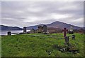
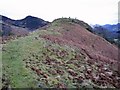
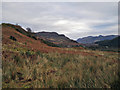
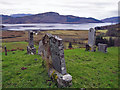
At the time of my visit in May 2012, the entire hillside was covered with grass, dead bracken and the odd gorse scrub, all well flattened by the previous winter's snow. You might expect that any large stones would have been clearly visible. However, this hillside is particularly bereft of boulders of any kind and only the two stones of this circle were found, both extremely earthfast, toppled on their sides, and well camouflaged with a covering of moss.
The north stone was some two metres long with at least half a metre visible above ground. The south stone was a little shorter.
You may be viewing yesterday's version of this page. To see the most up to date information please register for a free account.
")
")
")
")
Do not use the above information on other web sites or publications without permission of the contributor.
Nearby Images from Geograph Britain and Ireland:
©2012(licence)
©2012(licence)
©2012(licence)
©2012(licence)
©2012(licence)
The above images may not be of the site on this page, they are loaded from Geograph.
Please Submit an Image of this site or go out and take one for us!
Click here to see more info for this site
Nearby sites
Key: Red: member's photo, Blue: 3rd party photo, Yellow: other image, Green: no photo - please go there and take one, Grey: site destroyed
Download sites to:
KML (Google Earth)
GPX (GPS waypoints)
CSV (Garmin/Navman)
CSV (Excel)
To unlock full downloads you need to sign up as a Contributory Member. Otherwise downloads are limited to 50 sites.
Turn off the page maps and other distractions
Nearby sites listing. In the following links * = Image available
64m NE 36° Angels' Hill, Kirkton* Hillfort (NG83142745)
471m WNW 303° Dun Kirkton Stone Fort or Dun (NG82722768)
2.0km ENE 77° Dun Gleann Udalain Stone Fort or Dun (NG85062773)
2.8km NE 41° Gleann Udalain Cairn Cairn (NG85092942)
4.0km NNW 328° Loch Achaidh na h-Inich* Crannog (NG81173095)
4.2km NNW 340° Carn na Sean-chreige* Hillfort (NG81893146)
4.2km ESE 117° Dun Totaig (Loch Duich) Broch or Nuraghe (NG868253)
4.3km ESE 120° Caisteal Grugaig* Broch or Nuraghe (NG86692508)
4.8km ESE 112° Totaig Cup Markings* Rock Art (NG87432536)
6.7km S 185° Am Baghan Galldair* Stone Fort or Dun (NG82162075)
6.7km E 83° Bard's Castle* Hillfort (NG89822790)
6.8km SSW 199° Bernera Farm* Rock Art (NG80552110)
6.8km SE 127° Torran a'Bharraich* Hillfort (NG88312296)
7.3km ESE 110° Carr Brae* Rock Art (NG89782451)
7.3km SE 125° Allt an Inbhir Souterrain* Souterrain (Fogou, Earth House) (NG88882296)
7.3km SSE 163° Serpent Mound (Scallasaig) Cairn (NG8484020288)
7.7km S 182° An Dun (Barnhill)* Stone Fort or Dun (NG82441972)
9.6km W 268° Sligeanach Kildonan Stone Row / Alignment (NG735275)
10.1km S 177° Corrary Prehistoric Site* Cairn (NG83121725)
10.2km S 178° Dun Telve* Broch or Nuraghe (NG829172)
10.2km S 175° Dun Troddan* Broch or Nuraghe (NG834172)
10.8km S 172° Balvraid Farm Cup Marked Stone* Rock Art (NG84081667)
10.8km S 169° Balvraid Chambered Cairn* Chambered Cairn (NG8452416627)
11.2km SSE 167° Balvraid Cup Marked Stone* Rock Art (NG84961635)
11.4km SSE 167° Grugaig Hut Circle* Ancient Village or Settlement (NG8517616131)
View more nearby sites and additional images


 We would like to know more about this location. Please feel free to add a brief description and any relevant information in your own language.
 Wir möchten mehr über diese Stätte erfahren. Bitte zögern Sie nicht, eine kurze Beschreibung und relevante Informationen in Deutsch hinzuzufügen.
 Nous aimerions en savoir encore un peu sur les lieux. S'il vous plaît n'hesitez pas à ajouter une courte description et tous les renseignements pertinents dans votre propre langue.
 Quisieramos informarnos un poco más de las lugares. No dude en añadir una breve descripción y otros datos relevantes en su propio idioma.