


<< Our Photo Pages >> Trereife Cross - Ancient Cross in England in Cornwall
Submitted by davidmorgan on Wednesday, 17 September 2014 Page Views: 1491
Early Medieval (Dark Age)Site Name: Trereife CrossCountry: England
NOTE: This site is 0.77 km away from the location you searched for.
County: Cornwall Type: Ancient Cross
Nearest Town: Newlyn
Map Ref: SW4614229077
Latitude: 50.107393N Longitude: 5.551741W
Condition:
| 5 | Perfect |
| 4 | Almost Perfect |
| 3 | Reasonable but with some damage |
| 2 | Ruined but still recognisable as an ancient site |
| 1 | Pretty much destroyed, possibly visible as crop marks |
| 0 | No data. |
| -1 | Completely destroyed |
| 5 | Superb |
| 4 | Good |
| 3 | Ordinary |
| 2 | Not Good |
| 1 | Awful |
| 0 | No data. |
| 5 | Can be driven to, probably with disabled access |
| 4 | Short walk on a footpath |
| 3 | Requiring a bit more of a walk |
| 2 | A long walk |
| 1 | In the middle of nowhere, a nightmare to find |
| 0 | No data. |
| 5 | co-ordinates taken by GPS or official recorded co-ordinates |
| 4 | co-ordinates scaled from a detailed map |
| 3 | co-ordinates scaled from a bad map |
| 2 | co-ordinates of the nearest village |
| 1 | co-ordinates of the nearest town |
| 0 | no data |
Internal Links:
External Links:
I have visited· I would like to visit
lucasn visited - their rating: Cond: 4 Amb: 3 Access: 5
")
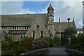
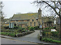
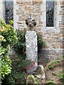
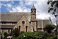
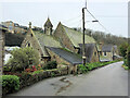
"Medieval Latin wayside cross found in a field at Trereife in 1870 later mounted on a modern shaft and base in Newlyn churchyard. The head is 0.47m high by 0.29m wide and 0.28m thick the overall height of the monument is 1.96m. Scheduled."
Pastscape monument no. 421976.
You may be viewing yesterday's version of this page. To see the most up to date information please register for a free account.
")
")
")
")
Do not use the above information on other web sites or publications without permission of the contributor.
Nearby Images from Geograph Britain and Ireland:
©2023(licence)
©2023(licence)
©2019(licence)
©2007(licence)
©2023(licence)
The above images may not be of the site on this page, they are loaded from Geograph.
Please Submit an Image of this site or go out and take one for us!
Click here to see more info for this site
Nearby sites
Key: Red: member's photo, Blue: 3rd party photo, Yellow: other image, Green: no photo - please go there and take one, Grey: site destroyed
Download sites to:
KML (Google Earth)
GPX (GPS waypoints)
CSV (Garmin/Navman)
CSV (Excel)
To unlock full downloads you need to sign up as a Contributory Member. Otherwise downloads are limited to 50 sites.
Turn off the page maps and other distractions
Nearby sites listing. In the following links * = Image available
425m N 352° Tolcarne (Mount Misery) Round Ancient Village or Settlement (SW461295)
1.0km WNW 299° Paul Downs Cross* Ancient Cross (SW45252963)
1.1km N 355° Castle Horneck Well* Holy Well or Sacred Spring (SW461302)
1.2km W 271° Trembath Cross* Ancient Cross (SW4489229156)
1.3km SW 224° Faughan* Standing Stones (SW45222822)
1.3km NE 40° Penzance Market Cross* Ancient Cross (SW47033003)
1.4km SW 230° Chyenhal Settlement Ancient Village or Settlement (SW450282)
1.5km NW 326° Lesingey Round* Hillfort (SW45353037)
1.5km W 262° Buryas Bridge menhir* Standing Stone (Menhir) (SW4459928947)
1.6km S 186° Sheffield* Standing Stone (Menhir) (SW459275)
1.7km NE 53° St Mary's Cross* Ancient Cross (SW47543001)
1.7km NW 307° Tremethick Cross* Ancient Cross (SW4483730144)
1.7km WSW 237° Ennis Farm Standing Stone* Standing Stone (Menhir) (SW44652821)
1.9km SW 232° Tresvennack Tumulus* Round Barrow(s) (SW446280)
1.9km SSW 212° Chyenhal* Standing Stone (Menhir) (SW45062751)
2.0km SSE 167° Paul Churchyard* Ancient Cross (SW465271)
2.0km NW 313° Parc-An-Growse Cross* Ancient Cross (SW44713055)
2.1km WSW 241° Tresvennack 2* Standing Stone (Menhir) (SW44252815)
2.3km WNW 282° Trewidden Round* Ancient Village or Settlement (SW43952967)
2.3km N 356° Heamoor Cross* Ancient Cross (SW46093136)
2.3km SW 236° Tresvennack Pillar* Standing Stone (Menhir) (SW44182787)
2.4km W 259° Lower Drift Cross* Ancient Cross (SW43752875)
2.4km SW 224° Kerris* Standing Stone (Menhir) (SW44392742)
2.4km NE 34° Lescudjack Castle* Hillfort (SW476310)
2.4km NNW 333° Nanceglos Well* Holy Well or Sacred Spring (SW45123130)
View more nearby sites and additional images


 We would like to know more about this location. Please feel free to add a brief description and any relevant information in your own language.
 Wir möchten mehr über diese Stätte erfahren. Bitte zögern Sie nicht, eine kurze Beschreibung und relevante Informationen in Deutsch hinzuzufügen.
 Nous aimerions en savoir encore un peu sur les lieux. S'il vous plaît n'hesitez pas à ajouter une courte description et tous les renseignements pertinents dans votre propre langue.
 Quisieramos informarnos un poco más de las lugares. No dude en añadir una breve descripción y otros datos relevantes en su propio idioma.