


<< Our Photo Pages >> St Hilary's inscribed stone - Sculptured Stone in England in Cornwall
Submitted by Bladup on Saturday, 10 January 2015 Page Views: 3980
Multi-periodSite Name: St Hilary's inscribed stoneCountry: England
NOTE: This site is 0.28 km away from the location you searched for.
County: Cornwall Type: Sculptured Stone
Map Ref: SW55033127
Latitude: 50.130814N Longitude: 5.429084W
Condition:
| 5 | Perfect |
| 4 | Almost Perfect |
| 3 | Reasonable but with some damage |
| 2 | Ruined but still recognisable as an ancient site |
| 1 | Pretty much destroyed, possibly visible as crop marks |
| 0 | No data. |
| -1 | Completely destroyed |
| 5 | Superb |
| 4 | Good |
| 3 | Ordinary |
| 2 | Not Good |
| 1 | Awful |
| 0 | No data. |
| 5 | Can be driven to, probably with disabled access |
| 4 | Short walk on a footpath |
| 3 | Requiring a bit more of a walk |
| 2 | A long walk |
| 1 | In the middle of nowhere, a nightmare to find |
| 0 | No data. |
| 5 | co-ordinates taken by GPS or official recorded co-ordinates |
| 4 | co-ordinates scaled from a detailed map |
| 3 | co-ordinates scaled from a bad map |
| 2 | co-ordinates of the nearest village |
| 1 | co-ordinates of the nearest town |
| 0 | no data |
Internal Links:
External Links:
I have visited· I would like to visit
lucasn visited - their rating: Cond: 5 Amb: 3 Access: 5
")
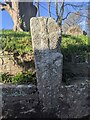
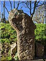
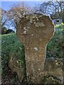
The stone is 1.9 metres high and 0.5 metres wide and stands to the East side of the path leading to the church. It is very well preserved and the inscription is clearly visible.
The inscription is pecked and rubbed on the W face of the stone. At the top are the letters a, w, with M (= Maria) between them, fantastically formed. Beneath is the name NOTI.
You may be viewing yesterday's version of this page. To see the most up to date information please register for a free account.
")
")
")
")
Do not use the above information on other web sites or publications without permission of the contributor.
Nearby Images from Geograph Britain and Ireland:
©2022(licence)
©2023(licence)
©2011(licence)
©2022(licence)
©2022(licence)
The above images may not be of the site on this page, they are loaded from Geograph.
Please Submit an Image of this site or go out and take one for us!
Click here to see more info for this site
Nearby sites
Key: Red: member's photo, Blue: 3rd party photo, Yellow: other image, Green: no photo - please go there and take one, Grey: site destroyed
Download sites to:
KML (Google Earth)
GPX (GPS waypoints)
CSV (Garmin/Navman)
CSV (Excel)
To unlock full downloads you need to sign up as a Contributory Member. Otherwise downloads are limited to 50 sites.
Turn off the page maps and other distractions
Nearby sites listing. In the following links * = Image available
1.5km ESE 122° Colenso Round* Ancient Village or Settlement (SW563304)
3.6km N 9° St Erth Round* Ancient Village or Settlement (SW55773477)
3.7km S 179° Cudden Point* Rock Outcrop (SW549276)
3.7km WSW 246° Giant's Well (St. Michael's Mount)* Holy Well or Sacred Spring (SW516299)
3.8km WSW 246° St Michael's Mount* Ancient Village or Settlement (SW515299)
3.8km NW 308° Tregender Cross* Ancient Cross (SW5212333747)
3.9km N 358° St Erth Cross* Ancient Cross (SW55073513)
3.9km WSW 245° St Michael's Mount crosses* Ancient Cross (SW514298)
3.9km WNW 287° Bowgyheere Barrow Cemetery* Barrow Cemetery (SW51313256)
4.0km ESE 116° St Germoe's Well* Holy Well or Sacred Spring (SW5855829374)
4.0km NW 318° Whitecross (Penwith)* Ancient Cross (SW5248534390)
4.2km E 90° Godolphin Hill* Ancient Village or Settlement (SW592311)
4.4km WNW 294° Crowlas holed stone* Holed Stone (SW51133325)
4.4km NW 319° Collurian Well Holy Well or Sacred Spring (SW523347)
4.5km NW 312° Tregellas Well* Holy Well or Sacred Spring (SW5183734388)
4.9km WNW 289° Ludgvan Crosses* Ancient Cross (SW50503305)
5.0km WNW 302° St Michael's standing stone* Modern Stone Circle etc (SW509341)
5.0km ESE 102° Castle Pencaire* Hillfort (SW599300)
5.2km E 98° Herland Round* Ancient Village or Settlement (SW60173032)
5.3km ESE 108° Tresoweshill Well* Holy Well or Sacred Spring (SW5999129381)
5.3km WNW 282° Tregarthen hedge stone* Standing Stone (Menhir) (SW4986332625)
5.4km E 101° Tregonning Hill Round* Ancient Village or Settlement (SW60273002)
5.4km NNW 349° Sea Lane Cross* Ancient Cross (SW54213661)
5.5km NE 34° Castle Kayle* Ancient Village or Settlement (SW58343565)
5.7km ESE 107° Tregonning hill tumulus* Round Cairn (SW604294)
View more nearby sites and additional images


 We would like to know more about this location. Please feel free to add a brief description and any relevant information in your own language.
 Wir möchten mehr über diese Stätte erfahren. Bitte zögern Sie nicht, eine kurze Beschreibung und relevante Informationen in Deutsch hinzuzufügen.
 Nous aimerions en savoir encore un peu sur les lieux. S'il vous plaît n'hesitez pas à ajouter une courte description et tous les renseignements pertinents dans votre propre langue.
 Quisieramos informarnos un poco más de las lugares. No dude en añadir una breve descripción y otros datos relevantes en su propio idioma.