 with our Megalithic Portal iPhone app")


<< Our Photo Pages >> North Connel Barrow - Round Barrow(s) in Scotland in Argyll
Submitted by ericjohn7 on Wednesday, 07 March 2012 Page Views: 4193
Neolithic and Bronze AgeSite Name: North Connel BarrowCountry: Scotland County: Argyll Type: Round Barrow(s)
Nearest Town: Oban Nearest Village: North Connel
Map Ref: NM90923471
Latitude: 56.458026N Longitude: 5.394877W
Condition:
| 5 | Perfect |
| 4 | Almost Perfect |
| 3 | Reasonable but with some damage |
| 2 | Ruined but still recognisable as an ancient site |
| 1 | Pretty much destroyed, possibly visible as crop marks |
| 0 | No data. |
| -1 | Completely destroyed |
| 5 | Superb |
| 4 | Good |
| 3 | Ordinary |
| 2 | Not Good |
| 1 | Awful |
| 0 | No data. |
| 5 | Can be driven to, probably with disabled access |
| 4 | Short walk on a footpath |
| 3 | Requiring a bit more of a walk |
| 2 | A long walk |
| 1 | In the middle of nowhere, a nightmare to find |
| 0 | No data. |
| 5 | co-ordinates taken by GPS or official recorded co-ordinates |
| 4 | co-ordinates scaled from a detailed map |
| 3 | co-ordinates scaled from a bad map |
| 2 | co-ordinates of the nearest village |
| 1 | co-ordinates of the nearest town |
| 0 | no data |
Internal Links:
External Links:
I have visited· I would like to visit
hidebasket visited - their rating: Cond: 3 Amb: 4 Access: 5
")
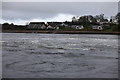
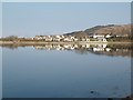
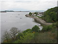
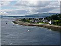
This barrow stands on an elevated site sheltered by mature trees and looks down onto Loch Etive where it meets the sea.
The site is 120 metres ESE of the Loch Nell Hotel in North Connel, a small housing scheme backs onto it and various footpaths pass it.
The barrow is covered in young bluebells, trees and brambles and several rabbits have set up home.
It measures 12.2 metres in diameter by 2 metres in height and appears to be composed of earth and gravel.
If you can imagine the site without the houses and Connel bridge this location would have been stunning the sun rising behind Ben Cruachan and setting beyond Mull and the Etive flowing below.
You may be viewing yesterday's version of this page. To see the most up to date information please register for a free account.
")
")
")
Do not use the above information on other web sites or publications without permission of the contributor.
Nearby Images from Geograph Britain and Ireland:
©2009(licence)
©2012(licence)
©2014(licence)
©2015(licence)
©2013(licence)
The above images may not be of the site on this page, they are loaded from Geograph.
Please Submit an Image of this site or go out and take one for us!
Click here to see more info for this site
Nearby sites
Key: Red: member's photo, Blue: 3rd party photo, Yellow: other image, Green: no photo - please go there and take one, Grey: site destroyed
Download sites to:
KML (Google Earth)
GPX (GPS waypoints)
CSV (Garmin/Navman)
CSV (Excel)
To unlock full downloads you need to sign up as a Contributory Member. Otherwise downloads are limited to 50 sites.
Turn off the page maps and other distractions
Nearby sites listing. In the following links * = Image available
992m SE 127° Connel Station (Oban) Standing Stone (Menhir) (NM91693408)
1.9km NNE 33° Dalvule* Cairn (NM92043626)
2.0km NE 36° Achnacree Cairn* Round Cairn (NM922363)
2.6km NE 48° Achnacreebeag* Chambered Cairn (NM92963639)
3.3km WSW 255° Dunstaffnage Round Houses* Ancient Village or Settlement (NM877340)
3.3km NNW 347° Benderloch Standing Stone* Standing Stone (Menhir) (NM903380)
3.5km SSE 167° Kilvaree standing stone* Standing Stone (Menhir) (NM91553124)
3.5km ENE 60° Achnaba C* Cairn (NM94093630)
3.6km NNW 347° Dun Mac Sniachan* Vitrified Fort (NM90323822)
3.7km ENE 62° Achnaba D* Cairn (NM94283631)
3.8km ENE 65° Achnaba A* Cairn (NM94453616)
3.8km N 353° Benderloch Stone Circle* Stone Circle (NM90613853)
3.9km ENE 64° Achnaba B* Cairn (NM94533626)
4.0km ENE 63° Achnaba E* Cairn (NM94593639)
4.9km N 2° Culcharron cairn* Cairn (NM913396)
5.1km NNW 344° Kintaline Mill Farm Kist* Cist (NM89793971)
5.2km SW 226° Pennyfuir Cairn Cairn (NM86993128)
5.5km N 359° Castle Farm standing stone* Standing Stone (Menhir) (NM911402)
5.6km S 180° Strontoiller circle* Stone Circle (NM90672914)
5.6km N 358° Castle Farm cairns* Cairn (NM91014029)
5.6km S 179° Strontoiller Large Cairn* Cairn (NM90732907)
5.7km S 179° Clach na Carraig* Standing Stone (Menhir) (NM9076728957)
5.8km S 179° Diarmid's Grave* Cairn (NM9077828950)
5.8km E 94° Dun Chathach (Connel) Hillfort (NM96743401)
6.1km SSE 166° Glenamachrie Cairn* Cairn (NM92132870)
View more nearby sites and additional images


 We would like to know more about this location. Please feel free to add a brief description and any relevant information in your own language.
 Wir möchten mehr über diese Stätte erfahren. Bitte zögern Sie nicht, eine kurze Beschreibung und relevante Informationen in Deutsch hinzuzufügen.
 Nous aimerions en savoir encore un peu sur les lieux. S'il vous plaît n'hesitez pas à ajouter une courte description et tous les renseignements pertinents dans votre propre langue.
 Quisieramos informarnos un poco más de las lugares. No dude en añadir una breve descripción y otros datos relevantes en su propio idioma.