


<< Text Pages >> Brae of Achnahaird - Stone Fort or Dun in Scotland in Highlands
Submitted by Andy B on Thursday, 02 September 2010 Page Views: 4777
Multi-periodSite Name: Brae of AchnahairdCountry: Scotland
NOTE: This site is 4.08 km away from the location you searched for.
County: Highlands Type: Stone Fort or Dun
Map Ref: NC01701380
Latitude: 58.068766N Longitude: 5.363689W
Condition:
| 5 | Perfect |
| 4 | Almost Perfect |
| 3 | Reasonable but with some damage |
| 2 | Ruined but still recognisable as an ancient site |
| 1 | Pretty much destroyed, possibly visible as crop marks |
| 0 | No data. |
| -1 | Completely destroyed |
| 5 | Superb |
| 4 | Good |
| 3 | Ordinary |
| 2 | Not Good |
| 1 | Awful |
| 0 | No data. |
| 5 | Can be driven to, probably with disabled access |
| 4 | Short walk on a footpath |
| 3 | Requiring a bit more of a walk |
| 2 | A long walk |
| 1 | In the middle of nowhere, a nightmare to find |
| 0 | No data. |
| 5 | co-ordinates taken by GPS or official recorded co-ordinates |
| 4 | co-ordinates scaled from a detailed map |
| 3 | co-ordinates scaled from a bad map |
| 2 | co-ordinates of the nearest village |
| 1 | co-ordinates of the nearest town |
| 0 | no data |
Internal Links:
External Links:
I have visited· I would like to visit
megalithicmatt couldn't find on 1st Jan 2005 - their rating: Amb: 4 Access: 3 Couldn't see it but I don't think I was trying all that hard.
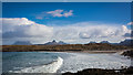
This dun and its outwork occupy a narrow promontory overlooking the S side of Achnahaird Bay. It is roughly rectangular on plan, measuring about 18m from NE to SW by 5.5m transversely within a wall which, where it crosses the neck of the promontory, measures 3m in thickness by 0.9m in height, elsewhere it is of slighter build (1.5m thick) and only survives on the NW, the remainder probably having fallen into the sea. The entrance, which is indicated by a dip in the line of the wall and what may be a door-check on the NW side of the passage, lies in the centre of the cross wall. In the interior the only feature visible is a wall that appears to have been inserted to reduce the size of the space available for occupation. The roughly D-shaped outwork abuts the main cross wall and was probably entered through a passage opposite the main entrance. Within the interior there is a short arc of bank which may have formed part of a later structure, possibly a hut, inserted into the W angle of the outwork. The only other feature is a stretch of walling springing from the W of the outwork which cuts off access from the beach below.
More at Scotland's Places
You may be viewing yesterday's version of this page. To see the most up to date information please register for a free account.
Do not use the above information on other web sites or publications without permission of the contributor.
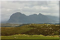
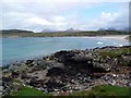
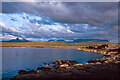
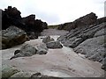
Nearby Images from Geograph Britain and Ireland:
©2008(licence)
©2009(licence)
©2022(licence)
©2009(licence)
©2017(licence)
The above images may not be of the site on this page, they are loaded from Geograph.
Please Submit an Image of this site or go out and take one for us!
Click here to see more info for this site
Nearby sites
Key: Red: member's photo, Blue: 3rd party photo, Yellow: other image, Green: no photo - please go there and take one, Grey: site destroyed
Download sites to:
KML (Google Earth)
GPX (GPS waypoints)
CSV (Garmin/Navman)
CSV (Excel)
To unlock full downloads you need to sign up as a Contributory Member. Otherwise downloads are limited to 50 sites.
Turn off the page maps and other distractions
Nearby sites listing. In the following links * = Image available
5.2km ENE 68° Inverpolly Stone Fort or Dun (NC06611551)
7.0km SSE 167° Achlochan Broch* Broch or Nuraghe (NC029069)
14.1km N 5° Clachtoll Stone Circle* Stone Circle (NC037278)
14.2km N 5° Clachtoll Broch* Broch or Nuraghe (NC03652785)
16.0km SE 141° Dun Canna* Stone Fort or Dun (NC11160080)
16.8km SSE 149° Isle Martin Cross Stone* Ancient Cross (NH096989)
17.1km N 3° Loch Na Claise Crannog (NC03543082)
18.1km NE 49° Loch Assynt Crannog (NC1603225018)
18.9km SE 126° An Dun, Strath Canaird Stone Fort or Dun (NC16530196)
20.6km E 92° Glacbain* Cairn (NC2231112011)
21.2km S 190° Stones near Mungasdale Natural Stone / Erratic / Other Natural Feature (NG9686393111)
21.7km E 89° Cam Loch B Chambered Cairn (NC23431314)
21.7km E 89° Cam Loch A Cairn (NC23501312)
22.0km SSW 212° Mellon Udrigle Hut Circle* Ancient Village or Settlement (NG891957)
22.1km E 91° Ledmore* Chambered Cairn (NC23821215)
23.1km E 86° Ledbeg River* Chambered Cairn (NC24891411)
23.1km SSE 161° Beinn Ghobhlach Standing Stone* Standing Stone (Menhir) (NH080915)
24.1km E 93° Loch Borralan Crannog* Crannog (NC25741138)
24.4km E 93° Loch Borralan West* Chambered Cairn (NC2603811142)
24.5km ENE 63° Ardvreck* Chambered Cairn (NC24142371)
24.6km E 93° Loch Borralan East* Chambered Cairn (NC26241118)
24.6km ENE 59° Allt Sgiathaig* Chambered Cairn (NC23412552)
24.6km NE 35° An Dun (Loch Ardbhair)* Broch or Nuraghe (NC16893324)
24.9km E 94° Altnacealgach* Chambered Cairn (NC2652811033)
25.2km E 80° Allt nan Uamh Bone Caves* Cave or Rock Shelter (NC268170)
View more nearby sites and additional images


 We would like to know more about this location. Please feel free to add a brief description and any relevant information in your own language.
 Wir möchten mehr über diese Stätte erfahren. Bitte zögern Sie nicht, eine kurze Beschreibung und relevante Informationen in Deutsch hinzuzufügen.
 Nous aimerions en savoir encore un peu sur les lieux. S'il vous plaît n'hesitez pas à ajouter une courte description et tous les renseignements pertinents dans votre propre langue.
 Quisieramos informarnos un poco más de las lugares. No dude en añadir una breve descripción y otros datos relevantes en su propio idioma.