 with our Megalithic Portal iPhone app")


<< Our Photo Pages >> Cross Street, Helston - Ancient Cross in England in Cornwall
Submitted by lucasn on Friday, 10 May 2019 Page Views: 1072
Early Medieval (Dark Age)Site Name: Cross Street, HelstonCountry: England
NOTE: This site is 0.672 km away from the location you searched for.
County: Cornwall Type: Ancient Cross
Nearest Town: Helston
Map Ref: SW6584827652
Latitude: 50.102697N Longitude: 5.275762W
Condition:
| 5 | Perfect |
| 4 | Almost Perfect |
| 3 | Reasonable but with some damage |
| 2 | Ruined but still recognisable as an ancient site |
| 1 | Pretty much destroyed, possibly visible as crop marks |
| 0 | No data. |
| -1 | Completely destroyed |
| 5 | Superb |
| 4 | Good |
| 3 | Ordinary |
| 2 | Not Good |
| 1 | Awful |
| 0 | No data. |
| 5 | Can be driven to, probably with disabled access |
| 4 | Short walk on a footpath |
| 3 | Requiring a bit more of a walk |
| 2 | A long walk |
| 1 | In the middle of nowhere, a nightmare to find |
| 0 | No data. |
| 5 | co-ordinates taken by GPS or official recorded co-ordinates |
| 4 | co-ordinates scaled from a detailed map |
| 3 | co-ordinates scaled from a bad map |
| 2 | co-ordinates of the nearest village |
| 1 | co-ordinates of the nearest town |
| 0 | no data |
Internal Links:
External Links:
I have visited· I would like to visit
hallsifer would like to visit
lucasn visited on 8th May 2019 - their rating: Cond: 4 Amb: 3 Access: 5
")
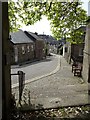
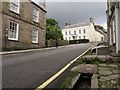
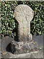
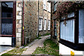
This Medieval wheel head wayside cross is located in a hedge where Cross Street meets Church Street in the town of Helston.
The cross is recorded as "The cross survives as a decorated wheel-head and shaft in a modern base, set into a pavement and backing onto a garden hedge. The cross measures up to 0.9m high. The head and shaft are decorated on one side with a Latin cross in relief with flared arms and head, and the shaft of the relief cross extends down the shaft of the cross itself. The cross head was first described by Langdon in 1896. The shaft was found subsequently, in 1900, and incorporated into the pavement. The wayside cross is thought to be close to its original location."
You may be viewing yesterday's version of this page. To see the most up to date information please register for a free account.
")
")
")
Do not use the above information on other web sites or publications without permission of the contributor.
Nearby Images from Geograph Britain and Ireland:
©2019(licence)
©2007(licence)
©2019(licence)
©2019(licence)
©2010(licence)
The above images may not be of the site on this page, they are loaded from Geograph.
Please Submit an Image of this site or go out and take one for us!
Click here to see more info for this site
Nearby sites
Key: Red: member's photo, Blue: 3rd party photo, Yellow: other image, Green: no photo - please go there and take one, Grey: site destroyed
Download sites to:
KML (Google Earth)
GPX (GPS waypoints)
CSV (Garmin/Navman)
CSV (Excel)
To unlock full downloads you need to sign up as a Contributory Member. Otherwise downloads are limited to 50 sites.
Turn off the page maps and other distractions
Nearby sites listing. In the following links * = Image available
68m NW 313° St Michael's Church Helston Crosses* Ancient Cross (SW658277)
1.3km N 351° Venton Gassick* Holy Well or Sacred Spring (SW657289)
1.4km E 79° Crasken Round Ancient Village or Settlement (SW67262786)
1.9km W 262° Garland Round Ancient Village or Settlement (SW63912745)
2.0km ENE 63° St Wendronas* Holy Well or Sacred Spring (SW677285)
3.6km N 350° Prospidnick Hill* Hillfort (SW654312)
3.9km NNE 28° Wendron Church Cornish Crosses* Ancient Cross (SW678310)
3.9km N 358° Prospidnick Menhir* Standing Stone (Menhir) (SW65913155)
4.1km W 278° Breage Church Cross* Ancient Cross (SW618284)
4.6km W 277° Trevena Cross* Ancient Cross (SW6130328435)
4.6km NNW 347° Men Amber* Natural Stone / Erratic / Other Natural Feature (SW650322)
4.6km NNE 30° Mortar outcrop at Poldark Mine* Rock Outcrop (SW6833931568)
4.7km NE 43° Beacon Hut* Chambered Cairn (SW692309)
4.8km E 87° Tolvan* Holed Stone (SW70622770)
4.8km NNW 328° Nancegollan Standing Stone Standing Stone (Menhir) (SW635318)
4.9km ENE 67° Merther Euny* Holy Well or Sacred Spring (SW70422939)
5.0km SSE 165° Burnow Round Ancient Village or Settlement (SW669228)
5.4km NE 39° Trewavas Round* Ancient Village or Settlement (SW69433166)
5.4km SE 136° Polwyn Round Ancient Village or Settlement (SW694236)
5.5km SE 145° Treloskan Round Ancient Village or Settlement (SW688230)
5.6km ESE 117° Mawgan in Meneage* Standing Stone (Menhir) (SW7071524869)
5.7km WNW 285° Tregonning hill tumulus* Round Cairn (SW604294)
5.7km SE 138° Kaledna Round Ancient Village or Settlement (SW695232)
6.0km WNW 291° Tregonning Hill Round* Ancient Village or Settlement (SW60273002)
6.1km WNW 284° Tresoweshill Well* Holy Well or Sacred Spring (SW5999129381)
View more nearby sites and additional images


 We would like to know more about this location. Please feel free to add a brief description and any relevant information in your own language.
 Wir möchten mehr über diese Stätte erfahren. Bitte zögern Sie nicht, eine kurze Beschreibung und relevante Informationen in Deutsch hinzuzufügen.
 Nous aimerions en savoir encore un peu sur les lieux. S'il vous plaît n'hesitez pas à ajouter une courte description et tous les renseignements pertinents dans votre propre langue.
 Quisieramos informarnos un poco más de las lugares. No dude en añadir una breve descripción y otros datos relevantes en su propio idioma.