


<< Our Photo Pages >> Figgy Dowdy's Well - Holy Well or Sacred Spring in England in Cornwall
Submitted by Thorgrim on Monday, 29 March 2004 Page Views: 16745
Springs and Holy WellsSite Name: Figgy Dowdy's Well Alternative Name: Maggy Figgy, Margery DawCountry: England
NOTE: This site is 0.614 km away from the location you searched for.
County: Cornwall Type: Holy Well or Sacred Spring
Nearest Town: Redruth Nearest Village: Lanner
Map Ref: SW7146740637 Landranger Map Number: 203
Latitude: 50.221485N Longitude: 5.205112W
Condition:
| 5 | Perfect |
| 4 | Almost Perfect |
| 3 | Reasonable but with some damage |
| 2 | Ruined but still recognisable as an ancient site |
| 1 | Pretty much destroyed, possibly visible as crop marks |
| 0 | No data. |
| -1 | Completely destroyed |
| 5 | Superb |
| 4 | Good |
| 3 | Ordinary |
| 2 | Not Good |
| 1 | Awful |
| 0 | No data. |
| 5 | Can be driven to, probably with disabled access |
| 4 | Short walk on a footpath |
| 3 | Requiring a bit more of a walk |
| 2 | A long walk |
| 1 | In the middle of nowhere, a nightmare to find |
| 0 | No data. |
| 5 | co-ordinates taken by GPS or official recorded co-ordinates |
| 4 | co-ordinates scaled from a detailed map |
| 3 | co-ordinates scaled from a bad map |
| 2 | co-ordinates of the nearest village |
| 1 | co-ordinates of the nearest town |
| 0 | no data |
Internal Links:
External Links:
I have visited· I would like to visit
lucasn would like to visit
LiveAndrew visited on 13th Jan 2022 - their rating: Cond: 3 Amb: 3 Access: 4 Oddly difficult to spot on the way up Carn Marth but dead easy if coming down! If on the way up, look for a very small gap on the right-hand side about 20m before you reach the amphitheatre quarry. The turning double-backs and leads to a short series of granite steps heading down to the Well. Once found, you'll not understand how you had missed it all those times before :)
LiveAndrew couldn't find on 22nd Jul 2021
LiveAndrew couldn't find on 28th Dec 2020
cazzyjane have visited here
")
According to RootsWeb.com, this well is also known as Maggy Figgy and Margery Daw and was a popular place to christen your doll on Good Friday.
The well has been restored by the Carn Marth Preservation Group and is kept locked as a safety measure. I’m sure Figgy Dowdy would approve of this as the rhyme ….
Figgy Dowdy had a well,
On the top of Carn Marth hill,
And she locked it night and day,
Lest they took her water away.
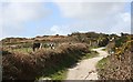
…. is associated with the well. To visit, take the A393 from Redruth to Falmouth, at the top of the hill between Redruth and Lanner, turn left into Carn Marth Lane. Park by the old engine house and walk toward the top of the hill. After passing the last house but before the old quarry, steps lead off to the right (downhill). The well is a very short distance at the bottom of the steps. The steps may be very hard to locate once the summer grass gets growing. After visiting the well it's worth continuing the short climb to the top of Carn Marth for a wonderful view of the surrounding country.
You may be viewing yesterday's version of this page. To see the most up to date information please register for a free account.
")
")
")
Do not use the above information on other web sites or publications without permission of the contributor.
Nearby Images from Geograph Britain and Ireland:

©2006(licence)
©2006(licence)
©2006(licence)
©2014(licence)
©2019(licence)
The above images may not be of the site on this page, they are loaded from Geograph.
Please Submit an Image of this site or go out and take one for us!
Click here to see more info for this site
Nearby sites
Key: Red: member's photo, Blue: 3rd party photo, Yellow: other image, Green: no photo - please go there and take one, Grey: site destroyed
Download sites to:
KML (Google Earth)
GPX (GPS waypoints)
CSV (Garmin/Navman)
CSV (Excel)
To unlock full downloads you need to sign up as a Contributory Member. Otherwise downloads are limited to 50 sites.
Turn off the page maps and other distractions
Nearby sites listing. In the following links * = Image available
2.1km NW 306° St Rumon's Cross* Ancient Cross (SW69804195)
2.4km SE 140° Trebowland Round* Ancient Village or Settlement (SW72923874)
2.5km WNW 283° St Euny's Well (Carn Brea)* Holy Well or Sacred Spring (SW691413)
2.5km WSW 241° Carnkie tumuli* Barrow Cemetery (SW692395)
2.6km E 95° St Gwennap's Well Holy Well or Sacred Spring (SW741403)
2.7km S 188° Penhalvean Cross* Ancient Cross (SW71003799)
2.8km W 269° Menhir Carn Brea (Redruth)* Standing Stone (Menhir) (SW687407)
2.9km W 272° Carn Brea Well* Holy Well or Sacred Spring (SW68584085)
2.9km SSE 150° Trewithen Round Ancient Village or Settlement (SW72833802)
3.0km W 269° Carn Brea Enclosure* Ancient Village or Settlement (SW685407)
3.0km SW 223° Gregwartha Tumuli* Barrow Cemetery (SW693385)
3.6km SE 140° Seaureaugh standing Stone* Standing Stone (Menhir) (SW73723776)
3.8km W 261° Bosleake Stones* Modern Stone Circle etc (SW67674018)
3.8km SSE 153° Stithians Vicarage Garden Cross* Ancient Cross (SW73083716)
3.9km SSE 152° St Stithians Churchyard Cross* Ancient Cross (SW73123713)
4.1km WSW 255° Canarthen Cross* Ancient Cross (SW67453973)
4.4km SSW 204° Carnmenellis Outcrop* Rock Outcrop (SW69533669)
4.5km SSW 203° Carnmenellis Tor cairn* Rock Outcrop (SW69553657)
4.6km S 183° Colvennor Standing Stone* Modern Stone Circle etc (SW71073610)
4.6km SSW 202° Carnmenellis cairn* Cairn (SW69563644)
4.7km SE 130° Lady Holy Well* Holy Well or Sacred Spring (SW7492937503)
4.7km SW 230° Vincent's Well Holy Well or Sacred Spring (SW677378)
4.8km SSE 160° Tretheague Ancient Cross* Ancient Cross (SW729361)
4.8km SSW 203° Carnmenellis Giant's Cave* Natural Stone / Erratic / Other Natural Feature (SW69403634)
4.9km W 279° Camborne School of Mines Geological Museum Museum (SW666416)
View more nearby sites and additional images


 We would like to know more about this location. Please feel free to add a brief description and any relevant information in your own language.
 Wir möchten mehr über diese Stätte erfahren. Bitte zögern Sie nicht, eine kurze Beschreibung und relevante Informationen in Deutsch hinzuzufügen.
 Nous aimerions en savoir encore un peu sur les lieux. S'il vous plaît n'hesitez pas à ajouter une courte description et tous les renseignements pertinents dans votre propre langue.
 Quisieramos informarnos un poco más de las lugares. No dude en añadir una breve descripción y otros datos relevantes en su propio idioma.