

<< Our Photo Pages >> Cronk Karran - Ancient Village or Settlement in Channel Islands and Isle of Man in Isle of Man
Submitted by Anonymous on Friday, 26 March 2004 Page Views: 7285
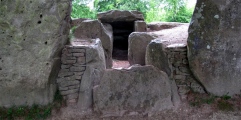
Multi-periodSite Name: Cronk KarranCountry: Channel Islands and Isle of Man
NOTE: This site is 47.195 km away from the location you searched for.
Island: Isle of Man Type: Ancient Village or Settlement
Map Ref: SC192664
Map Number: 95
Latitude: 54.061734N Longitude: 4.764051W
Condition:
| 5 | Perfect |
| 4 | Almost Perfect |
| 3 | Reasonable but with some damage |
| 2 | Ruined but still recognisable as an ancient site |
| 1 | Pretty much destroyed, possibly visible as crop marks |
| 0 | No data. |
| -1 | Completely destroyed |
| 5 | Superb |
| 4 | Good |
| 3 | Ordinary |
| 2 | Not Good |
| 1 | Awful |
| 0 | No data. |
| 5 | Can be driven to, probably with disabled access |
| 4 | Short walk on a footpath |
| 3 | Requiring a bit more of a walk |
| 2 | A long walk |
| 1 | In the middle of nowhere, a nightmare to find |
| 0 | No data. |
| 5 | co-ordinates taken by GPS or official recorded co-ordinates |
| 4 | co-ordinates scaled from a detailed map |
| 3 | co-ordinates scaled from a bad map |
| 2 | co-ordinates of the nearest village |
| 1 | co-ordinates of the nearest town |
| 0 | no data |
Internal Links:
External Links:
I have visited· I would like to visit
ShamrockStone FrothNinja have visited here
")
Have you visited this site? Please contribute a description or any thoughts by adding a comment.
You may be viewing yesterday's version of this page. To see the most up to date information please register for a free account.
")
")
")
")
")
Do not use the above information on other web sites or publications without permission of the contributor.
Click here to see more info for this site
Nearby sites
Click here to view sites on an interactive map of the areaKey: Red: member's photo, Blue: 3rd party photo, Yellow: other image, Green: no photo - please go there and take one, Grey: site destroyed
Download sites to:
KML (Google Earth)
GPX (GPS waypoints)
CSV (Garmin/Navman)
CSV (Excel)
To unlock full downloads you need to sign up as a Contributory Member. Otherwise downloads are limited to 50 sites.
![]()
Turn off the page maps and other distractions
Nearby sites listing. In the following links * = Image available
1.4km NNW 348° Meayll Hill* Chambered Cairn (SC18956778)
2.6km NE 39° Giant's Quoiting Stone* Standing Stone (Menhir) (SC20886833)
2.8km N 6° St Catherine's Well (Port Erin)* Holy Well or Sacred Spring
3.2km NE 42° Port St Mary Cists* Cist (SC21456868)
5.7km ENE 69° Keeill Vael* Ancient Village or Settlement (SC246682)
5.8km ENE 70° Chapel Hill (Isle of Man)* Hillfort (SC247682)
6.1km NNE 27° Ballakilpheric* Standing Stone (Menhir) (SC222717)
7.6km ENE 65° Billown Mooar Standing Stone Standing Stones
8.3km ENE 61° Billown Stone Circle (SC267701)
8.7km ENE 63° Ballahot Standing Stone* Modern Stone Circle etc (SC272700)
8.8km NE 48° Chibbyr Undin* Holy Well or Sacred Spring (SC2672)
9.6km ENE 60° The Monks' Well (Ballasalla)* Holy Well or Sacred Spring
10.9km ENE 73° Cass ny Hawin Hillfort Hillfort (SC298692)
11.9km ENE 68° Arragon Mooar* Round Barrow(s)
13.1km ENE 70° Cronk ny Merriu* Promontory Fort / Cliff Castle (SC317704)
14.1km ENE 64° Ballakelly* Chambered Tomb (SC32147199)
16.4km ENE 58° Speke Keeill Ancient Burial Site Early Christian Sculptured Stone (SC335746)
16.7km NE 50° The Braaid* Ancient Village or Settlement (SC32517655)
16.7km NE 50° Braaid Circle* Ancient Village or Settlement (SC325766)
16.8km NE 45° St Ronan's Well Holy Well or Sacred Spring (SC3162077766)
16.9km NE 45° St. Patrick's Chair* Early Christian Sculptured Stone (SC3165577946)
17.1km NNE 12° Corrin's Tower* Modern Stone Circle etc
17.7km NNE 27° Ballaharra stones Burial Chamber or Dolmen
17.7km NNE 27° Giant's grave (St John's)* Cist (SC27758193)
17.7km NNE 34° Chibbyr Roney* Holy Well or Sacred Spring (SC296808)
View more nearby sites and additional images


 We would like to know more about this location. Please feel free to add a brief description and any relevant information in your own language.
 Wir möchten mehr über diese Stätte erfahren. Bitte zögern Sie nicht, eine kurze Beschreibung und relevante Informationen in Deutsch hinzuzufügen.
 Nous aimerions en savoir encore un peu sur les lieux. S'il vous plaît n'hesitez pas à ajouter une courte description et tous les renseignements pertinents dans votre propre langue.
 Quisieramos informarnos un poco más de las lugares. No dude en añadir una breve descripción y otros datos relevantes en su propio idioma.