


<< Our Photo Pages >> Water Mine / Fortress Ronda - Ancient Mine, Quarry or other Industry in Spain in Andalucía
Submitted by Maatje on Thursday, 09 February 2023 Page Views: 440
Medieval (High and Late)Site Name: Water Mine / Fortress Ronda Alternative Name: Casa del Rey WatermillCountry: Spain Region: Andalucía Type: Ancient Mine, Quarry or other Industry
Nearest Town: Málaga Nearest Village: Ronda
Latitude: 36.739900N Longitude: 5.164209W
Condition:
| 5 | Perfect |
| 4 | Almost Perfect |
| 3 | Reasonable but with some damage |
| 2 | Ruined but still recognisable as an ancient site |
| 1 | Pretty much destroyed, possibly visible as crop marks |
| 0 | No data. |
| -1 | Completely destroyed |
| 5 | Superb |
| 4 | Good |
| 3 | Ordinary |
| 2 | Not Good |
| 1 | Awful |
| 0 | No data. |
| 5 | Can be driven to, probably with disabled access |
| 4 | Short walk on a footpath |
| 3 | Requiring a bit more of a walk |
| 2 | A long walk |
| 1 | In the middle of nowhere, a nightmare to find |
| 0 | No data. |
| 5 | co-ordinates taken by GPS or official recorded co-ordinates |
| 4 | co-ordinates scaled from a detailed map |
| 3 | co-ordinates scaled from a bad map |
| 2 | co-ordinates of the nearest village |
| 1 | co-ordinates of the nearest town |
| 0 | no data |
Internal Links:
External Links:
")
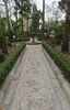
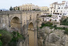
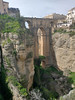
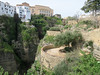
The Water Mine / Fortress in Ronda was build in the beginning of the 14th century so it dates back to the Moorish period, under King Abomelic. It is partly carved in the rock and partly built against the rocks of the El Tajo Gorge. Visiters can walk the stairs untill the river, 231 steps and 60 meters lower. There are several viewpoints and rooms to be seen. A waterwheel with buckets could bring the water in the room of the spring and slaves had to form a chain to bring the water to the city in case of wartime eg.
You may be viewing yesterday's version of this page. To see the most up to date information please register for a free account.
")
")
")
Do not use the above information on other web sites or publications without permission of the contributor.
Nearby Images from Flickr

The above images may not be of the site on this page, but were taken nearby. They are loaded from Flickr so please click on them for image credits.
Click here to see more info for this site
Nearby sites
Click here to view sites on an interactive map of the areaKey: Red: member's photo, Blue: 3rd party photo, Yellow: other image, Green: no photo - please go there and take one, Grey: site destroyed
Download sites to:
KML (Google Earth)
GPX (GPS waypoints)
CSV (Garmin/Navman)
CSV (Excel)
To unlock full downloads you need to sign up as a Contributory Member. Otherwise downloads are limited to 50 sites.
Turn off the page maps and other distractions
Nearby sites listing. In the following links * = Image available
7.7km SSW 211° Encinas Boracchas* Burial Chamber or Dolmen
7.7km SSW 211° Dolmen del puerto de Encinas Borrachas* Burial Chamber or Dolmen
8.7km SSW 212° Dólmen de Monteiro* Burial Chamber or Dolmen
9.7km SSW 209° Dólmen del Cortijo de la Mimbre Burial Chamber or Dolmen
10.7km WNW 297° Ronda Dolmen* Burial Chamber or Dolmen
10.9km WSW 240° La Pileta* Cave or Rock Shelter
12.2km NNW 327° Acinipo* Ancient Village or Settlement
18.1km W 277° Caldaza Medieval Trackway* Ancient Trackway
18.3km NW 309° Dolmen El Charcón* Burial Chamber or Dolmen
18.3km ENE 72° Dólmen del Cerro de la Cruz Blanca Burial Chamber or Dolmen
18.4km NW 310° El Charcón II* Burial Chamber or Dolmen
23.1km N 7° Dólmen de los Tomillos 3* Chambered Tomb
23.1km N 7° Dólmen de los Tomillos 1* Burial Chamber or Dolmen
23.1km N 7° Dólmen de los Tomillos 2* Burial Chamber or Dolmen
25.8km WSW 256° Calzada Ubrique-Benaocaz* Ancient Trackway
25.9km WSW 257° Ciudad Palatina Ocuri Ancient Village or Settlement
28.4km E 99° Dolmen El Tesorillo de La Llaná* Burial Chamber or Dolmen
29.3km E 97° Dólmen de la Cuesta de los Almendrillos* Burial Chamber or Dolmen
29.9km NE 37° Dólmenes del Guadalteba Burial Chamber or Dolmen
32.8km S 187° Necrópolis Prehistórica de Corominas* Museum
33.3km SSE 165° Villa Romana de las Torres* Ancient Village or Settlement
33.3km ENE 64° Cueva de Dona Trinidad* Cave or Rock Shelter
35.4km SSW 201° Ruinas Romanas de Lacipo* Ancient Village or Settlement
38.3km NE 53° Necrópolis de las Aguilillas* Rock Cut Tomb
38.6km ENE 62° Ruines de Bobastro* Ancient Village or Settlement
View more nearby sites and additional images


 We would like to know more about this location. Please feel free to add a brief description and any relevant information in your own language.
 Wir möchten mehr über diese Stätte erfahren. Bitte zögern Sie nicht, eine kurze Beschreibung und relevante Informationen in Deutsch hinzuzufügen.
 Nous aimerions en savoir encore un peu sur les lieux. S'il vous plaît n'hesitez pas à ajouter une courte description et tous les renseignements pertinents dans votre propre langue.
 Quisieramos informarnos un poco más de las lugares. No dude en añadir una breve descripción y otros datos relevantes en su propio idioma.